Louville
Contents
Louville
| Lat: 44.0°N, Long: 46.0°W, Diam: 36 km, Depth: 1.87 km, Rükl: 9 |
Table of Contents
[#Louville Louville]
[#Louville-Images Images]
[#Louville-Maps Maps]
[#Louville-Description Description]
[#Louville-Description: Elger Description: Elger]
[#Louville-Description: Wikipedia Description: Wikipedia]
[#Louville-Additional Information Additional Information]
[#Louville-Nomenclature Nomenclature]
[#Louville-LPOD Articles LPOD Articles]
[#Louville-Bibliography Bibliography]

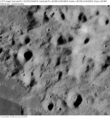
LO-IV-158H Louville, according to the position and diameter listed in the on-line IAU Planetary Gazetteer occupies the central part of this frame, but it is very difficult to see any clear evidence of a distinct crater at this location. To the left of center, the crater with the largest shadow is 8-km Louville B. Theoretically, this lies just inside the west rim of "Louville". On the bottom, the same-sized Louville A has an inner feature that makes it look a bit like an incompletely-developed concentric crater. Louville A is just outside the southeast rim of "Louville". To its left, 6-km Louville E is also just outside the official south rim of "Louville". Low sun views reveal mostly that Louville B and the sunlit ridge in the right-hand part of this view are a bit taller than the many other hills in this mountainous area.
Images
LPOD Photo Gallery Lunar Orbiter Images Apollo Images
Louville DA, which is Concentric Crater number 37 in C.A.Wood's list of 1978, is visible near the lower margin of Lunar Orbiter 4's frame LOIV-163-h3. In the same photograph, near the frame's lower left corner, is a peculiar surface formation which shows something like a "double western rim". Is this some sort of possible Concentric Crater tendency?
Research: Danny Caes
Maps
(LAC zone 23B4) LAC map Geologic map
Description
Description: Elger
(IAU Directions) LOUVILLE.--A triangular-shaped formation on the W. of a line joining Mairan and Sharp. It is hemmed in by mountains, one of which towers 5,000 feet above its dusky floor.
Description: Wikipedia
Additional Information
- Depth data from Kurt Fisher database
- Westfall, 2000: 1.87 km
- Viscardy, 1985: 1 km
- Satellite crater Louville D is on the ALPO list of bright ray craters.
- Louville DA: Concentric Crater number 37 in C.A.Wood's list published in 1978.- DannyCaes DannyCaes Nov 2, 2009
- Northwest of Louville D (the lower left corner of L.O.4 frame 163-h3) is the location of a curious "partial double rim" (at the western part of something which seems to have been a crater). - DannyCaes DannyCaes Apr 13, 2014
Nomenclature
- Named for Jacques D'Allonville, Chevalier de Louville (1671-1732); a French astronomer and mathematician.
- According to Whitaker (p. 218), this name was introduced by Johann Schröter. However, the feature so-named by Schröter was an equally ambigous depressed area to the east of the bright ridge in the Lunar Orbiter view reproduced above. Compare Schröter's drawing (south up) to Plate B18 (north up) in the Consolidated Lunar Atlas (rotate one or the other 180° to make the correlation more clear). Schröter's "crater" is completely outside the boundary of the current IAU-named feature. - JimMosher JimMosher
- Not to be confused with Liouville.
- Louville Omega (the somewhat dogbone-shaped hill north of the bowl-shaped craters Mairan G and Rumker H (both east of Mons Rumker). See Chart 6 in the Times Atlas of the Moon.
LPOD Articles
Bibliography
This page has been edited 1 times. The last modification was made by - tychocrater tychocrater on Jun 13, 2009 3:24 pm - afx3u2