Catena Taruntius
Contents
Catena Taruntius
|
Lat: 3.0°N, Long: 48.0°E, Length: 100 km, Depth: km, Rükl: 37 |
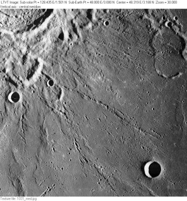
LO-I-031M Catena Taruntius can be seen extending diagonally southeast from near the northwest edge of Taruntius T to a point north of the 10-km circular crater Anville (in the lower right). The name Taruntius T refers, incidentally, to the 10-km circle bounded by the parallel low hills (the smaller of two similar-looking semi-circular enclosures in the upper right), and not to the deeply-shadowed 4.4 km circular crater just above it (labeled on AIC-61C as Taruntius TB). Taruntius itself is marked by the sunlit crater rim and floor in the extreme upper left corner. The rather large enclosure marked by the semi-circular hills just below it (near the left margin) was known as Taruntius TA in the System of Lunar Craters, a name that is no longer in use by the IAU. Below that, the 7-km circular crater bisected by the margin is Taruntius B.
Images
LPOD Photo Gallery Lunar Orbiter Images Apollo Images
Maps
(LAC zone 61C3) LAC map Geologic map AIC map LTO map
Description
Description: Wikipedia
Additional Information
- List of Lunar Catenae.
- On the Earth-based AIC-61C (1967) this unnamed feature is shown morphing into a pair of rilles north of Taruntius G (now known as Anville).
Nomenclature
- Named after the nearby crater. (Taruntius)
- The name Catena Taruntius was approved "as assigned" in 1985 (IAU Transactions XIXB). No map reference was given, but the name appears on LTO-61C3.
LPOD Articles
Bibliography
