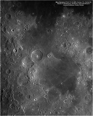
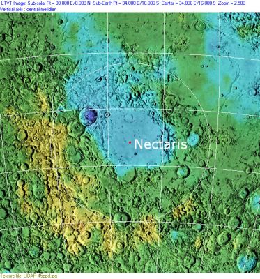
Mare Nectaris
Contents
Nectaris Basin
(unofficial name; IAU feature name for central 333 km of mare: Mare Nectaris)
|
Lat: 15.2°S, Long: 35.5°E, Diam: 333 km, Depth: km, Rükl: 58 |


Left: Howard Eskildsen.
Right: Clementine, Clementine LIDAR Altimeter texture from PDS Map-a-Planet remapped to north-up aerial view by LTVT. The dot is the center position and the white circle the main ring position from Chuck Wood's Impact Basin Database. Grid spacing = 10 degrees.
Table of Contents
[#Nectaris Basin Nectaris Basin]
[#Nectaris Basin-Images Images]
[#Nectaris Basin-Maps Maps]
[#Nectaris Basin-Basin Classification Basin Classification]
[#Nectaris Basin-Description Description]
[#Nectaris Basin-Description: Elger Description: Elger]
[#Nectaris Basin-Description: Wikipedia: Description: Wikipedia:]
[#Nectaris Basin-Additional Information Additional Information]
[#Nectaris Basin-Nomenclature Nomenclature]
[#Nectaris Basin-LPOD Articles LPOD Articles]
[#Nectaris Basin-Bibliography Bibliography]
Images
LPOD Photo Gallery Lunar Orbiter Images Apollo Images
AS08-13-2243; which is an orbital Hasselblad photograph made during the first manned mission of Project Apollo (Apollo 8 in december 1968), shows the sunrise terminator over the western part of Mare Nectaris, with the ruined crater Daguerre in the foreground (looking southward).
Apollo 11's orbital photographs AS11-42-6235, AS11-42-6236, AS11-42-6237, and AS11-42-6241 show the same area of Mare Nectaris as depicted in Apollo 8's low-sun orbital view in AS08-13-2243.
Research orbital Hasselblads: Danny Caes.
Maps
(LAC zone 79D3) LAC map Geologic map
Basin Classification
(description of terms and most numeric basin data from Wood, C.A. (2004) Impact Basin Database)
| Certainty of Existence |
USGS Age |
Wilhelms Age Group |
Ring Diameters |
Mare Thickness |
Mascon |
| Certain |
Nectarian |
10 |
240, 400, 620, 860, 1320 km |
0.8-1.2 km |
Yes; +70 mG gravity anomaly |
Description
Description: Elger
(IAU Directions) The Mare Nectaris, again, in the south-eastern quadrant, presents some fine examples of concentric ridges, which are seen to the best advantage when the morning sun is rising on Rosse, a prominent crater north of Fracastorius. This "sea" is evidently concave in cross-section, the central portion being considerably lower than the margin, and these ridges appear to mark the successive stages of the change of level from the coast-line to the centre. They suggest the "caving in" of the surface, similar to that observed on a frozen pond or river, where the "cat's ice" at the edge, through the sinking of the water beneath, is rent and tilted to a greater or less degree.
Description: Wikipedia:
Additional Information
- Mare area of 84,100 km^2 according to measurements by Jim Whitford-Stark.
Nomenclature
The IAU feature name means "Sea of Nectar".
- The impact basin is named after the mare.
LPOD Articles
- Moving West.
- Ring Around a Basin.
- A Large but Subtle Dome
- Chameleon Surface
- Huge Fractures
- Inside Nectaris
- Four Rings and a Mystery
Bibliography
- Chauhan, P. et al (2011). Studies of Lunar Dark-halo Craters in Northwestern Mare Nectaris Using High Resolution Chandrayaan-1 Data – 42nd LPSC Conference (Mar), 2011.
- Spudis, P. D.; Hawke, B. R.; Lucey, P. G. 1989. Geology and deposits of the lunar Nectaris basin. in Lunar and Planetary Science Conference, 19th, Houston, TX, Mar. 14-18, 1988, pp. 51-59.
- Wood, C.A. 20__. Rings and Things. Sky and Telescope online article
- Whitford-Stark, J.L. (1981) The evolution of the lunar Nectaris multiring basin, Icarus 48, 393-427.
This page has been edited 1 times. The last modification was made by - tychocrater tychocrater on Jun 13, 2009 3:24 pm - afx3u2//