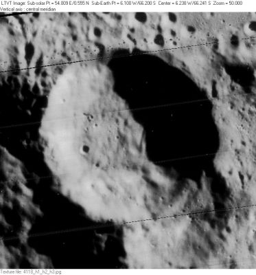
Cysatus
Contents
Cysatus
|
Lat: 66.2°S, Long: 6.1°W, Diam: 48 km, Depth: 4.25 km, Rükl: 73 |
Table of Contents
[#Cysatus Cysatus]
[#Cysatus-Images Images]
[#Cysatus-Maps Maps]
[#Cysatus-Description Description]
[#Cysatus-Description: Elger Description: Elger]
[#Cysatus-Description: Wikipedia Description: Wikipedia]
[#Cysatus-Additional Information Additional Information]
[#Cysatus-Nomenclature Nomenclature]
[#Cysatus-LPOD Articles LPOD Articles]
[#Cysatus-Bibliography Bibliography]

LO-IV-118H
Images
LPOD Photo Gallery Lunar Orbiter Images
Maps
(LAC zone 137B1) USGS Digital Atlas PDF
Description
Description: Elger
(IAU Directions) CYSATUS.--A regular walled-plain, apparently about 28 miles in diameter, forming the most northerly member of a chain of formations, of which Newton, Short, and Moretus, extending towards the S. limb, form a part. Its border rises nearly 13,000 feet above a floor devoid of prominent detail.
Description: Wikipedia
Additional Information
Depth data from Kurt Fisher database
- Westfall, 2000: 4.25 km
- Viscardy, 1985: 4 km
- From the shadows in LO-IV-118H, the east rim of Cysatus is 3140-4050 m above the floor, generally higher to the south. - JimMosher JimMosher
Nomenclature
Cysat, Jean-Baptiste; Swiss mathematician, astronomer (1588-1657).
- According to Whitaker (p. 212), this feature was labeled Cysatus Soc. I by Riccioli, with the "Soc. I" having been dropped to produce the modern spelling.
LPOD Articles
Bibliography
This page has been edited 1 times. The last modification was made by - tychocrater tychocrater on Jun 13, 2009 3:24 pm - afx3u2