Difference between revisions of "Picard"
| Line 9: | Line 9: | ||
{| class="wiki_table" | {| class="wiki_table" | ||
| | | | ||
| − | [http://www.lpod.org/coppermine/displayimage.php?pid=4921&fullsize=1 [[Image: | + | [http://www.lpod.org/coppermine/displayimage.php?pid=4921&fullsize=1 [[Image:Normal_picard.jpg|external image normal_picard.jpg]]]<br /> |
| | | | ||
[http://www.lpod.org/coppermine/albums/userpics/Picard-AS17-P2250.jpg [[Image:Picard-AS17-P2250.jpg|external image Picard-AS17-P2250.jpg]]]<br /> | [http://www.lpod.org/coppermine/albums/userpics/Picard-AS17-P2250.jpg [[Image:Picard-AS17-P2250.jpg|external image Picard-AS17-P2250.jpg]]]<br /> | ||
| Line 23: | Line 23: | ||
<br /> | <br /> | ||
==Description: Elger== | ==Description: Elger== | ||
| − | ''([http://the-moon.us/wiki/IAU% | + | ''([http://the-moon.us/wiki/IAU%20directions IAU Directions])'' PICARD.--The largest of the craters on the surface of the [http://the-moon.us/wiki/Mare%20Crisium Mare Crisium], 21 miles in diameter. The floor, which includes a central mountain, is depressed about 2,000 feet below the outer surface, and is surrounded by walls rising some 3,000 feet above the Mare. A small but lofty ring-plain, Picard E, on the W., near the border of the Mare, is remarkable for its change of aspect under different angles of illumination. A long curved ridge running S. from this, with a lower ridge on the east, sometimes resemble a large enclosure with a central mountain. Still farther S., there is another bright deep crater, <u>a</u>, with a large low ring adjoining it on the S., abutting on the S.W. border of the Mare. Schroter bestowed much attention on these and other formations on the [http://the-moon.us/wiki/Mare%20Crisium Mare Crisium], and attributed certain changes which he observed to a lunar atmosphere.<br /> <br /> |
==Description: Wikipedia== | ==Description: Wikipedia== | ||
[http://en.wikipedia.org/wiki/Picard_(crater) Picard]<br /> <br /> | [http://en.wikipedia.org/wiki/Picard_(crater) Picard]<br /> <br /> | ||
==Additional Information== | ==Additional Information== | ||
| − | Depth data from [http://the-moon.us/wiki/Kurt%20Fisher% | + | Depth data from [http://the-moon.us/wiki/Kurt%20Fisher%20Crater%20Depths Kurt Fisher database]<br /> |
* Pike, 1976: 2.32 km | * Pike, 1976: 2.32 km | ||
| Line 48: | Line 48: | ||
<br /> | <br /> | ||
==Lettered craters== | ==Lettered craters== | ||
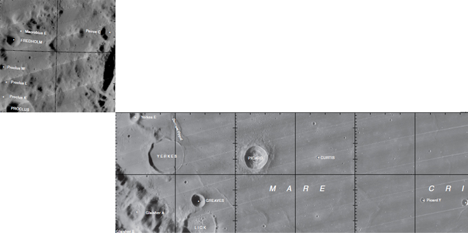
| − | [[Image: | + | [[Image:Picard-letter.jpg|picard-letter.jpg]]<br /> [http://planetarynames.wr.usgs.gov/images/Lunar/lac_43_lo.pdf LAC 43] and [http://planetarynames.wr.usgs.gov/images/Lunar/lac_65_lo.pdf LAC 62] Excerpt from the //[http://planetarynames.wr.usgs.gov/dAtlas.html USGS Digital Atlas of the Moon].<br /> <br /> |
==Bibliography== | ==Bibliography== | ||
<br /> <br /> | <br /> <br /> | ||
Latest revision as of 02:09, 16 April 2018
Contents
Picard - in Mare Crisium
|
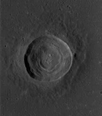
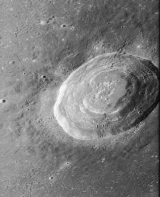
Lat: 14.54°N, Long: 54.69°E, Diam: 22.35 km, Depth: 2.32 km, Rükl 26, Eratosthenian |
Left: LROC image WAC No. M119489822ME. Calibrated by LROC_WAC_Previewer.
Right: AS 17 P2250
Images
LPOD Photo Gallery Lunar Orbiter Images Apollo Images
Maps
(LAC zone 62A1) LAC map Geologic map LM map LTO map
- IAU page: Picard
Description
Description: Elger
(IAU Directions) PICARD.--The largest of the craters on the surface of the Mare Crisium, 21 miles in diameter. The floor, which includes a central mountain, is depressed about 2,000 feet below the outer surface, and is surrounded by walls rising some 3,000 feet above the Mare. A small but lofty ring-plain, Picard E, on the W., near the border of the Mare, is remarkable for its change of aspect under different angles of illumination. A long curved ridge running S. from this, with a lower ridge on the east, sometimes resemble a large enclosure with a central mountain. Still farther S., there is another bright deep crater, a, with a large low ring adjoining it on the S., abutting on the S.W. border of the Mare. Schroter bestowed much attention on these and other formations on the Mare Crisium, and attributed certain changes which he observed to a lunar atmosphere.
Description: Wikipedia
Additional Information
Depth data from Kurt Fisher database
- Pike, 1976: 2.32 km
- Westfall, 2000: 2.32 km
- Viscardy, 1985: 2.22 km
- Cherrington, 1969: 2.31 km
- Satellite crater Picard Z is on the ALPO list of bright ray craters.
- A thermal anomaly crater, implying a youthful age - Moore et al, 1980
Lunar Ellipse of Fire
Picard and Peirce (north of Picard) are (or were?) both number ten in the list of 12 localities in the Lunar Ellipse of Fire (see article from Farouk El-Baz in Sky and Telescope - June 1973).
Nomenclature
- Jean-Felix Picard (July 21, 1620 – July 12, 1682) was a French astronomer. He was the first person to measure the size of the Earth to a reasonable degree of accuracy in a survey conducted 1669-70. Guided by Maurolycus' methodology and Snell's equipment design for doing so, Picard achieved this by measuring one degree of latitude along the Paris Meridian. His measurements produced a terrestrial radius of 6,328.9 km. The polar radius has now been measured at just over 6,357 km. This was an error only 0.44% less than the modern value. This was another example of advances in astronomy and its tools making possible advances in cartography.
- Not to be confused with Auguste Antoine Piccard.
- In the days of Hevelius (Johann Hewelcke), the crater Picard was called Insula Alopecia (Isle of Baldness?). See page 201 of Ewen A. Whitaker's Mapping and Naming the Moon (1999).- DannyCaes May 27, 2013
LPOD Articles
Lettered craters

LAC 43 and LAC 62 Excerpt from the //USGS Digital Atlas of the Moon.
Bibliography
Named Featues -- Prev: Piazzi -- Next: Piccolomini

