Difference between revisions of "Cajal"
| Line 6: | Line 6: | ||
|} | |} | ||
''(formerly '''[http://the-moon.us/wiki/Jansen Jansen] F''')''<br /> <div id="toc"> | ''(formerly '''[http://the-moon.us/wiki/Jansen Jansen] F''')''<br /> <div id="toc"> | ||
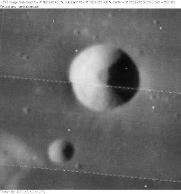
| − | [http://www.lpod.org/coppermine/albums/userpics/Cajal_LO-IV-078H_LTVT.JPG [[Image: | + | [http://www.lpod.org/coppermine/albums/userpics/Cajal_LO-IV-078H_LTVT.JPG [[Image:Normal_Cajal_LO-IV-078H_LTVT.JPG|external image normal_Cajal_LO-IV-078H_LTVT.JPG]]]<br /> ''[http://lpod.org/coppermine/displayimage.php?pos=-2604 LO-IV-078H]'' The smaller crater is not named.<br /> <br /> |
==Images== | ==Images== | ||
[http://www.lpod.org/coppermine/thumbnails.php?album=search&type=full&search=Cajal LPOD Photo Gallery] [http://www.lpi.usra.edu/resources/lunar_orbiter/bin/srch_nam.shtml?Cajal%7C0 Lunar Orbiter Images] [http://www.lpi.usra.edu/resources/apollo/search/feature/?feature=Jansen%20F Apollo Images]<br /> | [http://www.lpod.org/coppermine/thumbnails.php?album=search&type=full&search=Cajal LPOD Photo Gallery] [http://www.lpi.usra.edu/resources/lunar_orbiter/bin/srch_nam.shtml?Cajal%7C0 Lunar Orbiter Images] [http://www.lpi.usra.edu/resources/apollo/search/feature/?feature=Jansen%20F Apollo Images]<br /> | ||
| Line 24: | Line 24: | ||
* IAU page: [http://planetarynames.wr.usgs.gov/Feature/964 Cajal] | * IAU page: [http://planetarynames.wr.usgs.gov/Feature/964 Cajal] | ||
| − | * Depth data from [http://the-moon.us/wiki/Kurt%20Fisher% | + | * Depth data from [http://the-moon.us/wiki/Kurt%20Fisher%20Crater%20Depths Kurt Fisher database] |
** Westfall, 2000: 1.81 km | ** Westfall, 2000: 1.81 km | ||
** Viscardy, 1985: 1.8 km | ** Viscardy, 1985: 1.8 km | ||
Latest revision as of 01:43, 16 April 2018
Contents
Cajal
|
Lat: 12.59°N, Long: 31.08°E, Diam: 9.1 km, Depth: 1.81 km, Rükl: 36 |
LO-IV-078H The smaller crater is not named.
Images
LPOD Photo Gallery Lunar Orbiter Images Apollo Images
- Sunrise at Cajal and environs (AS8-13-2336), photographed during the mission of Apollo 8. Looking north toward Dorsa Barlow and Vitruvius (the large crater at the upper left part of the frame). The illuminated mountain in the foreground (leftward of Cajal) is the so-called Mitika Peak (thus named on Rand McNally's moonmap).
- AS8-13-2347shows the same region as mentioned above. In this photograph, the sun was several degrees above the eastern horizon, and every surface detail shows up like a lunar bass-relief map. A magnificent photograph!
- Apollo 17's orbital panoramic ITEK-camera frames AS17-P-3011, 3013, 3016, and 3018 show shadowless views of Cajal's inner slopes and floor.
- Research: Danny Caes
- HiRes scan of Apollo 8 photograph: David Woods and Frank O'Brien (Apollo 8 Flight Journal).
Maps
(LAC zone 61A1) LAC map Geologic map LTO map
Description
Wikipedia
Additional Information
- IAU page: Cajal
- Depth data from Kurt Fisher database
- Westfall, 2000: 1.81 km
- Viscardy, 1985: 1.8 km
Nomenclature
- Named for Santiago Ramón y Cajal (May 1, 1852 – October 17, 1934), a Spanish histologist, physician, and Nobel laureate. He is considered to be one of the founders of modern neuroscience.
- This replacement name for a formerly lettered crater was introduced on LTO-61A1 (for which it served as the chart title). - Jim Mosher
- Cajal appears in the cumulative list of lunar names published in IAU Transactions XVB (1973). Exactly when and how it was added is unclear, nor is the honoree designated, but biographical information was unofficially reported in Ashbrook, 1974.
- Jansen alpha; the mountainous hill southwest of Cajal, is known as the Mitika peak. This unofficial name was printed on the greenish Rand McNally moonmap and on the same moonmap in Patrick Moore's Atlas of the Universe (1983). Detection of name "Mitika peak": Danny Caes. The exact origin of this unofficial name is unknown (who was Mitika?).
LPOD Articles
Bibliography
Named Featues -- Prev: Cailleux -- Next: Cajori
