Difference between revisions of "Hansteen"
(Created page with "<div id="content_view" class="wiki" style="display: block"> =Hansteen= {| class="wiki_table" | Lat: 11.53°S, Long: 52.01°W, Diam: 44.99 km, Depth: 1.39 km, [/R%C3%BCkl%2...") |
|||
| (4 intermediate revisions by the same user not shown) | |||
| Line 3: | Line 3: | ||
{| class="wiki_table" | {| class="wiki_table" | ||
| | | | ||
| − | Lat: 11.53°S, Long: 52.01°W, Diam: 44.99 km, Depth: 1.39 km, [ | + | Lat: 11.53°S, Long: 52.01°W, Diam: 44.99 km, Depth: 1.39 km, [[R%C3%BCkl%2040|Rükl: 40]]<br /> |
|} | |} | ||
<div id="toc"> | <div id="toc"> | ||
| − | + | [http://www.lpod.org/coppermine/displayimage.php?pid=351&fullsize=1 [[Image:Normal_Arrowhead%20Billy%20Hansteen%20iv_149_h2%20.jpg|external image normal_Arrowhead%20Billy%20Hansteen%20iv_149_h2%20.jpg]]]<br /> ''[http://lpod.org/coppermine/displayimage.php?pos=-351 Lunar Orbiter IV image IV-149-H2]'', Hansteen Alpha aka [[Mons%20Hansteen|Mons Hansteen]] or the Arrowhead, [[Billy|Billy]] & Hansteen (upper left).<br /> <br /> | |
| − | |||
==Images== | ==Images== | ||
[http://www.lpod.org/coppermine/thumbnails.php?album=search&type=full&search=Hansteen LPOD Photo Gallery] [http://www.lpi.usra.edu/resources/lunar_orbiter/bin/srch_nam.shtml?Hansteen%7C0 Lunar Orbiter Images] [http://www.lpi.usra.edu/resources/apollo/search/feature/?feature=Hansteen Apollo Images]<br /> <br /> | [http://www.lpod.org/coppermine/thumbnails.php?album=search&type=full&search=Hansteen LPOD Photo Gallery] [http://www.lpi.usra.edu/resources/lunar_orbiter/bin/srch_nam.shtml?Hansteen%7C0 Lunar Orbiter Images] [http://www.lpi.usra.edu/resources/apollo/search/feature/?feature=Hansteen Apollo Images]<br /> <br /> | ||
==Maps== | ==Maps== | ||
| − | ''([ | + | ''([[LAC%20zone|LAC zone]] 74C2)'' [http://www.lpi.usra.edu/resources/mapcatalog/LAC/lac74/ LAC map] [http://www.lpi.usra.edu/resources/mapcatalog/usgs/I740/ Geologic map]<br /> <br /> |
==Description== | ==Description== | ||
<br /> | <br /> | ||
===Elger=== | ===Elger=== | ||
| − | ''([ | + | ''([[IAU%20directions|IAU Directions]])'' HANSTEEN.--A somewhat larger ring-plain, with a lower and more irregular rampart, rising on the E. to nearly 3,000 feet above the floor, which is depressed to about the same extent as that of [[Billy|Billy]]. Both the inner and outer slopes are terraced on the W., where the <u>glacis</u> is traversed by a short, delicate, rill-like valley. There are some bright curved ridges on the floor. On the E. of [[Billy|Billy]] and Hansteen is a wide inlet of the [[Oceanus%20Procellarum|Oceanus Procellarum]], bounded by the [[Letronne|Letronne]] region on the E., and on the S. by lofty highlands. On the surface, not far from the S.E. border of Hansteen, is a curious triangular-shaped mountain mass, with a digitated outline on the S., and including a small bright crater on its area. Between this and the ring- plain is a large but somewhat obscure depression, N. of which lies a rill-like object extending from the N. point of the triangular mountain to the E. wall. At the bottom of a gently sloping valley between [[Billy|Billy]] and Hansteen is a de<br /> licate marking, which seems to represent a cleft connecting the two formations.<br /> <br /> |
===Wikipedia=== | ===Wikipedia=== | ||
[http://en.wikipedia.org/wiki/Hansteen_(crater) Hansteen]<br /> <br /> | [http://en.wikipedia.org/wiki/Hansteen_(crater) Hansteen]<br /> <br /> | ||
==Additional Information== | ==Additional Information== | ||
* IAU page: [http://planetarynames.wr.usgs.gov/Feature/2354 Hansteen] | * IAU page: [http://planetarynames.wr.usgs.gov/Feature/2354 Hansteen] | ||
| − | * Depth data from [ | + | * Depth data from [[Kurt%20Fisher%20Crater%20Depths|Kurt Fisher database]] |
** Westfall, 2000: 1.39 km | ** Westfall, 2000: 1.39 km | ||
** Viscardy, 1985: 1.25 km | ** Viscardy, 1985: 1.25 km | ||
| Line 32: | Line 31: | ||
{| class="wiki_table" | {| class="wiki_table" | ||
| | | | ||
| − | [http://the-moon. | + | [http://the-moon.us/wiki/file/detail/burrell-mellonic.jpg [[Image:Burrell-mellonic.jpg|burrell-mellonic.jpg]]]<br /> |
| | | | ||
| − | '''Left:''' The feature as it appears in Schmidt's map [ | + | '''Left:''' The feature as it appears in Schmidt's map [[Schmidt%20-%2019|Sheet No. 19]].<br /> <br /> '''Middle left:''' As it appears in Wilkins's Map - Chart XIX.<br /> <br /> '''Middle right:''' Annotated, Lunar Orbiter 4 [http://www.lpi.usra.edu/resources/lunarorbiter/images/preview/4156_h3.jpg LO4-H3-4156] aerial view (square shows the region in question as it is seen today - considered by Schmidt as '''Melloni''' crater and by Wilkins as '''Burrell''' crater).<br /> <br /> '''Right:''' Annotated, Digital Elevation Model (DEM) view under low illumination using [http://ltvt.wikispaces.com/LTVT LTVT] software as a projection method to show approximately the region where '''Burrell-Melloni''' was presumed seen.<br /> <br /> ''Click image for larger view''<br /> |
|} | |} | ||
| − | * <u>'''Note:'''</u> For all images, North is to bottom, East to left (taking into account the pre-1961 cardinal-point changes - see ''[ | + | * <u>'''Note:'''</u> For all images, North is to bottom, East to left (taking into account the pre-1961 cardinal-point changes - see ''[[IAU%20directions|IAU Directions]]''). |
| − | * Clearly [ | + | * Clearly [[Julius%20Schmidt|Schmidt]] and [[Hugh%20Percy%20Wilkins|Wilkins]] show the feature as a well-marked crater, however, when looked for in the [[Beer%20and%20M%C3%A4dler|Mädler]] maps of 1837 and the Neison maps of 1876 [[Neison%20-%20Map%2012|Map 12]], the feature doesn't appear (Mädler shows it as two small ridge-like or hill-like features, while nothing at all appears on Neison's). Other, more recent mappers have also commented about the feature's appearance/disappearance, which further confused matters, for example, see this 1959 [http://articles.adsabs.harvard.edu//full/1959IrAJ....5..173M/0000174.000.html Irish Astronomical Journal] article by Larson Milling. <span class="membersnap">- JohnMoore2</span> ?? |
* Burrell was a contemporary English selenographer. | * Burrell was a contemporary English selenographer. | ||
| Line 45: | Line 44: | ||
==LPOD Articles== | ==LPOD Articles== | ||
| − | * [http:// | + | * [http://www2.lpod.org/wiki/April_30,_2006 Divergent Tracks] |
| − | * [http:// | + | * [http://www2.lpod.org/wiki/March_2,_2004 The Arrowhead. LPOD (Albedo feature Hansteen alpha and C. Hans] |
<br /> | <br /> | ||
==Bibliography== | ==Bibliography== | ||
| Line 56: | Line 55: | ||
<br /> | <br /> | ||
---- | ---- | ||
| − | [ | + | [[Alphabetical%20Index|Named Features]] -- Prev: [[Hansen|Hansen]] -- Next: [[Mons%20Hansteen|Mons Hansteen]]<br /> |
---- | ---- | ||
| − | + | </div> | |
Latest revision as of 20:15, 16 April 2018
Contents
Hansteen
|
Lat: 11.53°S, Long: 52.01°W, Diam: 44.99 km, Depth: 1.39 km, Rükl: 40 |

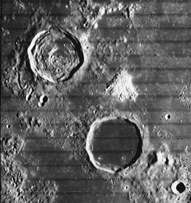
Lunar Orbiter IV image IV-149-H2, Hansteen Alpha aka Mons Hansteen or the Arrowhead, Billy & Hansteen (upper left).
Images
LPOD Photo Gallery Lunar Orbiter Images Apollo Images
Maps
(LAC zone 74C2) LAC map Geologic map
Description
Elger
(IAU Directions) HANSTEEN.--A somewhat larger ring-plain, with a lower and more irregular rampart, rising on the E. to nearly 3,000 feet above the floor, which is depressed to about the same extent as that of Billy. Both the inner and outer slopes are terraced on the W., where the glacis is traversed by a short, delicate, rill-like valley. There are some bright curved ridges on the floor. On the E. of Billy and Hansteen is a wide inlet of the Oceanus Procellarum, bounded by the Letronne region on the E., and on the S. by lofty highlands. On the surface, not far from the S.E. border of Hansteen, is a curious triangular-shaped mountain mass, with a digitated outline on the S., and including a small bright crater on its area. Between this and the ring- plain is a large but somewhat obscure depression, N. of which lies a rill-like object extending from the N. point of the triangular mountain to the E. wall. At the bottom of a gently sloping valley between Billy and Hansteen is a de
licate marking, which seems to represent a cleft connecting the two formations.
Wikipedia
Additional Information
- IAU page: Hansteen
- Depth data from Kurt Fisher database
- Westfall, 2000: 1.39 km
- Viscardy, 1985: 1.25 km
- Cherrington, 1969: 1.24 km
Nomenclature
- Christopher; Norwegian astronomer (1784-1873).
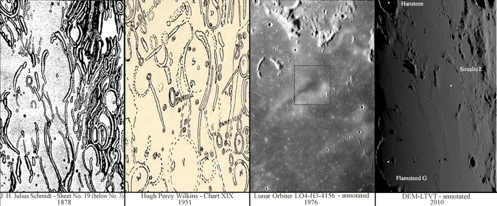
- A Reiner-gamma like surface formation (a swirl) north-northwest of Hansteen (at 7 degrees South, 54 degrees West) was probably called Burrell by Wilkins, and Melloni by Schmidt.
- Burrell-Melloni - a curious case of observation
|
Left: The feature as it appears in Schmidt's map Sheet No. 19. |
- Note: For all images, North is to bottom, East to left (taking into account the pre-1961 cardinal-point changes - see IAU Directions).
- Clearly Schmidt and Wilkins show the feature as a well-marked crater, however, when looked for in the Mädler maps of 1837 and the Neison maps of 1876 Map 12, the feature doesn't appear (Mädler shows it as two small ridge-like or hill-like features, while nothing at all appears on Neison's). Other, more recent mappers have also commented about the feature's appearance/disappearance, which further confused matters, for example, see this 1959 Irish Astronomical Journal article by Larson Milling. - JohnMoore2 ??
- Burrell was a contemporary English selenographer.
- Rimae Hansteen (an unofficial name for the system of rilles on the floor of Hansteen).
LPOD Articles
Bibliography
- Hawke, B. R. et al (2011). Hansteen Alpha: A Silicic Volcanic Construct on the Moon – 42nd LPSC Conference (Mar), 2011.
- Wilkins's "Burrell" and Schmidt's "Melloni": MAPPING AND NAMING THE MOON by Ewen A. Whitaker.
- "Burrell": THE MOON by H.P.Wilkins and P.Moore.
- Milling, L. 1959. Two Lunar Formations - Irish Astronomical Journal, vol. 5(6), p. 173
Named Features -- Prev: Hansen -- Next: Mons Hansteen
