Difference between revisions of "Kircher"
| Line 6: | Line 6: | ||
|} | |} | ||
<div id="toc"> | <div id="toc"> | ||
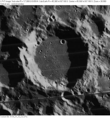
| − | + | [http://www.lpod.org/coppermine/albums/userpics/Kircher_LO-IV-154H_LTVT.JPG [[Image:normal_Kircher_LO-IV-154H_LTVT.JPG|external image normal_Kircher_LO-IV-154H_LTVT.JPG]]]''[http://lpod.org/coppermine/displayimage.php?pos=-3141 LO IV-154-H2]'' The 29-km crater touching '''Kircher''''s rim in the upper right is '''Kircher A'''. On the left, 39-km '''Kircher D''' is the lower part of the deeply shadowed peanut-like structure. In the lower right, 69-km [[Wilson|Wilson]] touches '''Kircher''''s rim at the 5 o'clock position.<br /> <br /> | |
| − | |||
==Images== | ==Images== | ||
[http://www.lpod.org/coppermine/thumbnails.php?album=search&type=full&search=Kircher LPOD Photo Gallery] [http://www.lpi.usra.edu/resources/lunar_orbiter/bin/srch_nam.shtml?Kircher%7C0 Lunar Orbiter Images] [http://planetarynames.wr.usgs.gov/images/Lunar/lac_136.pdf USGS Nomenclature map] (PDF)<br /> <br /> | [http://www.lpod.org/coppermine/thumbnails.php?album=search&type=full&search=Kircher LPOD Photo Gallery] [http://www.lpi.usra.edu/resources/lunar_orbiter/bin/srch_nam.shtml?Kircher%7C0 Lunar Orbiter Images] [http://planetarynames.wr.usgs.gov/images/Lunar/lac_136.pdf USGS Nomenclature map] (PDF)<br /> <br /> | ||
| Line 35: | Line 34: | ||
<br /> <br /> | <br /> <br /> | ||
---- | ---- | ||
| − | + | </div> | |
Revision as of 16:29, 15 April 2018
Contents
Kircher
|
Lat: 67.1°S, Long: 45.3°W, Diam: 72 km, Depth: 4.4 km, Rükl: 71 |

Images
LPOD Photo Gallery Lunar Orbiter Images USGS Nomenclature map (PDF)
Maps
(LAC zone 136B2) USGS Digital Atlas PDF
Description
Description: Elger
(IAU Directions) KIRCHER.--A ring-plain, about 45 miles in diameter, S. of Bettinus, remarkable also for its very lofty rampart, which on the S. attains the tremendous height of nearly 18,000 feet above the floor, which appears to be devoid of detail.
Description: Wikipedia
Additional Information
- Depth data from Kurt Fisher database
- Westfall, 2000: 4.4 km
- Viscardy, 1985: 3.3 km
- Cherrington, 1969: 4.69 km
- Satellite crater Kircher A is on the ALPO list of banded craters
Nomenclature
- Named for Athanasius Kircher (May 2, 1602 - November 27, 1680), a German Jesuit scholar who published around 40 works, most notably in the fields of oriental studies, geology and medicine. One of the first people to observe microbes through a microscope, he was thus ahead of his time in proposing that the plague was caused by an infectious microorganism and in suggesting effective measures to prevent the spread of the disease. Kircher has been compared to Leonardo da Vinci for his inventiveness and the breadth and depth of his work. A scientific star in his day, towards the end of his life he was eclipsed by the rationalism of René Descartes and others. In the late 20th century, however, the aesthetic qualities of his work again began to be appreciated. One scholar, Edward W. Schmidt, has called him "the last Renaissance man".
- According to Whitaker (p. 211), this was one of the original names from Riccioli's map, where it was listed as Kircher Soc. I (the "Soc. I" standing for "Society of Jesus" -- see the list of Jesuit astronomers).
LPOD Articles
Bibliography