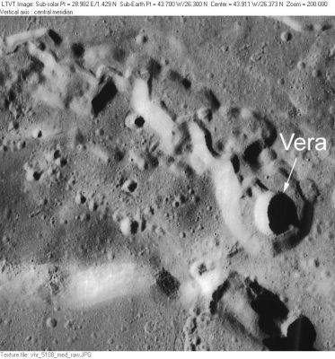
Vera
Contents
Vera
(formerly Prinz A)
|
Lat: 26.3°N, Long: 43.7°W, Diam: 2 km, Depth: 0.56 km, Rükl: 19 |
LO-V-188M Vera is just north of Prinz (whose rim is partially visible at the bottom), and lies at one end of one of the several sinuous rilles comprising Rimae Prinz. About 20-km to the NNE is another named pit, Ivan. A little stream-like winding channel (about 400 m wide) meandering down the floor of the main rima seems to originate at Vera. A very similar structure (also with a little meandering stream) can be seen in the Cobra Head area of Schröter’s Valley.
Images
LPOD Photo Gallery Lunar Orbiter Images Apollo Images
Vera was also captured on Apollo 15's orbital ITEK-panoramic frames AS15-P-10316 and 10321.
Research: Danny Caes
Maps
(LAC zone 39A3) LAC map Geologic map LM map LTO Topophotomap
Description
Description: Wikipedia
Additional Information
Depth data from Kurt Fisher database
- Westfall, 2000: 0.56 km
- Viscardy, 1985: 0.18 km
Nomenclature
Latin female name.
- According to NASA RP-1097, "Vera" is a Minor Feature whose name was originally intended only for use in connection with Topophotomap 39A3/S1(on which it is plotted).
- Somewhere in the solar system, an object called Vera is strolling her way through the main belt of the asteroids, see 245 Vera- DannyCaes Mar 24, 2013
LPOD Articles
Bibliography
