Rimae Theaetetus
Contents
Rimae Theaetetus (I, II, and III)
|
Lat: 33.0°N, Long: 6.0°E, Length: 50 km, Depth: km, Rükl: 12 |
LO-IV-103H
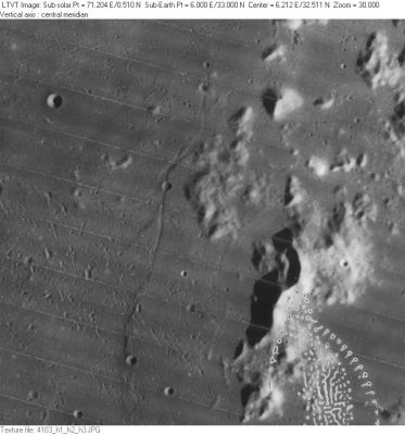
Rimae Theaetetus I and II are the names for the rilles near the middle of this frame. The 5-km circular crater in the upper left is Aristillus A. Near the bottom, 3-km Autolycus K is astride the ridge that seems to extend south from one of the rilles. The hills on the right are the southern part of Montes Caucasus. None of the other features in this area of eastern Mare Imbrium have individual names. Rima Theaetetus III is not captured in this frame because its location is west of Theaetetus itself.
Images
LPOD Photo Gallery Lunar Orbiter Images Apollo Images
Maps
(LAC zone 25C3) LAC map Geologic map
Description
Description: Wikipedia
Additional Information
There's a system of shallow rilles about halfway between the southern part of Montes Caucasus and Autolycus K. Is this system also known as Rimae Theaetetus?
Nomenclature
Named from nearby crater. (Theaetetus)
- Two Roman-numeralled rilles associated with Theaetetus were part of the original IAU nomenclature of Blagg and Müller. Exactly when the name in its present form was adopted is unclear. - Jim Mosher
- According to Chart C2 of the SLC (System of Lunar Craters), the locations of both Rimae Theaetetus I and II are west of the most southern part of Montes Caucasus. The location of Rima Theaetetus III is west of Theaetetus itself (south of Cassini, at Palus Nebularum). See also Charts 18 and 19 in the Times Atlas of the Moon.
LPOD Articles
Bibliography
