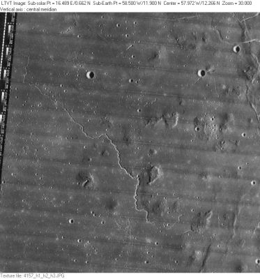
Rima Galilaei
Contents
Rima Galilaei
|
Lat: 11.9°N, Long: 58.5°W, Length: 89 km, Depth: km, Rükl: 28 |
LO-IV-157H Rima Galilaei extends from upper left to lower right. The rilles in the upper right corner are unnamed.
Images
LPOD Photo Gallery Lunar Orbiter Images Apollo Images
Maps
(LAC zone 56B4) LAC map Geologic map
Description
Description: Wikipedia
Additional Information
Nomenclature
- Named from nearby crater Galilaei.
- Number 29 in Debra Hurwitz's Atlas and Catalog of Sinuous Rilles.
- Not named on Chart 36 in the Times Atlas of the Moon.
- The two pronounced rilles in the upper right corner of the frame above are not named. Why not? One of the two is the "home" of a recently discovered skylight (an unusual pit, not at all looking like a common lunar crater). The nearest one of the officially named craters is Galilaei M. Perhaps we could call these two rilles Rimae Galilaei M?). An LROC close-up of the Galilaei M rilles: http://bit.ly/2zkfxET
- Speaking of Galilaei M. Very near this bowl-shaped crater (southeast and southwest of it) there are two small rilles which look more like chains of small depressions. So... what are they really? Rilles? Chains? Or a combination of the two?
- An LROC close-up of Galilaei M and its to nearby rilles / chains: http://bit.ly/2iOS7k6
LPOD Articles
Bibliography
