Rima Draper
Contents
[hide]Rima Draper
|
Lat: 18.0°N, Long: 25.0°W, Length: 160 km, Depth: km, Rükl: 20 |
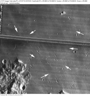
LO-IV-126H Rima Draper was very faintly recorded at the positions of the white arrows in this Lunar Orbiter view (click on the image to see a larger version).
Note: in this image, the rough terrain at lower left was once known as Promontorium Banat (thus named by J.N.Krieger). The small hillock at upper right (Pytheas Beta) was once known as Mount Dyson (thus named by H.P.Wilkins).- DannyCaes Feb 3, 2014
Images
LPOD Photo Gallery Lunar Orbiter Images Apollo Images
- Rima Draper is prominently visible in the middle foreground of Apollo 17 Hasselblad image AS17-139-21291, taken looking south over the Carpathian Mountains and T. Mayer. A higher resolution scan of this image can be found in the Apollo 17 Lunar Surface Journal Image Library. - Jim Mosher
Maps
(LAC zone 40D4) LAC map Geologic map
Description
Description: Wikipedia
Additional Information
Could this be the western continuation of Rima Draper? (the arc shaped rille-like section west of the bowl-shaped crater Tobias Mayer K), see: http://bit.ly/2iNnCuW
Nomenclature
Named from nearby crater Draper
  Number 93 in Debra Hurwitz's Atlas and Catalog of Sinuous Rilles.
 Rima Draper is not known on Chart 26 in the Times Atlas of the Moon.
LPOD Articles
Wonder Rille; Come Out on the Balcony for a Better View
Bibliography
