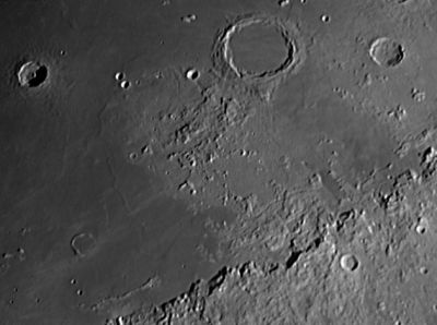
Montes Archimedes
Contents
[hide]Montes Archimedes (aka Montes Lomonosov)
|
Lat: 25.3°N, Long: 4.6°W, Diam: 163 km, Height: km, Rükl: 22 |

Peter Lloyd
Montes Archimedes is the rough terrain south-southwest of the large crater Archimedes.
Images
LPOD Photo Gallery Lunar Orbiter Images Apollo Images (see page Archimedes)
- Apollo 15's post-sunrise Fairchild camera photograph AS15-M-0421 shows almost the whole of Montes Archimedes. Note the arc-like tendency of the three main components of these mountains. It's as if this interrupted ring's centre is located somewhere near the upper right corner of the frame (only one fifth of the complete ring structure is visible).
- Research: Danny Caes
Maps
(LAC zone 41A3) LAC map Geologic map LM map LTO map
Description
Description: Wikipedia
Additional Information
Nomenclature
- Named from nearby crater. (Archimedes)
- In an informal tour of Mare Imbrium, Montes Archimedes was referred to as the Hill Country (Copeland, 1953). Research: Danny Caes
- Another unofficial name was Montes Lomonosov. This name is mentioned in the book THE MOON by A.V.Markov. Research: Danny Caes
LPOD Articles
Bibliography