Menelaus
Contents
[hide]Menelaus
|
Lat: 16.23°N, Long: 15.92°E, Diam: 26.91 km, Depth: 2.6 km, Rükl 23 |


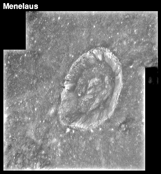
Left: Apollo 15 - high Sun.
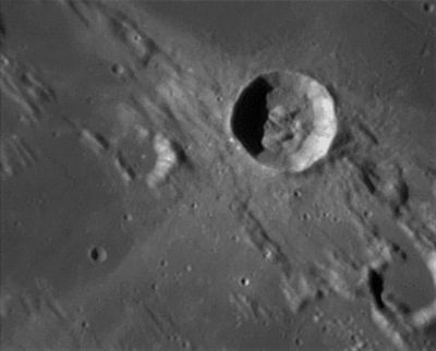
Right: François Emond: Menelaus with Daubrée to its left and Auwers in the lower right
Images
LPOD Photo Gallery Lunar Orbiter Images Apollo Images ASU Apollo Image Archive
- Several southward-looking frames made by Apollo 17's mapping/metric Fairchild camera show weak reflected light on the shadowed eastern inner slopes of high-albedo crater Menelaus. Perhaps the best frame to explore Menelaus's shadowed slopes is the Arizona State University's zoomify-scan of AS17-M-1667. In this frame, Menelaus was captured near the right margin. While exploring, please zoom in at maximum, to get a real close-up of Menelaus's shadowed (and vaguely illuminated) inner slopes!
- Research: Danny Caes
Maps
(LAC zone 42D3) LAC map Geologic map LM map LTO map
Description
Elger
(IAU Directions) MENELAUS.--A conspicuously bright regular ring-plain, about 20 miles in diameter, situated on the S. coast-line of the Mare Serenitatis, and closely associated with the Haemus range. It has a brilliant central mountain, but no visible detail on the walls. On the edge of the Mare, S.E. of it, there is a curious square formation. The bright streak traversing the Mare from N. to S., which is so prominently displayed in old maps of the moon, passes through this formation.
Wikipedia
Additional Information
- IAU page: Menelaus
- Depth data from Kurt Fisher database
- Pike, 1976: 2.6 km
- Arthur, 1974: 3.02 km
- Westfall, 2000: 2.6 km
- Viscardy, 1985: 3 km
- Cherrington, 1969: 2.65 km
- East rim slope 53° (Pohn, 1963)
- Thermal anomaly crater, implying youthful age - Moore et al, 1980
- Included in ALPO list of bright ray craters
- Included on the ALPO list of banded craters
- TSI = 15, CPI = 10, FI = 15; MI =40 Smith and Sanchez, 1973
- The LROC's high-resolution NAC photographs of Menelaus A (west of Menelaus itself) show a peculiar system of two parallel high-albedo stripes (rays) on the western part of its inner slopes. - DannyCaes Aug 16, 2014
Nomenclature
- Named for Menelaus, in Greek mythology a king of Ancient Sparta, the husband of Helen, and a central figure in the Trojan War.
- This name has continued unchanged since its original usage for this feature on Riccioli's map (Whitaker, p. 213).
- Menelaus Zeta (dome-like elevation north of Menelaus) (see Chart 30 in the Times Atlas of the Moon).
The Bessel Ray (is Menelaus the source?)
The 21st Century Atlas of the Moon (Charles A. Wood/ Maurice J.S. Collins) is perhaps the very first lunar atlas which has a name for the mysterious high-albedo ray running across Mare Serenitatis, crater Bessel, and crater Menelaus. This ray is one of the most stubborn riddles in the history of moon observing and selenography.
  What is the source of this remarkable singular ray of ejecta? Is Bessel the source? Or is it a crater to the north of Mare Serenitatis? Or perhaps crater Menelaus at the southern rim of Mare Serenitatis?
  It's very strange that this kind of pronounced rays (ejecta rays from impact craters) don't have official IAU names.
  Anyway, Chart 11 (page 35) in the 21st Century Atlas of the Moon shows the informal name Bessel Ray just north of crater Bessel.
  How many (ancient or recent) moonbooks have a description of the mysterious Bessel Ray in Mare Serenitatis?
 - DannyCaes Aug 16, 2015
LROC Articles
LPOD Articles
Bibliography
- Yamamoto, A. (2011). Remote Sensing Data Analysis for the Menelaus Region of the Moon – 42nd LPSC Conference (Mar), 2011.
- Yamamoto, A. and others (2012). Kaguya LISM/MI Data Analysis for the Menelaus Region of the Moon - 43rd LPSC, #1449.
- Apollo Image of the Week - Menelaus' Distinctive Rays
Named Features -- Prev: Catena Mendeleev -- Next: Rimae Menelaus