Lansberg
Contents
Lansberg
(current IAU name; former IAU spelling: Landsberg)
|
Lat: 0.3°S, Long: 26.6°W, Diam: 38 km, Depth: 2.75 km, Rükl: 42, Upper Imbrian |

Images
LPOD Photo Gallery Lunar Orbiter Images Apollo Images (see also: Lansberg, south of and Lansberg B area)
- Lunar orbiter stereo view
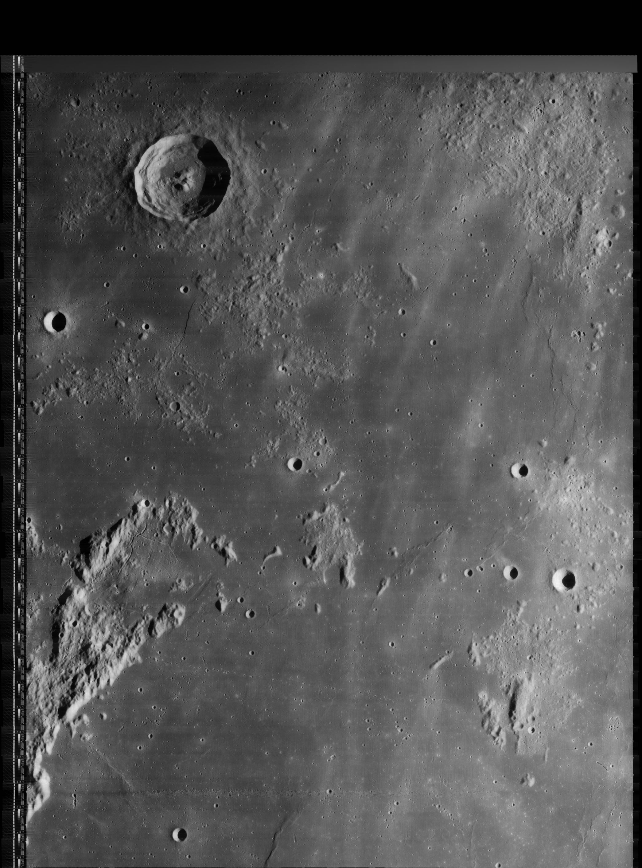
- Apollo 12 orbital photograph AS12-54-8097 shows Lansberg C (Lamech's Rudaux) at right, and Lansberg G slightly north-northwest of it. Immediately west of Lansberg G (touching the western part of Lansberg G's rim) is the irregular shaped depression Lansberg GA, which was depicted by Antonin Rukl as a common looking craterlet on his Chart 41. This irregular shaped depression (Lansberg GA) is an interesting telescopic target for every dedicated observer of the Lansberg region. Research: Danny Caes.
Maps
(LAC zone 76A1) LAC map Geologic map LM map AIC map
USGS Geologic Map of the Lansberg P region (I-627), (including the landing sites of Surveyor 3 and Apollo 12)
Powered Descent Initiation-PDI map of the surrounding region of Lansberg (with Greek-lettered hillocks) (source: ALSJ, Apollo 12).
Description
Description: Elger
(IAU Directions) LANDSBERG.--A ring-plain, about 28 miles in diameter, situated in Mare Nubium, S.W. of Reinhold, which in many respects it resembles. Its regular massive border is everywhere continuous. Only a solitary crater breaks the uniformity of its crest, that rises on the E. to nearly 10,000 feet, and on the W. to about 7,000 feet above the floor, which is depressed about 7,000 feet below the surrounding surface. The inner slopes exhibit some fine terraces, and on the broad E. glacis is a curious winding valley, which runs up the slope from the S.E. side to the crater just mentioned, then, bending downwards, joins the plain at the foot of the N. wall. Neither this nor the crater is shown in the maps. The large compound central peak is apparently the sole object in the interior. At 8 h. 25 m. on January 23, 1888, when observing the progress of sunrise on this formation with a 8 1/2 inch Calver-reflector charged with different eyepieces, I noticed, when about three-fourths of the floor was in shadow, that the illuminated portion of it was of a dark chocolate hue, strongly contrasting with the grey tone of the surrounding district. This appearance lasted till the interior was more than half illuminated, gradually becoming less pronounced as the sun rose higher on the ring. W. and S.W. of Landsberg is a number of ring-plains and craters well worthy of careful examination. Five of the largest are surrounded by a glistening halo, and one (that nearest to the formation) and another (the largest of the group) have each a minute crater on their N. wall.
Description: Wikipedia
Lansberg
Did Luna 5 really came down southeast of Lansberg? The Wikipedia page of Luna 5 shows a totally different location.
Apollo 13's S-IVB stage impacted near Lansberg B south-southwest of Lansberg itself.
Additional Information
- Depth data from Kurt Fisher database
- Pike, 1976: 2.75 km
- Arthur, 1974: 3.11 km
- Westfall, 2000: 2.75 km
- Viscardy, 1985: 3.11 km
- Cherrington, 1969: 3.32 km
- Central peak composition: GNTA1, GNTA2 & AGN (Tompkins & Pieters, 1999)
- Satellite craters Lansberg A and B are on the ALPO list of bright ray craters.
- Satellite craters Lansberg B and D are on the ALPO list of banded craters
- Lansberg D is a thermal anomaly crater, implying a youthful age - Moore et al, 1980
- TSI = 30, CPI = 15, FI = 20; MI =65 Smith and Hartnell, 1973
- Lansberg GA is an irregular shaped depression immediately west of Lansberg G- DannyCaes Sep 16, 2009
- Curious Rupes Recta like scarp south of Lansberg, discovered by Brian Albin of Oregon on Lunar Orbiter 4 frame 125-h3 (source: Michael Wirths), see also LPOD 50 Year Uncertainty., and Apollo 14's Hasselblad frames AS14-73-10120 to 10125 in Magazine 73-M.
Nomenclature
- Named for Johan Philip Lansberge (August 25, 1561 – December 8, 1632), a Dutch astronomer. He is best known as the author of a set of astronomical tables, Tabulae motum coelestium, for predicting planetary positions. These were later found to contain certain errors, in part because he erroneously did not accept Kepler's discovery of elliptical orbits.
- According to Whitaker (p. 213), this name appeared as Lansbergius on Riccioli's map; however, in her Collated List (1913) Mary Blagg found all three of her authorities spelling it Landsberg, and it was adopted into the original IAU nomenclature of Named Lunar Formations in that form. G. P. Kuiper attributed this spelling to an "error by Mayer" in Table III of his Photographic Lunar Atlas, and proposed changing the spelling to Lansberg, a recommendation which was adopted by the IAU in 1961, although the old spelling Landsberg can be found in IAU Transactions as late as 1973 (in the list of recommended control points. - Jim Mosher
- Lansberg Beta (hill east-southeast of Lansberg).
- Lansberg Eta (hill south-southeast of Lansberg).
- Lansberg Sigma (hill east-southeast of Lansberg, much more eastward beyond Lansberg Beta) (for the hills Lansberg Beta, Eta, and Sigma, see Chart 53 in the Times Atlas of the Moon).
- Lansberg Omega (?) (hill south-southwest of Lansberg, east of Lansberg B).
- Felix Chemla Lamèch suggested the names Rudaux for Lansberg C and Schlumberger for Lansberg D. Lucien Rudaux was a pioneer of Space Art and author of the book Sur les Autres Mondes. René Schlumberger was a lunar observer noted for an early drawing of the dome field near Hortensius. Neither of these names (Rudaux or Schlumberger) was accepted by the IAU. -- (research: Ewen A. Whitaker and Danny Caes; August 2003, mail correspondence).
- Bibendum (Michelin Man) is Danny Caes's nickname for a human-like cluster of craterlets east of Lansberg. This Bibendum was captured on Lunar Orbiter 1's frame 151-med (near the lower left corner of the photograph), and also on 149-med (near the lower right corner).- DannyCaes Mar 12, 2014
LPOD Articles
50 Years Uncertainty (the case of the curious fault/rille south of Lansberg).
Bibliography
- Lamech's Rudaux and Schlumberger: Whitaker, Ewen A. Mapping and Naming the Moon.