Langemak
Contents
Langemak
| Lat: 10.3°S, Long: 118.7°E, Diam: 97 km, Depth: km, Rükl: (farside) |

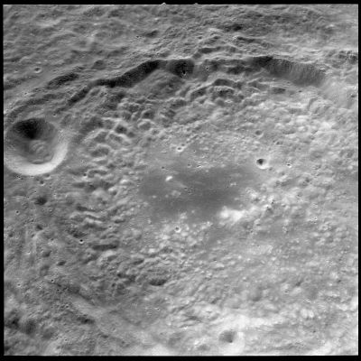
Apollo 17 image AS17-151-23240 Langemak is partially visible in this westward looking view, with the 18-km crater Sherrington on its southwest rim.
Images
LPOD Photo Gallery Lunar Orbiter Images Apollo Images
- The dark lacus-like region on the floor of Langemak was frequently photographed during the mission of Apollo 8. One of these photographs is AS8-17-2744, which was made during typical "shadowless-circumstances" (very high sun).
- Research: Danny Caes
- HiRes scan of Apollo 8 photograph: David Woods and Frank O'Brien (Apollo 8 Flight Journal).
Maps
(LAC zone 83D2) LTO map
IAU page: Langemak
Description
Description: Wikipedia
Additional Information
Nomenclature
- Named for Georgy Erikhovich Langemak (June 26, 1898 – January 11, 1938), a Soviet rocket designer of Swedish background. He is chiefly remembered for being the co-designer (with Sergei Korolev) and directing the development of the Katyusha rocket launcher that was used with such success during World War II.
- Langemak was among the long list of farside names approved by the IAU in 1970 and published in Menzel, 1971.
- In the planning for Apollo 8, the first manned circumlunar mission (1968), this crater (which did not then have an official name) was referred to informally as "Armstrong", a name presently in use for a completely different nearside crater (see: Phil Stooke's LPOD). Langemak N, immediately south of Langemak, was informally known as "Aldrin", again a name that is presently used to designate a completely different nearside crater.
LPOD Articles
- see also: Langemak Crater: Window Into the Ancient Lunar Crust -- Apollo Image Archive Lunar Image of the Week
Bibliography