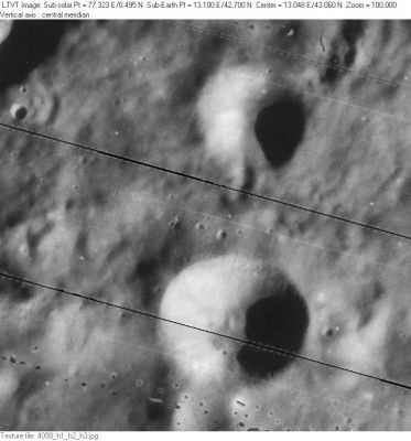
Lamèch
Contents
Lamèch
| Lat: 42.7°N, Long: 13.1°E, Diam: 13 km, Depth: 1.46 km, Rükl: 13 |
LO-IV-098H Lamèch is at the bottom. The 10-km crater above it is Eudoxus D. The shadowed ridge in the upper left corner is a very small part of the western flank of Montes Caucasus.
Images
LPOD Photo Gallery Lunar Orbiter Images
Maps
(LAC zone 26A4) LAC map Geologic map
Description
Description: Wikipedia
Additional Information
- Depth data from Kurt Fisher database
- Westfall, 2000: 1.46 km
- Viscardy, 1985: 1.46 km
- From the shadows in LO-IV-108H, Lamèch is 1430-1900 m deep. - Jim Mosher
- The "L"-shaped mountain at 43° north/ 11° east (the Lamech plateau; west of Lamech, in the northern part of the Montes Caucasus) is an interesting telescopic target during Full Moon, when the western slope of its north-south oriented part, and the southern slope of its east-west oriented part, look very much like an illuminated "L" or "sunlit corner". It is unofficially called Mons Elbruz by Danny Caes (note: the Terrestrial Mount Elbruz is also located in the Caucasus range). - DannyCaes Jan 23, 2008
Nomenclature
- Named for Felix Chemla Lamèch (1894-1962), a French selenographer and founder and first director of Corfu Observatory. See the extended biography.
- Named by Karl Müller in Named Lunar Formations in 1935 (Whitaker, p 229). According to Whitaker (p. 228), Lamèch had previously named a crater after Müller.
LPOD Articles
Bibliography
