Dorsum Grabau
Contents
Dorsum Grabau
|
Lat: 29.4°N, Long: 15.9°W, Length: 121 km, Height: km, Rükl: 21 |
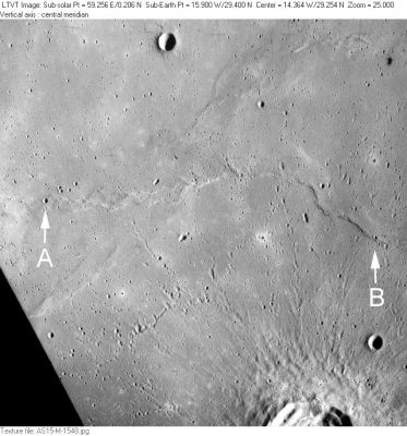
AS15-M-1548 Dorsum Grabau extends across the middle of this rectified Apollo 15 Metric Camera view, from “A” to “B”. Other IAU-named features include the 1-km crater Sampson at “A” and the 6-km crater Landsteiner at the top. The 33-km crater partially visible along the bottom margin is Timocharis , and the 5-km circular crater to its upper right is Timocharis B. The ridge below “A” is the northeastern part of Dorsum Higazy. Among the many crater pits, one particular group, extending south from Dorsum Grabau was singled out for naming: Catena Timocharis.
Images
LPOD Photo Gallery Lunar Orbiter Images Apollo Images
Maps
(LAC zone 40B1) LAC map Geologic map LTO map
Description
Description: Wikipedia
Additional Information
Nomenclature
Amadeus William; American paleontologist (1870-1946).
- Dorsum Grabau was among the many provisional dorsa names appearing on NASA’s LTO charts that were approved by the IAU “as now assigned and printed” (on those charts) in IAU Transactions XVIB. It is labeled on LTO-40B1 and LTO-40B2.
- The diameter currently listed for Dorsum Grabau in the on-line IAU Planetary Gazetteer (and repeated on the title line of this page) seems about right, but appears to be positioned much to far to the west, being centered nearly on Sampson, at the extreme western end of the ridge named on the LTO's.
LPOD Articles
Bibliography
