Dorsa Cato
Contents
Dorsa Cato
|
Lat: 1.0°N, Long: 47.0°E, Length: 140 km, Height: km, Rükl: 37 |
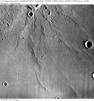
LO-I-031M Dorsa Cato are the ridge(s ?) slightly to the left of center in this view which includes Catena Taruntius in the upper right, and Anville a little above the center right margin. The ridges just below Anville are part of Dorsum Cushman. The prominent ridge in the lower right might possibly be part of Dorsa Cato, but no name is assigned to it on LTO-79B2 (where it appears), so it is most likely unnamed .
Images
LPOD Photo Gallery Lunar Orbiter Images Apollo Images
Maps
(LAC zone 61C3) LAC map Geologic map AIC map LTO map
Description
Description: Wikipedia
Additional Information
See also NASA's Gemini Ridge.
Nomenclature
Marcus Porcius; Roman geological engineer (234-149 B.C.).
- Dorsa Cato was among the feature names approved "as now assigned and printed on the 1:250,000 lunar map series" (LTO's) in 1976 (IAU Transactions XVIB). The name appeared provisionally on LTO-61C3. The name was applied only to the single prominent ridge to the southwest of the linear depression near the center of the image shown above. There is a strong suspicion that the LTO map maker confused the Latin "dorsa" with "dorsum", using the plural form (dorsa) for isolated ridges and the singular form (dorsum) for groups of ridges. - Jim Mosher
LPOD Articles
Bibliography
