Difference between revisions of "Rima Sharp"
| (3 intermediate revisions by the same user not shown) | |||
| Line 3: | Line 3: | ||
{| class="wiki_table" | {| class="wiki_table" | ||
| | | | ||
| − | Lat: 46.7°N, Long: 50.5°W, Length: 107 km, Depth: 0.05-0.30 km, [ | + | Lat: 46.7°N, Long: 50.5°W, Length: 107 km, Depth: 0.05-0.30 km, [[R%C3%BCkl%209|Rükl: 9]]<br /> |
|} | |} | ||
<div id="toc"> | <div id="toc"> | ||
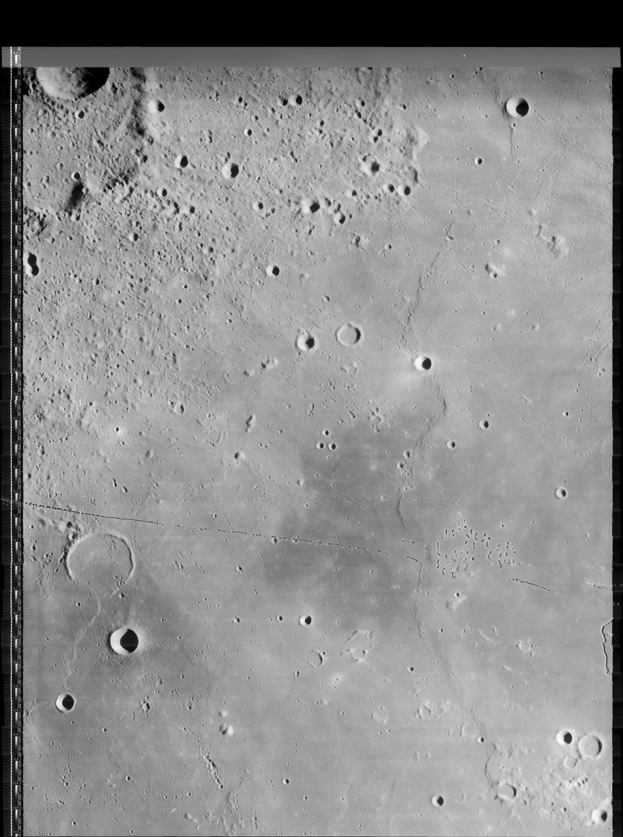
| − | + | [http://www.lpod.org/coppermine/albums/userpics/Rima%20Sharp_LO-IV-158H_LTVT.JPG [[Image:Normal_Rima%20Sharp_LO-IV-158H_LTVT.JPG|external image normal_Rima%20Sharp_LO-IV-158H_LTVT.JPG]]]<br /> ''[http://lpod.org/coppermine/displayimage.php?pos=-2806 LO-IV-158H]'' '''Rima Sharp''' runs along the entire left-hand side of this [[Lunar%20Orbiter|Lunar Orbiter]] view and continues for some distance out of the frame to the south. The 21-km crater Sharp B is in the upper right. A portion of the hilly area in the lower right corner is designated by the IAU as the 36-km crater [[Louville|Louville]]. Some of the craters to the west of '''Rima Sharp''' are [[lettered%20crater|lettered craters]] named after [[Louville|Louville]].<br /> <br /> | |
| − | |||
==Images== | ==Images== | ||
| − | [http://www.lpod.org/coppermine/thumbnails.php?album=search&type=full&search=Rima%20Sharp LPOD Photo Gallery] [http://www.lpi.usra.edu/resources/lunar_orbiter/bin/srch_nam.shtml?Rima%20Sharp%7C0 Lunar Orbiter Images] [http://www.lpi.usra.edu/resources/apollo/search/feature/?feature=Rima%20Sharp Apollo Images] '''Warning''': [http://www.lpi.usra.edu/resources/apollo/frame/?AS15-95-12870 AS15-95-12870] doesn't show '''Rima Sharp''', it's '''Rima Mairan'''.<span class="membersnap">- | + | [http://www.lpod.org/coppermine/thumbnails.php?album=search&type=full&search=Rima%20Sharp LPOD Photo Gallery] [http://www.lpi.usra.edu/resources/lunar_orbiter/bin/srch_nam.shtml?Rima%20Sharp%7C0 Lunar Orbiter Images] [http://www.lpi.usra.edu/resources/apollo/search/feature/?feature=Rima%20Sharp Apollo Images] '''Warning''': [http://www.lpi.usra.edu/resources/apollo/frame/?AS15-95-12870 AS15-95-12870] doesn't show '''Rima Sharp''', it's '''Rima Mairan'''.<span class="membersnap">- DannyCaes <small>Oct 19, 2010</small></span><br /> <br /> |
==Maps== | ==Maps== | ||
| − | ''([ | + | ''([[LAC%20zone|LAC zone]] 23A2)'' [http://www.lpi.usra.edu/resources/mapcatalog/LAC/lac23/ LAC map] [http://www.lpi.usra.edu/resources/mapcatalog/usgs/I805/ Geologic map] [http://planetarynames.wr.usgs.gov/images/Lunar/lac_23.pdf USGS Digital Atlas (PDF)]<br /> <br /> |
==Description== | ==Description== | ||
<br /> | <br /> | ||
| Line 17: | Line 16: | ||
[http://en.wikipedia.org/wiki/Rima_Sharp Rima Sharp]<br /> <br /> | [http://en.wikipedia.org/wiki/Rima_Sharp Rima Sharp]<br /> <br /> | ||
==Additional Information== | ==Additional Information== | ||
| − | * Despite the drastic changes in appearance along its length, [http://www.lpi.usra.edu/resources/lunarorbiter/frame/?4158 LO-IV-158H] indicates that '''Rima Sharp''' has a fairly constant width. In one short stretch to the west of '''[ | + | * Despite the drastic changes in appearance along its length, [http://www.lpi.usra.edu/resources/lunarorbiter/frame/?4158 LO-IV-158H] indicates that '''Rima Sharp''' has a fairly constant width. In one short stretch to the west of '''[[Mairan|Mairan]] T''' (not shown above) it broadens to about 3 km in width, and in the northernmost extension it is about 700 m wide; but most everywhere else the width is close to 1.1 km. As to depth, in the strongly lit section between the headlands, the shadows suggest the depth decreases steadily from about 300 m in the north to about 200 m in the south. The long, faint southern extension looks much shallower. It has the appearance of a flat-bottomed channel with walls no more than 50-70 m high. <span class="membersnap">- JimMosher</span> |
| − | * Curious little chain of three depressions to the west of '''Rima Sharp''' (at approximately 52° West/ 46° North). See the lower right corner of [http://www.lpi.usra.edu/resources/lunarorbiter/images/preview/4170_h3.jpg LO-IV-170-h3]. It looks a bit like the little chain at '''Encke M''' (the triplet to the east of '''Encke''' itself). <span class="membersnap">- | + | * Curious little chain of three depressions to the west of '''Rima Sharp''' (at approximately 52° West/ 46° North). See the lower right corner of [http://www.lpi.usra.edu/resources/lunarorbiter/images/preview/4170_h3.jpg LO-IV-170-h3]. It looks a bit like the little chain at '''Encke M''' (the triplet to the east of '''Encke''' itself). <span class="membersnap">- DannyCaes <small>Aug 7, 2014</small></span> |
<br /> | <br /> | ||
==Nomenclature== | ==Nomenclature== | ||
| − | * Named after the nearby crater. ([ | + | * Named after the nearby crater. ([[Sharp|Sharp]]) |
* Number 85 in Debra Hurwitz's Atlas and Catalog of Sinuous Rilles (together with '''Rima Mairan'''). | * Number 85 in Debra Hurwitz's Atlas and Catalog of Sinuous Rilles (together with '''Rima Mairan'''). | ||
| − | * The [ | + | * The [[IAU%20Planetary%20Gazetteer|IAU Planetary Gazetteer]] gives an approval date of 1964 for '''Rima Sharp''' (and many other rimae). This is apparently a reference to their depiction on the [[Quad%20Maps|Quad Maps]] of the ''[[System%20of%20Lunar%20Craters|System of Lunar Craters]]''. A rille labeled '''Sharp I''' appears on [http://www.glrgroup.org/domes/mapdome/e2.htm Sheet E2] (not actually published until 1967?). It extends only over the short deeply incised segment in the upper part of the Lunar Obiter photo. On [http://www.lpi.usra.edu/resources/mapcatalog/LAC/lac23/ LAC-23] (February 1967), the label for '''Rima Sharp I''' is extended along the fainter length to the south, and it is depicted that way on the new [[USGS%20Digital%20Atlas|USGS Digital Atlas]] page. However the position and diameter listed in the [[IAU%20Planetary%20Gazetteer|IAU Planetary Gazetteer]] (and copied into the title line of the present page) correspond only to the short segment depicted in the ''[[System%20of%20Lunar%20Craters|System of Lunar Craters]]''. A more accurate length would be about 270 km (roughly 250 km directly from start to finish, or about 335 km following the major bends). <span class="membersnap">- JimMosher</span> |
<br /> | <br /> | ||
==LPOD Articles== | ==LPOD Articles== | ||
| Line 31: | Line 30: | ||
<br /> <br /> | <br /> <br /> | ||
---- | ---- | ||
| − | + | </div> | |
Latest revision as of 21:39, 16 April 2018
Contents
Rima Sharp
|
Lat: 46.7°N, Long: 50.5°W, Length: 107 km, Depth: 0.05-0.30 km, Rükl: 9 |

LO-IV-158H Rima Sharp runs along the entire left-hand side of this Lunar Orbiter view and continues for some distance out of the frame to the south. The 21-km crater Sharp B is in the upper right. A portion of the hilly area in the lower right corner is designated by the IAU as the 36-km crater Louville. Some of the craters to the west of Rima Sharp are lettered craters named after Louville.
Images
LPOD Photo Gallery Lunar Orbiter Images Apollo Images Warning: AS15-95-12870 doesn't show Rima Sharp, it's Rima Mairan.- DannyCaes Oct 19, 2010
Maps
(LAC zone 23A2) LAC map Geologic map USGS Digital Atlas (PDF)
Description
Description: Wikipedia
Additional Information
- Despite the drastic changes in appearance along its length, LO-IV-158H indicates that Rima Sharp has a fairly constant width. In one short stretch to the west of Mairan T (not shown above) it broadens to about 3 km in width, and in the northernmost extension it is about 700 m wide; but most everywhere else the width is close to 1.1 km. As to depth, in the strongly lit section between the headlands, the shadows suggest the depth decreases steadily from about 300 m in the north to about 200 m in the south. The long, faint southern extension looks much shallower. It has the appearance of a flat-bottomed channel with walls no more than 50-70 m high. - JimMosher
- Curious little chain of three depressions to the west of Rima Sharp (at approximately 52° West/ 46° North). See the lower right corner of LO-IV-170-h3. It looks a bit like the little chain at Encke M (the triplet to the east of Encke itself). - DannyCaes Aug 7, 2014
Nomenclature
- Named after the nearby crater. (Sharp)
- Number 85 in Debra Hurwitz's Atlas and Catalog of Sinuous Rilles (together with Rima Mairan).
- The IAU Planetary Gazetteer gives an approval date of 1964 for Rima Sharp (and many other rimae). This is apparently a reference to their depiction on the Quad Maps of the System of Lunar Craters. A rille labeled Sharp I appears on Sheet E2 (not actually published until 1967?). It extends only over the short deeply incised segment in the upper part of the Lunar Obiter photo. On LAC-23 (February 1967), the label for Rima Sharp I is extended along the fainter length to the south, and it is depicted that way on the new USGS Digital Atlas page. However the position and diameter listed in the IAU Planetary Gazetteer (and copied into the title line of the present page) correspond only to the short segment depicted in the System of Lunar Craters. A more accurate length would be about 270 km (roughly 250 km directly from start to finish, or about 335 km following the major bends). - JimMosher
LPOD Articles
Three Rilles and a Strange Volcano
Bibliography