Difference between revisions of "Montes D'Alembert"
| Line 2: | Line 2: | ||
=Montes d'Alembert= | =Montes d'Alembert= | ||
''(discontinued [[IAU|IAU]] name; former IAU name: '''D'Alembert Mountains''')''<br /> <div id="toc"> | ''(discontinued [[IAU|IAU]] name; former IAU name: '''D'Alembert Mountains''')''<br /> <div id="toc"> | ||
| − | + | ||
| − | |||
{| class="wiki_table" | {| class="wiki_table" | ||
| Lat: 7°S, Long: 85°W, Diameter: 310 km, Height: km, Rukl:<br /> | | Lat: 7°S, Long: 85°W, Diameter: 310 km, Height: km, Rukl:<br /> | ||
| Line 44: | Line 43: | ||
Baum, R. and Whitaker, E. A. 2007. [http://adsabs.harvard.edu//abs/2007JBAA..117..129B Mare Orientale: The Eastern Sea in the west - Discovery and nomenclature]. ''Journal of the British Astronomical Association'', vol.117, no.3, p.129-135<br /> Whitaker, E. A. : ''[[Mapping%20and%20Naming%20the%20Moon|Mapping and Naming the Moon]]'' (Cambridge, 1999).<br /> <br /> <br /> | Baum, R. and Whitaker, E. A. 2007. [http://adsabs.harvard.edu//abs/2007JBAA..117..129B Mare Orientale: The Eastern Sea in the west - Discovery and nomenclature]. ''Journal of the British Astronomical Association'', vol.117, no.3, p.129-135<br /> Whitaker, E. A. : ''[[Mapping%20and%20Naming%20the%20Moon|Mapping and Naming the Moon]]'' (Cambridge, 1999).<br /> <br /> <br /> | ||
---- | ---- | ||
| − | + | </div> | |
Revision as of 17:39, 15 April 2018
Contents
Montes d'Alembert
(discontinued IAU name; former IAU name: D'Alembert Mountains)| Lat: 7°S, Long: 85°W, Diameter: 310 km, Height: km, Rukl: |

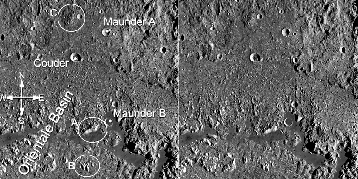
Above: LROC view of the mountains A, B and C as seen by Schröter (see also images in Additional Information section below). - JohnMoore2 JohnMoore2
Images
Johann Schröter carefully studied the changing appearance of the Montes d'Alembert peaks as a function of libration. The results of his analysis can be seen here and here, with additional drawings here, and possibly here (Figure 74?).
Maps
(LAC zone 73) USGS Digital Atlas PDF
Description
Historic name for suspected mountain range near the moon's western limb, in reality the northern part of Orientale Basin seen in profile on the limb.
Description: Elger
(IAU Directions) D'Alembert Mountains. A range on the W. limb running S. from N. lat. 12 deg. ... A very lofty range on the W. limb, extending to S. lat. 11 deg.
Additional Information
- Most of these peaks would probably today be regarded as part of the Montes Cordillera ring of the Orientale basin.
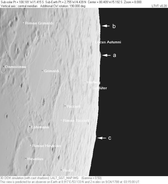
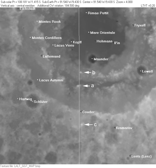
- The peaks seen by Schröter can be readily identified if the date and time of his drawings of them are known. For example, the article by Baum and Whitaker (2007) mentions that his Plate XXX represents the Moon as seen on "1788 September 24 at 4.15 a.m." (presumably around 03:15 UT). Based on this information, a simulation of the expected appearance of the limb can be created using the Kaguya global DEM with LTVT (image on left). The peaks labeled by Schröter can then be identified in an aerial view based on the longitude and latitude of the points used to draw the corresponding features in the simulation (image on right).
| Earth-based view |
Aerial view |
(click on the thumbnails to see full-sized screenshots)
Nomenclature
- Named for Jean le Rond d'Alembert (November 16, 1717 - October 29, 1783), a French mathematician, mechanician, physicist and philosopher. He was also co-editor with Denis Diderot of the Encyclopédie. D'Alembert's method for the wave equation is named after him. The crater D'Alembert is also named in his honor.
- The name Montes d'Alembert was assigned by Schröter to peaks he observed in the limb regions beyond Grimaldi and Schlüter.
- Mary Blagg found this name in use by all three of her authorities and included D'Alembert Mountains as Cat. No. 2020 in her Collated List. The name was adopted in this form in the original IAU nomenclature of Blagg and Müller (1935). Although Schröter had several separately named peaks, the IAU does not appear to have adopted Greek letters for them.
- The name was Latinized to Montes D'Alembert by the LPL, whose work was approved in IAU Transactions XIIB (1964).
- Montes D'Alembert was dropped by the IAU in Menzel, 1971, which found that "certain previously named features, especially those on or near Mare Orientale, proved to be non-existent". The name was reassigned to the unrelated crater now known as D'Alembert.
- Montes d'Alembert is still printed on some of the modern moonmaps, such as the Hallwag map.
LPOD Articles
Bibliography
Baum, R. and Whitaker, E. A. 2007. Mare Orientale: The Eastern Sea in the west - Discovery and nomenclature. Journal of the British Astronomical Association, vol.117, no.3, p.129-135
  Whitaker, E. A. : Mapping and Naming the Moon (Cambridge, 1999).

