Difference between revisions of "Magelhaens"
(Created page with "<div id="content_view" class="wiki" style="display: block"> =Magelhaens= {| class="wiki_table" | Lat: 11.9°S, Long: 44.1°E, Diam: 40 km, Depth: 1.7 km, Rükl: 48<br /> |...") |
|||
| Line 10: | Line 10: | ||
[http://www.lpod.org/coppermine/thumbnails.php?album=search&type=full&search=Magelhaens LPOD Photo Gallery] [http://www.lpi.usra.edu/resources/lunar_orbiter/bin/srch_nam.shtml?Magelhaens%7C0 Lunar Orbiter Images] [http://www.lpi.usra.edu/resources/apollo/search/feature/?feature=Magelhaens Apollo Images]<br /> <br /> - Apollo 8's oblique southward looking ''Hasselblad'' frame [http://history.nasa.gov/ap08fj/photos/13-e/med/as08-13-2225.jpg AS8-13-2225], which is one of the most well-known and most frequently reproduced orbital Apollo photographs of the moon's cratered surface, shows both '''Magelhaens''' and '''Goclenius'''.<br /> This extraordinary photograph was included on pages 620-621 of the article ''A MOST FANTASTIC VOYAGE'' by Lt. Gen. Sam C. Phillips (The Story of Apollo 8's Rendez-Vous with the Moon, ''NATIONAL GEOGRAPHIC'', May 1969).<br /> Research: Danny Caes<br /> <br /> | [http://www.lpod.org/coppermine/thumbnails.php?album=search&type=full&search=Magelhaens LPOD Photo Gallery] [http://www.lpi.usra.edu/resources/lunar_orbiter/bin/srch_nam.shtml?Magelhaens%7C0 Lunar Orbiter Images] [http://www.lpi.usra.edu/resources/apollo/search/feature/?feature=Magelhaens Apollo Images]<br /> <br /> - Apollo 8's oblique southward looking ''Hasselblad'' frame [http://history.nasa.gov/ap08fj/photos/13-e/med/as08-13-2225.jpg AS8-13-2225], which is one of the most well-known and most frequently reproduced orbital Apollo photographs of the moon's cratered surface, shows both '''Magelhaens''' and '''Goclenius'''.<br /> This extraordinary photograph was included on pages 620-621 of the article ''A MOST FANTASTIC VOYAGE'' by Lt. Gen. Sam C. Phillips (The Story of Apollo 8's Rendez-Vous with the Moon, ''NATIONAL GEOGRAPHIC'', May 1969).<br /> Research: Danny Caes<br /> <br /> | ||
==Maps== | ==Maps== | ||
| − | ''([ | + | ''([[LAC%20zone|LAC zone]] 79C1)'' [http://www.lpi.usra.edu/resources/mapcatalog/LAC/lac79/ LAC map] [http://www.lpi.usra.edu/resources/mapcatalog/usgs/I714/ Geologic map]<br /> <br /> |
==Description== | ==Description== | ||
<br /> | <br /> | ||
==Description: Elger== | ==Description: Elger== | ||
| − | ''([ | + | ''([[IAU%20Directions|IAU Directions]])'' MAGELHAENS.--The more northerly and the larger of a pair of ring-plains between [[Colombo|Colombo]] and [[Goclenius|Goclenius]], with a bright and somewhat irregular though continuous border. The dark interior includes a small central mountain. Its companion on the S.E., Magelhaens <u>a</u>, slightly overlaps it. This also has a central hill, and a crater on the outer slope of its W. wall.<br /> <br /> |
==Description: Wikipedia== | ==Description: Wikipedia== | ||
[http://en.wikipedia.org/wiki/Magelhaens_(crater) Magelhaens]<br /> <br /> | [http://en.wikipedia.org/wiki/Magelhaens_(crater) Magelhaens]<br /> <br /> | ||
==Additional Information== | ==Additional Information== | ||
| − | Depth data from [ | + | Depth data from [[Kurt%20Fisher%20crater%20depths|Kurt Fisher database]]<br /> |
* Westfall, 2000: 1.7 km | * Westfall, 2000: 1.7 km | ||
* Viscardy, 1985: 1.96 km | * Viscardy, 1985: 1.96 km | ||
| Line 26: | Line 26: | ||
Fernao De (Ferdinand Magellan); Portuguese explorer (1480-1521).<br /> | Fernao De (Ferdinand Magellan); Portuguese explorer (1480-1521).<br /> | ||
| − | * This name was introduced by [ | + | * This name was introduced by [[M%C3%A4dler|Mädler]] (''[[Whitaker|Whitaker]]'', p. 219). |
* '''Magelhaens Alpha''' (hill southwest of '''Magelhaens'''). | * '''Magelhaens Alpha''' (hill southwest of '''Magelhaens'''). | ||
* '''Magelhaens Beta''' (hill east of '''Magelhaens'''). For '''Magelhaens Alpha''' and '''Beta''', see page 83 of Tony Dethier's ''Maanmonografieen''. | * '''Magelhaens Beta''' (hill east of '''Magelhaens'''). For '''Magelhaens Alpha''' and '''Beta''', see page 83 of Tony Dethier's ''Maanmonografieen''. | ||
Revision as of 16:02, 15 April 2018
Contents
Magelhaens
| Lat: 11.9°S, Long: 44.1°E, Diam: 40 km, Depth: 1.7 km, Rükl: 48 |
Table of Contents

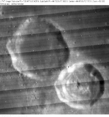
LO-IV-065H_LTVT Magelhaens is in the upper left. The 32-km diam crater in the lower right is Magelhaens A.
Images
LPOD Photo Gallery Lunar Orbiter Images Apollo Images
- Apollo 8's oblique southward looking Hasselblad frame AS8-13-2225, which is one of the most well-known and most frequently reproduced orbital Apollo photographs of the moon's cratered surface, shows both Magelhaens and Goclenius.
This extraordinary photograph was included on pages 620-621 of the article A MOST FANTASTIC VOYAGE by Lt. Gen. Sam C. Phillips (The Story of Apollo 8's Rendez-Vous with the Moon, NATIONAL GEOGRAPHIC, May 1969).
Research: Danny Caes
Maps
(LAC zone 79C1) LAC map Geologic map
Description
Description: Elger
(IAU Directions) MAGELHAENS.--The more northerly and the larger of a pair of ring-plains between Colombo and Goclenius, with a bright and somewhat irregular though continuous border. The dark interior includes a small central mountain. Its companion on the S.E., Magelhaens a, slightly overlaps it. This also has a central hill, and a crater on the outer slope of its W. wall.
Description: Wikipedia
Additional Information
Depth data from Kurt Fisher database
- Westfall, 2000: 1.7 km
- Viscardy, 1985: 1.96 km
- Cherrington, 1969: 1.95 km
Nomenclature
Fernao De (Ferdinand Magellan); Portuguese explorer (1480-1521).
- This name was introduced by Mädler (Whitaker, p. 219).
- Magelhaens Alpha (hill southwest of Magelhaens).
- Magelhaens Beta (hill east of Magelhaens). For Magelhaens Alpha and Beta, see page 83 of Tony Dethier's Maanmonografieen.
LPOD Articles
Bibliography
This page has been edited 1 times. The last modification was made by - tychocrater tychocrater on Jun 13, 2009 3:24 pm - afx3u2