Difference between revisions of "Lamarck"
(Created page with "<div id="content_view" class="wiki" style="display: block"> =Lamarck= {| class="wiki_table" | Lat: 22.9°S, Long: 69.8°W, Diam: 100 km, Depth: 1.11 km, Rükl: 50<br /> |}...") |
|||
| Line 6: | Line 6: | ||
<div id="toc"> | <div id="toc"> | ||
=Table of Contents= | =Table of Contents= | ||
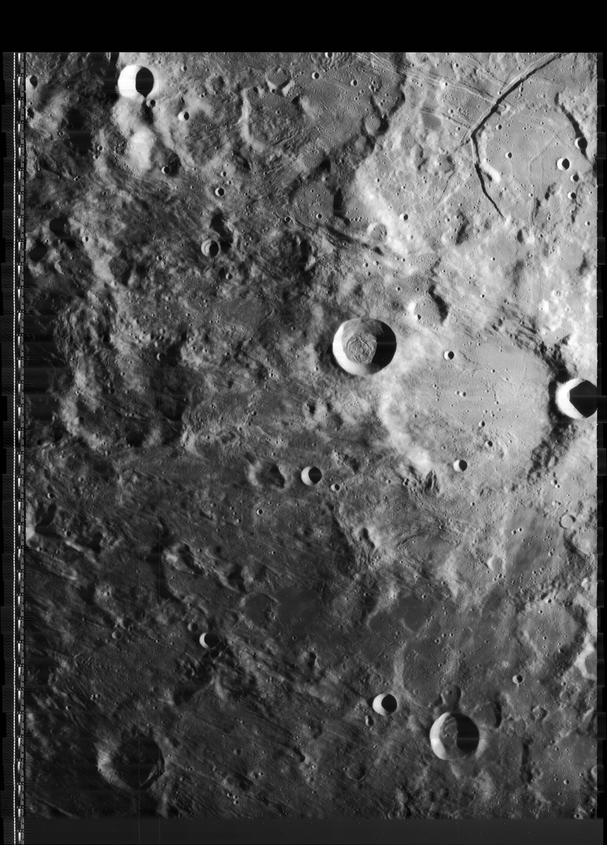
| − | <div style="margin-left: 1em">[#Lamarck Lamarck]</div><div style="margin-left: 2em">[#Lamarck-Images Images]</div><div style="margin-left: 2em">[#Lamarck-Maps Maps]</div><div style="margin-left: 2em">[#Lamarck-Description Description]</div><div style="margin-left: 2em">[#Lamarck-Description: Wikipedia Description: Wikipedia]</div><div style="margin-left: 2em">[#Lamarck-Additional Information Additional Information]</div><div style="margin-left: 2em">[#Lamarck-Nomenclature Nomenclature]</div><div style="margin-left: 2em">[#Lamarck-LPOD Articles LPOD Articles]</div><div style="margin-left: 2em">[#Lamarck-Bibliography Bibliography]</div></div>[http://www.lpod.org/coppermine/albums/userpics/Lamarck_LO-IV-168H_LTVT.JPG [[Image:normal_Lamarck_LO-IV-168H_LTVT.JPG|external image normal_Lamarck_LO-IV-168H_LTVT.JPG]]]<br /> ''[http://lpod.org/coppermine/displayimage.php?pos=-1938 LO-IV-168H]'' '''Lamarck''' is at the center, blending into [ | + | <div style="margin-left: 1em">[#Lamarck Lamarck]</div><div style="margin-left: 2em">[#Lamarck-Images Images]</div><div style="margin-left: 2em">[#Lamarck-Maps Maps]</div><div style="margin-left: 2em">[#Lamarck-Description Description]</div><div style="margin-left: 2em">[#Lamarck-Description: Wikipedia Description: Wikipedia]</div><div style="margin-left: 2em">[#Lamarck-Additional Information Additional Information]</div><div style="margin-left: 2em">[#Lamarck-Nomenclature Nomenclature]</div><div style="margin-left: 2em">[#Lamarck-LPOD Articles LPOD Articles]</div><div style="margin-left: 2em">[#Lamarck-Bibliography Bibliography]</div></div>[http://www.lpod.org/coppermine/albums/userpics/Lamarck_LO-IV-168H_LTVT.JPG [[Image:normal_Lamarck_LO-IV-168H_LTVT.JPG|external image normal_Lamarck_LO-IV-168H_LTVT.JPG]]]<br /> ''[http://lpod.org/coppermine/displayimage.php?pos=-1938 LO-IV-168H]'' '''Lamarck''' is at the center, blending into [[Darwin|Darwin]] above it. The crater in the lower right is '''[[Byrgius|Byrgius]] D'''.<br /> <br /> |
==Images== | ==Images== | ||
[http://www.lpod.org/coppermine/thumbnails.php?album=search&type=full&search=Lamarck LPOD Photo Gallery] [http://www.lpi.usra.edu/resources/lunar_orbiter/bin/srch_nam.shtml?Lamarck%7C0 Lunar Orbiter Images]<br /> Is the most pronounced crater in '''Lamarck''', known as '''Lamarck B''', a Concentric Crater? Take a look at the Hi-Res scan of Lunar Orbiter 4's photograph [http://www.lpi.usra.edu/resources/lunarorbiter/images/preview/4168_h1.jpg LOIV-168-h1].<br /> Research: Danny Caes<br /> <br /> | [http://www.lpod.org/coppermine/thumbnails.php?album=search&type=full&search=Lamarck LPOD Photo Gallery] [http://www.lpi.usra.edu/resources/lunar_orbiter/bin/srch_nam.shtml?Lamarck%7C0 Lunar Orbiter Images]<br /> Is the most pronounced crater in '''Lamarck''', known as '''Lamarck B''', a Concentric Crater? Take a look at the Hi-Res scan of Lunar Orbiter 4's photograph [http://www.lpi.usra.edu/resources/lunarorbiter/images/preview/4168_h1.jpg LOIV-168-h1].<br /> Research: Danny Caes<br /> <br /> | ||
==Maps== | ==Maps== | ||
| − | ''([ | + | ''([[LAC%20zone|LAC zone]] 92A4)'' [http://planetarynames.wr.usgs.gov/images/Lunar/lac_92.pdf USGS Digital Atlas PDF] [http://www.lpi.usra.edu/resources/mapcatalog/LAC/lac92/ LAC map] [http://www.lpi.usra.edu/resources/mapcatalog/usgs/I755/ Geologic map]<br /> <br /> |
==Description== | ==Description== | ||
<br /> | <br /> | ||
| Line 16: | Line 16: | ||
[http://en.wikipedia.org/wiki/Lamarck_(crater) Lamarck]<br /> <br /> | [http://en.wikipedia.org/wiki/Lamarck_(crater) Lamarck]<br /> <br /> | ||
==Additional Information== | ==Additional Information== | ||
| − | Depth data from [ | + | Depth data from [[Kurt%20Fisher%20crater%20depths|Kurt Fisher database]]<br /> |
* Westfall, 2000: 1.11 km | * Westfall, 2000: 1.11 km | ||
* Cherrington, 1969: 2.8 km | * Cherrington, 1969: 2.8 km | ||
| Line 23: | Line 23: | ||
* Named for [http://en.wikipedia.org/wiki/Jean-Baptiste_Lamarck Jean-Baptiste Pierre Antoine de Monet], Chevalier de Lamarck (August 1, 1744 – December 28, 1829), a French soldier, naturalist, academic and an early proponent of the idea that evolution occurred and proceeded in accordance with natural laws. Lamarck is usually remembered for his belief in the inheritance of acquired characteristics, and the "use and disuse" model by which organisms developed their characteristics. | * Named for [http://en.wikipedia.org/wiki/Jean-Baptiste_Lamarck Jean-Baptiste Pierre Antoine de Monet], Chevalier de Lamarck (August 1, 1744 – December 28, 1829), a French soldier, naturalist, academic and an early proponent of the idea that evolution occurred and proceeded in accordance with natural laws. Lamarck is usually remembered for his belief in the inheritance of acquired characteristics, and the "use and disuse" model by which organisms developed their characteristics. | ||
| − | * This name was assigned in the ''[ | + | * This name was assigned in the ''[[Rectified%20Lunar%20Atlas|Rectified Lunar Atlas]]'' (1963), based on Earth-based photos of the [[librations|libration]] zones, and approved by the [[IAU|IAU]] in [[IAU%20Transactions%20XIIB|1964]], to which it was described as a 96 km diameter crater centered at 22.5°S, 70.0°E, and formerly regarded as the southern part of [[Darwin|Darwin]]. |
| − | * In preparing its initial long list of farside names, the IAU Working Group for Lunar Nomenclature was initially unable to find evidence in space-based overhead views of a significant crater at that location, and announced at the [ | + | * In preparing its initial long list of farside names, the IAU Working Group for Lunar Nomenclature was initially unable to find evidence in space-based overhead views of a significant crater at that location, and announced at the [[IAU%20Transactions%20XIVB|August 1970]] IAU meeting its plan of deleting the 1964 approval and reassigning the name to a farside crater now known as [[Hopmann|Hopmann]]. |
| − | * Subsequent to the 1970 meeting, Whitaker produced space-based images of the crater he had intended to name. The name was reapproved in [ | + | * Subsequent to the 1970 meeting, Whitaker produced space-based images of the crater he had intended to name. The name was reapproved in [[Menzel%2C%201971#Relocations_2|Menzel, 1971]] as representing the crater at "22°S, 70°W". |
| − | * The version of [ | + | * The version of [[DMA|ACIC]] map [[LMP|LMP-3]] from October, 1970 (prepared before the final IAU farside list had been published) labels '''Lamarck''' at the proposed changed location (the current [[Hopmann|Hopmann]]). |
<br /> <br /> | <br /> <br /> | ||
==LPOD Articles== | ==LPOD Articles== | ||
Revision as of 16:00, 15 April 2018
Contents
Lamarck
| Lat: 22.9°S, Long: 69.8°W, Diam: 100 km, Depth: 1.11 km, Rükl: 50 |
Table of Contents
[#Lamarck Lamarck]
[#Lamarck-Images Images]
[#Lamarck-Maps Maps]
[#Lamarck-Description Description]
[#Lamarck-Description: Wikipedia Description: Wikipedia]
[#Lamarck-Additional Information Additional Information]
[#Lamarck-Nomenclature Nomenclature]
[#Lamarck-LPOD Articles LPOD Articles]
[#Lamarck-Bibliography Bibliography]

LO-IV-168H Lamarck is at the center, blending into Darwin above it. The crater in the lower right is Byrgius D.
Images
LPOD Photo Gallery Lunar Orbiter Images
Is the most pronounced crater in Lamarck, known as Lamarck B, a Concentric Crater? Take a look at the Hi-Res scan of Lunar Orbiter 4's photograph LOIV-168-h1.
Research: Danny Caes
Maps
(LAC zone 92A4) USGS Digital Atlas PDF LAC map Geologic map
Description
Description: Wikipedia
Additional Information
Depth data from Kurt Fisher database
- Westfall, 2000: 1.11 km
- Cherrington, 1969: 2.8 km
Possible Concentric Crater: Lamarck B.- DannyCaes DannyCaes Nov 2, 2009
Nomenclature
- Named for Jean-Baptiste Pierre Antoine de Monet, Chevalier de Lamarck (August 1, 1744 – December 28, 1829), a French soldier, naturalist, academic and an early proponent of the idea that evolution occurred and proceeded in accordance with natural laws. Lamarck is usually remembered for his belief in the inheritance of acquired characteristics, and the "use and disuse" model by which organisms developed their characteristics.
- This name was assigned in the Rectified Lunar Atlas (1963), based on Earth-based photos of the libration zones, and approved by the IAU in 1964, to which it was described as a 96 km diameter crater centered at 22.5°S, 70.0°E, and formerly regarded as the southern part of Darwin.
- In preparing its initial long list of farside names, the IAU Working Group for Lunar Nomenclature was initially unable to find evidence in space-based overhead views of a significant crater at that location, and announced at the August 1970 IAU meeting its plan of deleting the 1964 approval and reassigning the name to a farside crater now known as Hopmann.
- Subsequent to the 1970 meeting, Whitaker produced space-based images of the crater he had intended to name. The name was reapproved in Menzel, 1971 as representing the crater at "22°S, 70°W".
- The version of ACIC map LMP-3 from October, 1970 (prepared before the final IAU farside list had been published) labels Lamarck at the proposed changed location (the current Hopmann).
LPOD Articles
Bibliography
This page has been edited 1 times. The last modification was made by - tychocrater tychocrater on Jun 13, 2009 3:24 pm - afx3u2