Difference between revisions of "Firmicus"
| Line 3: | Line 3: | ||
{| class="wiki_table" | {| class="wiki_table" | ||
| | | | ||
| − | Lat: 7.3°N, Long: 63.4°E, Diam: 56 km, Depth: 2.14 km, [ | + | Lat: 7.3°N, Long: 63.4°E, Diam: 56 km, Depth: 2.14 km, [[R%C3%BCkl%2038|Rükl: 38]]<br /> |
|} | |} | ||
<div id="toc"> | <div id="toc"> | ||
| Line 15: | Line 15: | ||
<br /> | <br /> | ||
==Maps== | ==Maps== | ||
| − | ''([ | + | ''([[LAC%20zone|LAC zone]] 62C1)'' [http://www.lpi.usra.edu/resources/mapcatalog/LAC/lac62/ LAC map] [http://www.lpi.usra.edu/resources/mapcatalog/usgs/I837/ Geologic map] [http://www.lpi.usra.edu/resources/mapcatalog/LM/lm62/ LM map] [http://www.lpi.usra.edu/resources/mapcatalog/LTO/lto62c1_1/ LTO map]<br /> <br /> |
==Description== | ==Description== | ||
<br /> | <br /> | ||
==Description: Elger== | ==Description: Elger== | ||
| − | ''([ | + | ''([[IAU%20Directions|IAU Directions]])'' FIRMICUS.--A somewhat larger, more regular, but, in other respects, very similar ring-plain, N.E. of [[Apollonius|Apollonius]]. Some distance on the E., Madler noted a number of dark-grey streaks which apparently undergo periodical changes, suggestive of something akin to vegetation. They are situated near a prominent mountain situated in a level region.<br /> <br /> |
==Description: Wikipedia== | ==Description: Wikipedia== | ||
[http://en.wikipedia.org/wiki/Firmicus_(crater) Firmicus]<br /> <br /> | [http://en.wikipedia.org/wiki/Firmicus_(crater) Firmicus]<br /> <br /> | ||
==Additional Information== | ==Additional Information== | ||
| − | Depth data from [ | + | Depth data from [[Kurt%20Fisher%20crater%20depths|Kurt Fisher database]]<br /> |
* Pike, 1976: 2.14 km | * Pike, 1976: 2.14 km | ||
Revision as of 15:48, 15 April 2018
Contents
Firmicus
|
Lat: 7.3°N, Long: 63.4°E, Diam: 56 km, Depth: 2.14 km, Rükl: 38 |
Table of Contents
 LO-IV-184H
Images
LPOD Photo Gallery Lunar Orbiter Images Apollo Images
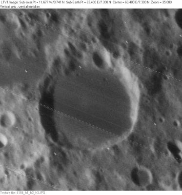
- AS11-42-6214 and AS11-42-6222 (made during the mission of Apollo 11 in july 1969) show orbital northwest-looking views of both Firmicus (foreground) and Mare Crisium in the distance. Note the dark streak of Lacus Perseverantiae nearby Firmicus.
- Apollonius N, the 9th item in C.A.Wood's list of Concentric Craters (1978), is noticeable on the Hi-Res scan of Lunar Orbiter 4's photograph LOIV-184-h1. Because of the oblique look at it (at the region of Apollonius and Apollonius N) it's rather difficult to locate both of them. But... once you have detected the dark-floored FIRMICUS, it will be an easy task to discover Apollonius N. In this online scan of LOIV-184-h1, we are looking "upside down" at the Apollonius region (north toward the bottom). The Concentric Crater Apollonius N is "just above" the dark-floored Firmicus (in reality it's SOUTH of Firmicus).
- Research Lunar Orbiter IV and orbital Apollo 11 photography: Danny Caes
Maps
(LAC zone 62C1) LAC map Geologic map LM map LTO map
Description
Description: Elger
(IAU Directions) FIRMICUS.--A somewhat larger, more regular, but, in other respects, very similar ring-plain, N.E. of Apollonius. Some distance on the E., Madler noted a number of dark-grey streaks which apparently undergo periodical changes, suggestive of something akin to vegetation. They are situated near a prominent mountain situated in a level region.
Description: Wikipedia
Additional Information
Depth data from Kurt Fisher database
- Pike, 1976: 2.14 km
- Westfall, 2000: 2.14 km
- Viscardy, 1985: 1.7 km
- Cherrington, 1969: 2.56 km
Nomenclature
Julius Firmicus Maternus, (fl. A.D. 330-354) a writer and notable astrologer, who lived in the reign of Constantine I and his successors. Author of Matheseos Libri Octo ("Eight Books of Astrology", c. 330).
North Valley
- Southeast of Mare Crisium (near Condorcet, Auzout, Firmicus, and Apollonius) runs the unofficially named North Valley/ Vallis North; or Vermiform Valley. These unofficial names are included in the Hitchhiker's Guide to Rukl 38.
LPOD Articles
Bibliography
This page has been edited 1 times. The last modification was made by - tychocrater tychocrater on Jun 13, 2009 3:24 pm - afx3u2