Maskelyne
Contents
Maskelyne
| Lat: 2.2°N, Long: 30.1°E, Diam: 23 km, Depth: 2.5 km, Rükl: 36 |
Table of Contents
[#Maskelyne Maskelyne]
[#Maskelyne-Images Images]
[#Maskelyne-Maps Maps]
[#Maskelyne-Description Description]
[#Maskelyne-Description: Elger Description: Elger]
[#Maskelyne-Description: Wikipedia Description: Wikipedia]
[#Maskelyne-Additional Information Additional Information]
[#Maskelyne-Nomenclature Nomenclature]
[#Maskelyne-LPOD Articles LPOD Articles]
[#Maskelyne-Bibliography Bibliography]
[#Maskelyne-Nevil Maskelyne in the Sourcebook Project (William R. Corliss) Nevil Maskelyne in the Sourcebook Project (William R. Corliss)]

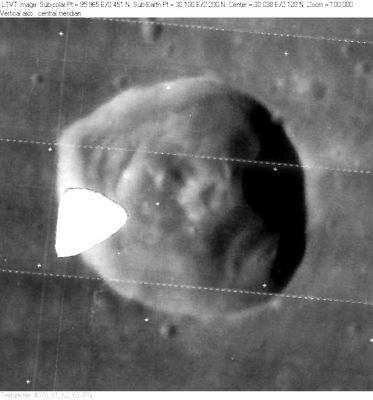
LO-IV-078H The white triangle is a defect in the Lunar Orbiter film.
Images
LPOD Photo Gallery Lunar Orbiter Images Apollo Images (see also: Maskelyne, west of)
- Maskelyne F, an incomplete ring in Mare Tranquillitatis at 4.0°N/ 35.5°E, was captured on Frame 2005, made by Lunar Orbiter 2. Note the half-submerged craterlets at the base of Maskelyne F's curved hillock. Maskelyne F was also captured on Frame 5052, made by Lunar Orbiter 5. Note the bright retro-reflection ("heiligenschein").
- See also Apollo 10's oblique view of Maskelyne F: AS10-30-4438, and close up: AS10-31-4580.
- AS11-37-5437 is one of the most frequently reproduced orbital Hasselblad-photographs, made during the mission of Apollo 11. It shows Maskelyne in the lower-right corner, and Statio Tranquillitatis ('Tranquillity base: the landing site of Apollo 11's LM Eagle) a little above and to the right of centre (near the morning terminator). The dark out-of-focus object in the lower left corner is one of LM Eagles sixteen small exhaust-nozzles.
- An impressive Hi-Res version of Apollo 10's AS10-29-4296 shows Maskelyne' near the photograph's left margin, and one of LM Snoopys nozzle clusters in the lower right corner.
- Additional research Lunar Orbiter and Apollo photography: Danny Caes
Maps
(LAC zone 61D4) LAC map Geologic map AIC map LTO map
USGS Map of Apollo Landing Site 1 (I-617) (slightly east of craterlet Maskelyne DA)
Description
Description: Elger
(IAU Directions) MASKELYNE.--A regular ring-plain, 19 miles in diameter, standing almost isolated in the Mare Tranquillitatis. The floor, which includes a central mountain, is depressed some 3,000 feet below the surrounding surface. There are prominent terraces on the inner slope of the walls. Schmidt shows no craters upon them, but Madler draws a small one on the W., the existence of which I can confirm.
Description: Wikipedia
Additional Information
- Depth data from Kurt Fisher database
- Pike, 1976: 2.5 km
- Westfall, 2000: 2.5 km
- Viscardy, 1985: 2.5 km
- A thermal anomaly crater, implying a youthful age - Moore et al, 1980
Nomenclature
- Named for Nevil Maskelyne (1732-1811), a British astronomer.
- This name was one of eight names introduced by Lohrmann (Whitaker, p. 119). All of Lohrmann's names were adopted by the three "authorities" cited in Mary Blagg's Collated List, and incorporated into the original IAU nomenclature of Blagg and Müller (1935).
- There's a lot of NASA- and Apollo-related unofficial nomenclature and nicknames near Maskelyne and Montes Secchi. An overview of all the nicknamed lunar formations is seen in the LPOD US-1 and Other Signposts.
- A ridge between Maskelyne and Maskelyne B (say: near Maskelyne B) seems to have been nicknamed Snake Ridge (this before and during the first manned landing on the moon). See LPOD Monday Morning Quarterbacking, 4 decades later.
- Maskelyne A was Van Langren's Wendelini (Vendelinus). See page 197 in E.A.Whitaker's Mapping and Naming the Moon.
LPOD Articles
Bibliography
- Maskelyne and the nearby landing target of Apollo 11: APOLLO OVER THE MOON; A VIEW FROM ORBIT, Chapter 2: Regional views, Figure 23.
Nevil Maskelyne in the Sourcebook Project (William R. Corliss)
- In Mysterious Universe, a handbook of astronomical anomalies (1979) :
- Pages 223-224: Lights on the Moon (Stanley C. Ogilvy, Popular Astronomy, 1949)
This page has been edited 1 times. The last modification was made by - tychocrater tychocrater on Jun 13, 2009 3:24 pm - afx4