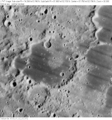
Ulugh Beigh
Contents
Ulugh Beigh
|
Lat: 32.7°N, Long: 81.9°W, Diam: 54 km, Depth: 0.58 km, Rükl: 8 |
LO-IV-189H Ulugh Beigh is the dark-floored area in the center. In the upper right corner one can see a southern extension out of the similarly dark-floored 41-km Ulugh Beigh A. The 21-km depression just outside the southwest rim of Ulugh Beigh is Ulugh Beigh D.
Images
LPOD Photo Gallery Lunar Orbiter Images Apollo Images
Maps
(LAC zone 22D4) USGS Digital Atlas PDF
Description
Description: Elger
(IAU Directions) ULUGH BEIGH.--A good-sized ring-plain, W. of Lichtenberg, with a bright border and central mountain. Too near the limb for observation.
Description: Wikipedia
Additional Information
Depth data from Kurt Fisher database
- Westfall, 2000: 0.58 km
- Cherrington, 1969: 1.7 km
Ulugh Beigh A has a neat zig-zaggy sinuous rille on the ESE part of its floor, see: http://bit.ly/2CqdfFC
Nomenclature
Ulugh-Beg; Mongolian astronomer, mathematician (1394-1449).
- According to Whitaker (p. 219), this name was introduced by Mädler. Also according to Whitaker (p. 235), due to ambiguities in the map of Blagg and Müller, the boundaries of the feature were re-drawn in the 1960's. - Jim Mosher
- Printed as Ulugh Biegh on the revised and reprinted edition of the National Geographic Society's map THE EARTH'S MOON. - DannyCaes Oct 8, 2015 (selenography's nitpicker).
LPOD Articles
Bibliography
