Difference between revisions of "Dorsum Buckland"
| Line 11: | Line 11: | ||
|} | |} | ||
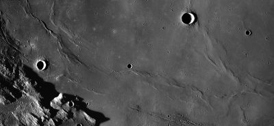
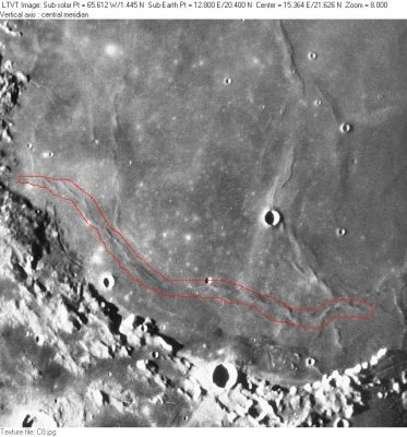
'''Left:''' ''[http://lroc.sese.asu.edu/index.html LROC]'' WAC mosaic (No.'s [http://wms.lroc.asu.edu/lroc/view_lroc/LRO-L-LROC-2-EDR-V1.0/M117420091ME M117420091ME], [http://wms.lroc.asu.edu/lroc/view_lroc/LRO-L-LROC-2-EDR-V1.0/M117352260ME M117352260ME], [http://wms.lroc.asu.edu/lroc/view_lroc/LRO-L-LROC-2-EDR-V1.0/M117413324ME M117413324ME], [http://wms.lroc.asu.edu/lroc/view_lroc/LRO-L-LROC-2-EDR-V1.0/M117379381ME M117379381ME], [http://wms.lroc.asu.edu/lroc/view_lroc/LRO-L-LROC-2-EDR-V1.0/M117372616ME M117372616ME], [http://wms.lroc.asu.edu/lroc/view_lroc/LRO-L-LROC-2-EDR-V1.0/M117392969ME M117392969ME]). Processed by [http://ltvt.wikispaces.com/Utility%20Programs#WAC_Viewer LROC_WAC_Previewer].<br /> '''Right:''' ''[http://lpod.org/coppermine/displayimage.php?pos=-2774 Consolidated Lunar Atlas; Plate C8]'' The [[IAU|IAU]]'s '''"Dorsum" Buckland''' consists of a long series of ridges, outlined in red, along the southwestern shore of [[Mare%20Serenitatis|Mare Serenitatis]]. The hills running roughly parallel to it on the south are part of [[Montes%20Haemus|Montes Haemus]]. The largest of the several craters in the mare is 15-km [[Bessel|Bessel]], while the prominent 26-km crater just to the right of bottom center is [[Menelaus|Menelaus]]. At least part of the ridge running north from the eastern end of '''Buckland''' (through [[Bessel|Bessel]]) seems to be thought of as a part of the [[Dorsa%20Lister|Dorsa Lister]] system. On the west, the fainter ridge running north from '''Buckland''' (from a point slightly to the right of the position of the prominent 12-km mare crater [[Sulpicius%20Gallus|Sulpicius Gallus]]), is sometimes identified as part of [[Dorsum%20Von%20Cotta|Dorsum Von Cotta]]. Several other named [[dorsum|dorsa]] are also visible in this view.<br /> <div id="toc"> | '''Left:''' ''[http://lroc.sese.asu.edu/index.html LROC]'' WAC mosaic (No.'s [http://wms.lroc.asu.edu/lroc/view_lroc/LRO-L-LROC-2-EDR-V1.0/M117420091ME M117420091ME], [http://wms.lroc.asu.edu/lroc/view_lroc/LRO-L-LROC-2-EDR-V1.0/M117352260ME M117352260ME], [http://wms.lroc.asu.edu/lroc/view_lroc/LRO-L-LROC-2-EDR-V1.0/M117413324ME M117413324ME], [http://wms.lroc.asu.edu/lroc/view_lroc/LRO-L-LROC-2-EDR-V1.0/M117379381ME M117379381ME], [http://wms.lroc.asu.edu/lroc/view_lroc/LRO-L-LROC-2-EDR-V1.0/M117372616ME M117372616ME], [http://wms.lroc.asu.edu/lroc/view_lroc/LRO-L-LROC-2-EDR-V1.0/M117392969ME M117392969ME]). Processed by [http://ltvt.wikispaces.com/Utility%20Programs#WAC_Viewer LROC_WAC_Previewer].<br /> '''Right:''' ''[http://lpod.org/coppermine/displayimage.php?pos=-2774 Consolidated Lunar Atlas; Plate C8]'' The [[IAU|IAU]]'s '''"Dorsum" Buckland''' consists of a long series of ridges, outlined in red, along the southwestern shore of [[Mare%20Serenitatis|Mare Serenitatis]]. The hills running roughly parallel to it on the south are part of [[Montes%20Haemus|Montes Haemus]]. The largest of the several craters in the mare is 15-km [[Bessel|Bessel]], while the prominent 26-km crater just to the right of bottom center is [[Menelaus|Menelaus]]. At least part of the ridge running north from the eastern end of '''Buckland''' (through [[Bessel|Bessel]]) seems to be thought of as a part of the [[Dorsa%20Lister|Dorsa Lister]] system. On the west, the fainter ridge running north from '''Buckland''' (from a point slightly to the right of the position of the prominent 12-km mare crater [[Sulpicius%20Gallus|Sulpicius Gallus]]), is sometimes identified as part of [[Dorsum%20Von%20Cotta|Dorsum Von Cotta]]. Several other named [[dorsum|dorsa]] are also visible in this view.<br /> <div id="toc"> | ||
| − | + | <br /> | |
| − | |||
==Images== | ==Images== | ||
[http://www.lpod.org/coppermine/thumbnails.php?album=search&type=full&search=Dorsum%20Buckland LPOD Photo Gallery] [http://www.lpi.usra.edu/resources/lunar_orbiter/bin/srch_nam.shtml?Dorsum%20Buckland%7C0 Lunar Orbiter Images] [http://www.lpi.usra.edu/resources/apollo/search/feature/?feature=Dorsum%20Buckland Apollo Images]<br /> | [http://www.lpod.org/coppermine/thumbnails.php?album=search&type=full&search=Dorsum%20Buckland LPOD Photo Gallery] [http://www.lpi.usra.edu/resources/lunar_orbiter/bin/srch_nam.shtml?Dorsum%20Buckland%7C0 Lunar Orbiter Images] [http://www.lpi.usra.edu/resources/apollo/search/feature/?feature=Dorsum%20Buckland Apollo Images]<br /> | ||
| Line 44: | Line 43: | ||
[[Alphabetical%20Index|Named Features]] -- Prev: [[Dorsum%20Bucher|Dorsum Bucher]] -- Next: [[Buffon|Buffon]]<br /> | [[Alphabetical%20Index|Named Features]] -- Prev: [[Dorsum%20Bucher|Dorsum Bucher]] -- Next: [[Buffon|Buffon]]<br /> | ||
---- | ---- | ||
| − | + | </div> | |
Revision as of 16:20, 15 April 2018
Contents
Dorsum Buckland
|
Lat: 19.51°N, Long: 14.34°E, Length: 369.13 km, Height: km, Rükl: 23 | |
Right: Consolidated Lunar Atlas; Plate C8 The IAU's "Dorsum" Buckland consists of a long series of ridges, outlined in red, along the southwestern shore of Mare Serenitatis. The hills running roughly parallel to it on the south are part of Montes Haemus. The largest of the several craters in the mare is 15-km Bessel, while the prominent 26-km crater just to the right of bottom center is Menelaus. At least part of the ridge running north from the eastern end of Buckland (through Bessel) seems to be thought of as a part of the Dorsa Lister system. On the west, the fainter ridge running north from Buckland (from a point slightly to the right of the position of the prominent 12-km mare crater Sulpicius Gallus), is sometimes identified as part of Dorsum Von Cotta. Several other named dorsa are also visible in this view.
Images
LPOD Photo Gallery Lunar Orbiter Images Apollo Images
- Apollo 17's Nikon photograph AS17-159-23928 shows Dorsum Buckland running across the image's upper half, while Rimae Sulpicius Gallus and part of Montes Haemus are noticeable near the image's lower margin. Research: Danny Caes.
- Three of Apollo 15's orbital close-up Hasselblad photographs of this area show a remarkable bright craterlet with unexpected dark "tongue" of ejected material at the southwestern rim of it, located at the western end of Dorsum Buckland (near the southern end of Dorsum Gast). The exact coordinates of that curious craterlet are: 23° North/ 8°40' East.
The three Hasselblad close-ups of that curious craterlet are:
AS15-81-10876
AS15-81-10881
AS15-81-10883
Research: Danny Caes.
AS17-149-22881, made during the mission of Apollo 17, is an orbital color Hasselblad of the same bright craterlet with the dark "tongue".
Research: Danny Caes.
Note that the bright craterlet with dark "tongue" is also mentioned in David Woods's and Frank O' Brien's Apollo 15 Flight Journal, at 196:45:11 Ground Elapsed Time, in the page Orbital Science and Crew Rest.
Maps
(LAC zone 42D1) LAC map Geologic map LM map LTO map
Description
Wikipedia
Additional Information
- IAU page: Dorsum Buckland
Nomenclature
William; British Earth scientist (1784-1856).
- Dorsum Buckland was among the many provisional dorsa names appearing on NASA’s LTO charts that were approved by the IAU “as now assigned and printed” (on those charts) in IAU Transactions XVIB. The name is printed on many LTO charts, hence its unusually great length. Although the name "dorsum" is singular, implying a single ridge, Dorsum Buckland appears to consist of many discontinuous parts.
LROC Articles
LPOD Articles
Bibliography
Named Features -- Prev: Dorsum Bucher -- Next: Buffon

