Difference between revisions of "Kane"
(Created page with "<div id="content_view" class="wiki" style="display: block"> =Kane= {| class="wiki_table" | Lat: 63.1°N, Long: 26.1°E, Diam: 54 km, Depth: 0.57 km, [/R%C3%BCkl%205 Rükl:...") |
|||
| (2 intermediate revisions by the same user not shown) | |||
| Line 3: | Line 3: | ||
{| class="wiki_table" | {| class="wiki_table" | ||
| | | | ||
| − | Lat: 63.1°N, Long: 26.1°E, Diam: 54 km, Depth: 0.57 km, [ | + | Lat: 63.1°N, Long: 26.1°E, Diam: 54 km, Depth: 0.57 km, [[R%C3%BCkl%205|Rükl: 5]], [[Stratigraphy|pre-Nectarian?]]<br /> |
|} | |} | ||
<div id="toc"> | <div id="toc"> | ||
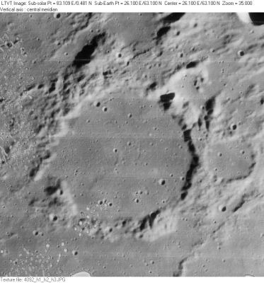
| − | + | [http://www.lpod.org/coppermine/albums/userpics/Kane_LO-IV-092H_LTVT.JPG [[Image:Normal_Kane_LO-IV-092H_LTVT.JPG|external image normal_Kane_LO-IV-092H_LTVT.JPG]]]''[http://lpod.org/coppermine/displayimage.php?pos=-2598 LO-IV-092H]'' '''Kane''' is in the center. The 26-km crater partially visible directly above it at the top margin is '''[[Moigno|Moigno]] B'''. The crater outside the east rim of '''Kane''' is unnamed.<br /> <br /> | |
| − | |||
==Images== | ==Images== | ||
[http://www.lpod.org/coppermine/thumbnails.php?album=search&type=full&search=Kane LPOD Photo Gallery] [http://www.lpi.usra.edu/resources/lunar_orbiter/bin/srch_nam.shtml?Kane%7C0 Lunar Orbiter Images]<br /> <br /> | [http://www.lpod.org/coppermine/thumbnails.php?album=search&type=full&search=Kane LPOD Photo Gallery] [http://www.lpi.usra.edu/resources/lunar_orbiter/bin/srch_nam.shtml?Kane%7C0 Lunar Orbiter Images]<br /> <br /> | ||
==Maps== | ==Maps== | ||
| − | ''([ | + | ''([[LAC%20zone|LAC zone]] 13B1)'' [http://www.lpi.usra.edu/resources/mapcatalog/LAC/lac13/ LAC map] [http://www.lpi.usra.edu/resources/mapcatalog/usgs/I725/ Geologic map]<br /> <br /> |
==Description== | ==Description== | ||
<br /> | <br /> | ||
| Line 17: | Line 16: | ||
[http://en.wikipedia.org/wiki/Kane_(crater) Kane]<br /> <br /> | [http://en.wikipedia.org/wiki/Kane_(crater) Kane]<br /> <br /> | ||
==Additional Information== | ==Additional Information== | ||
| − | Depth data from [ | + | Depth data from [[Kurt%20Fisher%20Crater%20Depths|Kurt Fisher database]]<br /> |
* Pike, 1976: 0.57 km | * Pike, 1976: 0.57 km | ||
* Westfall, 2000: 0.57 km | * Westfall, 2000: 0.57 km | ||
* Cherrington, 1969: 1.31 km | * Cherrington, 1969: 1.31 km | ||
| − | * Satellite crater Kane F is on the [ | + | * Satellite crater Kane F is on the [[ALPO%20list%20of%20bright%20ray%20craters|ALPO list of bright ray craters]]. |
<br /> | <br /> | ||
==Nomenclature== | ==Nomenclature== | ||
* Elisha Kent; American explorer (1820-1857). | * Elisha Kent; American explorer (1820-1857). | ||
| − | * According to [ | + | * According to [[Whitaker|Whitaker]] (p. 224), this name was originally proposed by [[Schmidt|Schmidt]]. |
* The incomplete formation southeast of Kane (between Kane and Gartner) was called '''Danjon''' by Felix Chemla Lamech. The official name Danjon went to a crater on the moon's farside (I.A.U.). | * The incomplete formation southeast of Kane (between Kane and Gartner) was called '''Danjon''' by Felix Chemla Lamech. The official name Danjon went to a crater on the moon's farside (I.A.U.). | ||
<br /> | <br /> | ||
| Line 37: | Line 36: | ||
<br /> | <br /> | ||
---- | ---- | ||
| − | + | </div> | |
Latest revision as of 01:55, 16 April 2018
Contents
Kane
|
Lat: 63.1°N, Long: 26.1°E, Diam: 54 km, Depth: 0.57 km, Rükl: 5, pre-Nectarian? |

Images
LPOD Photo Gallery Lunar Orbiter Images
Maps
(LAC zone 13B1) LAC map Geologic map
Description
Description: Wikipedia
Additional Information
Depth data from Kurt Fisher database
- Pike, 1976: 0.57 km
- Westfall, 2000: 0.57 km
- Cherrington, 1969: 1.31 km
- Satellite crater Kane F is on the ALPO list of bright ray craters.
Nomenclature
- Elisha Kent; American explorer (1820-1857).
- According to Whitaker (p. 224), this name was originally proposed by Schmidt.
- The incomplete formation southeast of Kane (between Kane and Gartner) was called Danjon by Felix Chemla Lamech. The official name Danjon went to a crater on the moon's farside (I.A.U.).
LPOD Articles
Bibliography
- Lamech's "Danjon" between Kane and Gartner: NAMED LUNAR FORMATIONS, by Mary Blagg.