Weinek
Contents
[hide]Weinek
|
Lat: 27.5°S, Long: 37.0°E, Diam: 32 km, Depth: 3.37 km, Rükl: 58 |
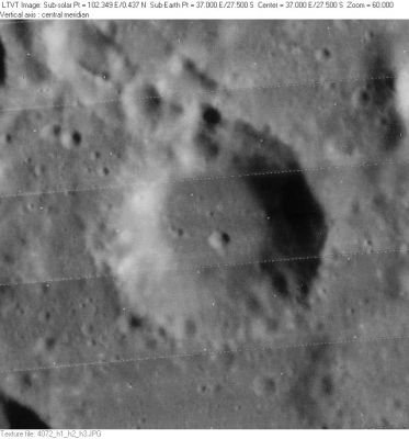
LO-IV-072H A small part of the sunlit west rim of 11-km Weinek B is visible in the upper right; and the shadowed east rim of 20-km Neander C in the lower left.
Images
LPOD Photo Gallery Lunar Orbiter Images
Was southern crater Weinek captured on one or more orbital photographs made during Project Apollo? Perhaps... (or... none?).
Something of Weinek is probably noticeable in the south-looking oblique Mapping/Metric Fairchild camera photographs of Apollo 16 (in the REV 26 frames, especially in frame AS16-M-0685, more precisely at the central part of the curved horizon).
Research Danny Caes
Maps
(LAC zone 97D2) LAC map Geologic map
Description
Description: Wikipedia
Additional Information
- Depth data from Kurt Fisher database
- Arthur, 1974: 3.37 km
- Westfall, 2000: 3.37 km
- Viscardy, 1985: 3.4 km
- From the shadows in LO-IV-072H, Weinek is up to 3200 m deep. - Jim Mosher
Nomenclature
- Named for Ladislaus Weinek (February 13, 1848 - November 2, 1913), an Austro-Hungarian astronomer. In 1874 he joined a German expedition to the Kerguelen Islands to observe a transit of Venus across the face of the Sun. His results from the expedition were published in Nova Acta Leopoldina. Using images taken at the Lick Observatory and the Meudon Observatory, he produced the first atlas of the Moon that was based on photographs. Examples of lunar drawings made by Weinek can be viewed on the Astronomy Sketch of the Day.
- Name given by Fauth and used in Named Lunar Formations (Whitaker, p. 227).
LPOD Articles
Bibliography
About Weinek's (rather wrong) investigations and misinterpretations of the Lick Observatory's photographs of the moon:
- A.J.M.Wanders; Op Ontdekking in het Maanland (Het Spectrum, 1949).
- W.P.Sheehan and T.A.Dobbins; Epic Moon, a history of lunar exploration in the age of the telescope (Willmann-Bell, 2001).
