Sculptured Hills
Contents
[hide]Sculptured Hills (Apollo 17 site formation name)
|
Lat: 20.3°N, Long: 31.0°E, Diam: 8 km, Depth: km, Rükl: 25 |
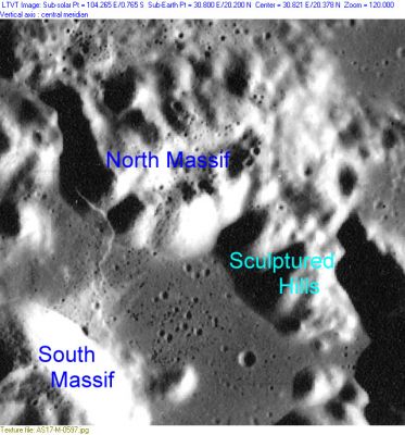
AS17-M-0597 The Apollo 17 landing site is roughly mid-way between the Sculptured Hills and South Massif.
Images
LPOD Photo Gallery Lunar Orbiter Images Apollo Images
- Four "forgotten" Hasselblads of the Sculptured hills, photographed one orbit before landing; AS17-147-22464, 22465, 22466, and 22467. The last one of those four (AS17-147-22467) was included on pages 292-293 of the article EXPLORING TAURUS-LITTROW by Harrison H. Schmitt (NATIONAL GEOGRAPHIC, september 1973). Research: Danny Caes
Sunrise circumstances at the western part of the Sculptured Hills near the Wessex Cleft
- A survey of surface photographs made by Gene Cernan and Jack Schmitt (Apollo 17, december 1972)
- The first photographs were made at sun's elevation 16 degrees, the last ones at sun's elevation 38 degrees
- Research: Danny Caes (- DannyCaes May 1, 2014)
EVA 1
- AS17-147-22505 (photographed from Station LM, EVA 1).
- AS17-147-22530, 22537, 22552, and 22563 (photographed from the ALSEP station, EVA 1).
- AS17-147-22577 (also photographed from the ALSEP station, part of the LRV, EVA 1).
- AS17-147-22599 and 22600 (also photographed from the ALSEP station, Gene Cernan drilling, EVA 1).
- AS17-136-20695 (also photographed from the ALSEP station, Gene Cernan extracting core, EVA 1).
- AS17-134-20408 and 20431 (photographed from Station 1 near Steno-Apollo crater, EVA 1).
- AS17-136-20758 (also photographed from Station 1 near Steno-Apollo crater, Gene Cernan at the LRV, EVA 1).
- AS17-136-20782, 20803, and 20815 (photographed during LRV traverse from Station 1 to Station SEP, EVA 1).
EVA 2
- AS17-137-20876 (photographed from Station LM, EVA 2).
- AS17-135-20568 (photographed during LRV traverse from Station SEP to Station 2, EVA 2).
- AS17-138-21039 (photographed from Station 2 near Nansen-Apollo crater, EVA 2).
- AS17-138-21077 and 21095 (photographed during LRV traverse from Station 2 to Station 2A, EVA 2).
- AS17-138-21113 (photographed during LRV traverse from Station 2A to Station 3, EVA 2).
- Magazine 144-R, which shows several 500 mm (northeast looking) close-ups of parts of the Sculptured Hills, made from Station 2A and Station 3 at the southwestern "corner" of the Taurus-Littrow valley (EVA 2).
- AS17-138-21165 (photographed from Station 3 near Lara crater, EVA 2).
- AS17-133-20196, 20202, 20217, 20224, 20226, and 20227 (photographed during LRV traverse from Station 3 to Station 4, EVA 2).
- AS17-133-20242 (photographed at Station 4 near Shorty crater, EVA 2).
- AS17-133-20272, 20275, 20298, and 20321 (photographed during LRV traverse from Station 4 to Station 5, EVA 2).
- AS17-133-20347 (photographed from Station 5 near Camelot crater, EVA 2).
- AS17-145-22159 and 22160 (also photographed from Station 5, at the boulder field near Camelot crater, EVA 2).
- AS17-133-20363 (photographed during LRV traverse from Station 5 to Station LM, EVA 2).
EVA 3
- AS17-140-21368 (photographed from Station LM, Jack Schmitt at the LRV, US flag, EVA 3).
- AS17-140-21388 (also photographed from Station LM, Gene Cernan at the LRV, US flag, EVA 3).
- AS17-141-21520 (photographed during LRV traverse from Station SEP to Station 6, EVA 3).
- AS17-141-21590 and 21592 (photographed from Station 6 near Split Rock, on the slope of the North Massif, EVA 3).
- AS17-140-21504 and 21505 (also photographed from Station 6 near Split Rock, EVA 3).
- Gene's Station 7 360 degrees panorama* shows the western part of the Sculptured Hills at left (to the "right" (east) of the North Massif)(EVA 3).
- Gene's Station 8 360 degrees panorama* shows the western part of the Sculptured Hills at extreme left (EVA 3).
- Jack's Station 8 360 degrees panorama* shows the slope of (the western part of) the Sculptured Hills (the "dome" in the central section of the panorama)(EVA 3).
- AS17-142-21813 (photographed from Station 9, Gene Cernan near Van Serg crater, EVA 3).
- AS17-143-21840 and 21841 (photographed from Station 9, EVA 3).
- AS17-146-22436, 22437, and 22438 (photographed from Station 9, EVA 3).
*Gene's 360 degrees panorama at Station 7: Hasselblad frames AS17-146-22339 to 22363 (ALSJ, 166:26:19).
*Gene's 360 degrees panorama at Station 8: Hasselblad frames AS17-146-22375 to 22397 (ALSJ, 167:07:50).
*Jack's 360 degrees panorama at Station 8: Hasselblad frames AS17-142-21726 to 21745 (ALSJ, 167:26:25).
Research Apollo 17 photography: Danny Caes
Sources:
LPI Apollo Image Atlas
ALSJ - Apollo Lunar Surface Journal (Eric M. Jones)
Exploring the Moon (David M. Harland)
Maps
(LAC zone 43D1) LAC map Geologic map LTO map
Description
Description: Wikipedia
Additional Information
The Landing Site Name "Sculptured Hills" is plotted on Topophotomap 43D1/S1 .
Nomenclature
Astronaut-named feature, Apollo 17 site.
  A tiny crater near the base of the Sculptured Hills seems to have been called Smith, another one near Apollo 17's Station 8 was called SWP (Science Working Panel). Source: APOLLO 17 Preliminary Science Report.- DannyCaes May 8, 2014
LPOD Articles
Bibliography
Harland, David M. Exploring the Moon; the Apollo expeditions (Springer, 1999).
