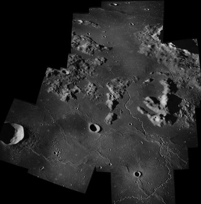
Rimae Herigonius
Contents
Rimae Herigonius
|
Lat: 13.0°S, Long: 37.0°W, Length: 100 km, Depth: km, Rükl 41 |

Apollo 16 (assembled Hasselblad photographs).
Southward orbital view of the Rimae Herigonius complex, Herigonius near the lower left corner, part of Gassendi at upper right, the odd Lobster (or Trilobite) formation at right. The Andreus Hills at left.
Images
LPOD Photo Gallery Lunar Orbiter Images Apollo Images
Maps
(LAC zone 75C4) LAC map Geologic map
Description
Description: Wikipedia
Additional Information
Nomenclature
- Named after the nearby crater (Herigonius).
- Number 7 in Debra Hurwitz'z Atlas and Catalog of Sinuous Rilles.
- This name appears on Chart E5 of the System of Lunar Craters Quad Maps (approved by the IAU in 1964). It was not part of the original IAU nomenclature of Blagg and Müller (1935).
- The cluster of hills and hillocks between Rimae Herigonius and Gassendi is sometimes nicknamed the Lobster or the Trilobite because of its peculiar and recognizable shape. Source: Akkana Peck.
- A wonderful telescopic photograph made by the dedicated lunar observer Bob Pilz, shows Rimae Herigonius, Herigonius itself, the Andreus hills, Gassendi, Clarkson (Gassendi A), and the recognizeable Lobster / Trilobite (above centre of photograph). - DannyCaes Dec 12, 2007
- Herigonius' Snake: the peculiar snake-shaped northeastern "extension" of Rimae Herigonius, at 11°45' South/ 35°45' West (at Dorsa Ewing). See upper part of Lunar Orbiter 4 frame 137-h2. Herigonius' Snake is also detectable on Chart 23 (page 59) in the 21st Century Atlas of the Moon (Wood/ Collins) at location 1-C (very near the chart's upper margin! Magnifying glass required!!!). Herigonius' Snake is thus nicknamed by Danny Caes
LPOD Articles
Threading the Pillars of Hercules
Making Rilles Visible.
Bibliography