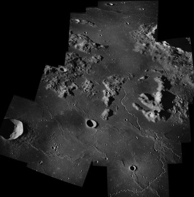
Herigonius
Contents
Herigonius
|
Lat: 13.3°S, Long: 33.9°W, Diam: 15 km, Depth: 2.1 km, Rükl: 41 |

Apollo 16
South Up view of the Herigonius - Andreus Hills region, with Herigonius itself at left, and the Andreus Hills south of it. At right the odd formation Lobster (or Trilobite), thus nicknamed by Akkana Peck (from the online Shallow Sky project and The Hitchhiker's Guide to the Moon).
Images
LPOD Photo Gallery Lunar Orbiter Images Apollo Images
- Herigonius Upsilon (or Herigonius Nu?), the arc-shaped hillock north-northeast of Herigonius itself (which is an interesting target for telescopic observers of the Herigonius region) was captured on Apollo 16's orbital panoramic ITEK-camera frame AS16-P-5464 (scroll rightward).
Research Danny Caes
Maps
(LAC zone 75C3) LAC map Geologic map
Description
Description: Elger
(IAU Directions) HERIGONIUS.--A ring-plain, about 7 miles in diameter, in the Mare Procellarum, N.E. of Gassendi. There is a small crater a few miles S.W. of it, among the bright little mountains which flank this formation. Herigonius has a small central mountain, which is a good test for moderate apertures.
Description: Wikipedia
Additional Information
- Depth data from Kurt Fisher database
Arthur, 1974: 2.1 km
Westfall, 2000: 2.1 km
Viscardy, 1985: 2.1 km
Cherrington, 1969: 1.7 km - Herigonius and its satellite craters E, EB and EC are on the ALPO list of bright ray craters
- Herigonius and Herigonius E and EC are thermal anomaly craters, implying youthful ages - Moore et al, 1980
A ridge, a rille?
- October 24th, 2017. Just discovered something which looks like an "upside-down" rille, or very thin ridge, at 11°30' South / 34°05' West (west of the arc-shaped hill Herigonius Nu, see the Big-Shadows WAC in the LROC QuickMap). - DannyCaes Oct 24, 2017 There's something similar south of Promontorium Laplace.
Nomenclature
- Herigone, Pierre; French mathematician, astronomer (fl. 1634).
  - Satellite crater Herigonius H was erroneously printed as HEROGONIUS H on LAC 93, page 187 in the REVISED AND UPDATED EDITION of the Clementine Atlas of the Moon, 2012, CAMBRIDGE UNIVERSITY PRESS.- DannyCaes Jan 10, 2013
Andreus Hills
- The cluster of hills and hillocks immediately south of Herigonius is sometimes known as the Andreus Hills. This rare name was printed on some moonmaps such as the large greenish colored Rand McNally moonmap and on the same map in Patrick Moore's Atlas of the Universe (1983). The origin of the (unofficial) name Andreus Hills is still a mystery (who was Andreus?). A list of other mysterious names on these moonmaps is online in the page Rand McNally. - DannyCaes Aug 30, 2015
- A small section of the Andreus Hills is often nicknamed Bibendum or Michelin Man (because of the curious appearance of an oversized human body with small head, small arms, small legs).
LPOD Articles
Making Rilles Visible.
Features of interest in a small area (the arc-shaped Herigonius Upsilon hillock (or Herigonius Nu?) north-northeast of Herigonius itself).
Bibliography