Pictet
Contents
[hide]Pictet
|
Lat: 43.6°S, Long: 7.4°W, Diam: 62 km, Depth: 1.78 km, Rükl 64 |
Images
LPOD Photo Gallery Lunar Orbiter Images Apollo Images
Maps
(LAC zone 112D2) LAC map Geologic map
Description
Description: Elger
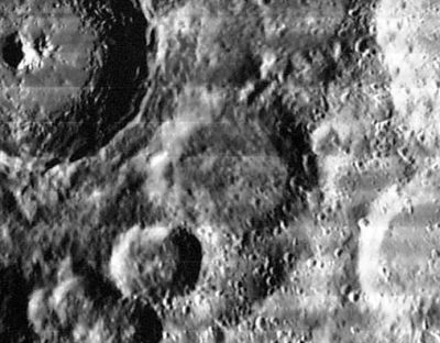
(IAU Directions) PICTET.--A walled-plain of irregular shape, about 30 miles across, between Saussure and Tycho, with a border broken on the S. by a large conspicuous ring-plain, which is at least 10 miles in diameter, and, according to Schmidt, has a central mountain. Schmidt draws the S.W. border of Pictet as broken by ridges extending on to the floor. He also shows several craters and minor elevations thereon.
Description: Wikipedia
Additional Information
Depth data from Kurt Fisher database
- Westfall, 2000: 1.78 km
- Viscardy, 1985: 2.7 km
- Cherrington, 1969: 2.28 km
>
The western inner slope of Pictet is a noteworthy telescopic target because of the curious bright hill-like and somewhat "cylindrical shaped" surface formation on it.
See LPOD What Do You See? and Pictet Puzzle
Nomenclature
Marc-Auguste Pictet-Turretin (July 23, 1752–April 19, 1825) was a Swiss physicist, chemist, meteorologist and astronomer. Pictet's scientific research was far ranging, but leaning towards natural sciences, such as astronomy, chronometry, but especially meteorology.
LPOD Articles
What Do You See? (the mysterious bright hill-like and somewhat "cylindrical shaped" surface formation on the western inner slope of Pictet).
Pictet Puzzle (close up of the object described in LPOD What Do You See?).
Bibliography
