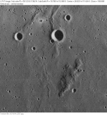
Mons Moro
Contents
Mons Moro (Bonpland Psi, in Mare Cognitum)
| Lat: 12.0°S, Long: 19.7°W, Diam: 10 km, Height: km, Rükl: 42 |
AS16-M-2207
Mons Moro (Bonpland Psi) is the hill to the bottom right of center. The largest of the craters in this view is 4-km Bonpland H. 3-km Bonpland J is to its west.
Images
LPOD Photo Gallery Lunar Orbiter Images Apollo Images
- There are no orbital Hasselblad color-photographs of Mons Moro (only B-and-W Fairchild and Itek photographs).
- Ranger 7 made a series of photographs of Mons Moro. One of the last frames on which Mons Moro was captured is A186. The largest of the craterlets in this frame are Bonpland H and J. The location of Mons Moro itself is near the image's lower right corner (the dark diagonal streak).
- Several of Apollo 16's panoramic Itek frames captured Mons Moro, such as AS16-P-5433.
- Research Ranger 7 and Apollo 16 photographs: Danny Caes
Maps
(LAC zone 76C4) LAC map Geologic map LM map
Description
- Mons Moro is a rather inconspicuous hill in the southeastern part of Mare Cognitum. It appears slightly darker than most other hills of similar size in the area.
Description: Wikipedia
Additional Information
- The unmanned probe Ranger 7 impacted northwest of Mons Moro (east-southeast of Kuiper).
- The USGS's Geologic Map of the Bonpland H region (I-693) shows the impact location of Ranger 7.
- The USGS's Geologic Map of the Bonpland PQC region (I-678) also shows the impact location of Ranger 7.
- Mons Moro looks very dark during Full Moon (it looks like a tiny dark spot), and I wonder if it is the darkest area on the entire moon's surface (?). It is located at the dark Mare Cognitum, which is adjacent to the equally dark Mare Nubium and the large dark region called Oceanus Procellarum.
- Note that there's another dark spot to the east-southeast of Mons Moro, which is the very rare cinder cone, located a little bit southwest of the bright craterlet Lassell D (west-northwest of Lassell and the "isle" near Lassell C). The cinder cone was investigated and photographed during the mission of Apollo 16 (by CMP Ken Mattingly, in orbit, aboard CSM Casper).
- Both dark spots (Mons Moro and the cinder cone near Lassell D) are interesting targets for today's webcam-photographers of small shadowless regions (during Full Moon).
- Most photographers of the Full Moon's disc are unaware of Mons Moro''s and the cinder cones dark appearances on their photographs. But... once they know the pinpoint locations of both the dark spots (in the eastern part of Mare Cognitum and to the east-southeast of it) they can't miss it! Good luck!
- Research: Danny Caes
Nomenclature
Antonio Lazzaro; Italian Earth scientist (1687-1764).
- The name Mons Moro was provisionally introduced on LTO-76C1. It does not appear to have been formerly named by the IAU. - Jim Mosher
- On chart SLC E5 (System of Lunar Craters, 1966) it was called "Psi" (a Greek letter designation) (probably this must have been Bonpland Psi, according to the nomenclature of the surrounding craters such as nearby Bonpland H and Bonpland J). - DannyCaes Apr 9, 2017
LPOD Articles
Bibliography
- APOLLO OVER THE MOON; A VIEW FROM ORBIT, Chapter 4: The Maria (Part 3), Figure 92 (stereo image).
- Shoemaker, Eugene M.; The Moon Close Up (photographs by Ranger 7, which impacted northwest of Mons Moro), National Geographic; november 1964.
