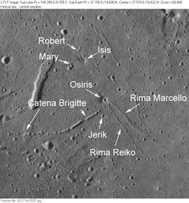
Catena Brigitte
Contents
[hide]Catena Brigitte
|
Lat: 18.5°N, Long: 27.5°E, Length: 5 km, Depth: km, Rükl: 24 |
AS17-M-0597 This small area northeast of Dawes, on the border between Mare Serenitatis and Mare Tranquillitatis, is densely populated with minor feature names because it was plotted on two of NASA's high-resolution Topophotomaps. The upper group of Robert, Mary and Isis appears on 42C3/S1 and the lower group of Osiris, Catena Brigitte, Rima Marcello, Rima Reiko and Jerik is on 42C3/S2.
Images
LPOD Photo Gallery Lunar Orbiter Images Apollo Images
Catena Brigitte was also captured on Apollo 15's orbital panoramic ITEK-camera frames AS15-P-9560/9565 (eastern part), AS15-P-9562/9567 (western part).
The large elongated depression northwest of Catena Brigitte (something which is observable through common telescopes, and was depicted by Antonin Rukl on chart 24 of his atlas) doesn't seem to have received an official IAU-name. Rather strange.
Apollo 17's low-sun ITEK frames AS17-P-2317 and 2322 show much more detail than the above mentioned high-sun frames of Apollo 15.
Research Apollo 15 and Apollo 17 photography: Danny Caes
Maps
(LAC zone 42C3) LAC map Geologic map LM map LTO map Topophotomap
Description
Description: Wikipedia
Additional Information
List of Lunar Catenae.
Nomenclature
French female name.
- According to NASA RP-1097, "Catena Brigitte" is a Minor Feature whose name was originally intended only for use in connection with Topophotomap 42C3/S2(on which it is plotted).
LPOD Articles
Bibliography
APOLLO OVER THE MOON; A VIEW FROM ORBIT, Chapter 4: The Maria (Part 3), Figure 90.
