Balboa
Contents
Balboa
|
Lat: 19.1°N, Long: 83.2°W, Diam: 69 km, Depth: 2.14 km, Rükl: 17 |
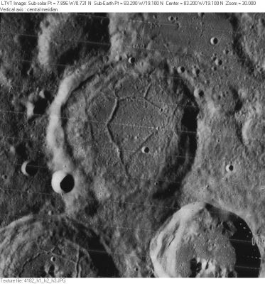
LO-IV-182H Balboa is in the center. The crater with the central peaks, partially visible in the lower right, is Balboa A. Just out of the field (below the peaks) it has a fascinating swirling flow pattern on its floor, similar to Abenezra. To its right is Dalton. The irregular enclosure to the northeast of Balboa is Balboa B. The 30-km diameter crater in the upper left is unnamed.
Images
LPOD Photo Gallery Lunar Orbiter Images Apollo Images
Zond 7 (Balboa and environs, evening light).
Maps
(LAC zone 37D3) USGS Digital Atlas PDF
Description
Description: Wikipedia
Additional Information
Depth data from Kurt Fisher database
- Westfall, 2000: 2.14 km
Balboa A central peak height
- Sekiguchi, 1972: 1 km - fatastronomer
The western part of Balboa shows some sort of "double rim" effect. This is a phenomenon which is not unique in these regions of the western "shoreline" of Oceanus Procellarum. Other examples which also show a "double rim" are: Krafft H and Krafft K, and especially Lavoisier C and Lavoisier T. - DannyCaes Aug 7, 2014
Nomenclature
- Vasco Núñez de Balboa (1475–January 15, 1519) was a Spanish explorer, governor, and conquistador. He travelled to the New World in 1500 and settled on the island of Hispaniola. He founded the settlement of Santa María la Antigua del Darién in present-day Panama in 1510, the first permanent European settlement on the mainland of the Americas. He crossed the Isthmus of Panama to the Pacific Ocean in 1513, becoming the first European to lead an expedition known to have seen or reached the Pacific from the New World.
- Name given by Arthur and Whitaker in Rectified Lunar Atlas (1963) and approved by IAU in 1964 (Whitaker, 1999, p234).
- Rimae Balboa (an unofficial name from D.Caes for the system of rilles on the floor of Balboa).
LPOD Articles
Bibliography
