Difference between revisions of "Geber"
(Created page with "<div id="content_view" class="wiki" style="display: block"> =Geber= {| class="wiki_table" | Lat: 19.4°S, Long: 13.9°E, Diam: 44 km, Depth: 3.51 km, [/R%C3%BCkl%2056 Rük...") |
|||
| Line 3: | Line 3: | ||
{| class="wiki_table" | {| class="wiki_table" | ||
| | | | ||
| − | Lat: 19.4°S, Long: 13.9°E, Diam: 44 km, Depth: 3.51 km, [ | + | Lat: 19.4°S, Long: 13.9°E, Diam: 44 km, Depth: 3.51 km, [[R%C3%BCkl%2056|Rükl: 56]]<br /> |
|} | |} | ||
<div id="toc"> | <div id="toc"> | ||
| Line 11: | Line 11: | ||
[http://www.lpod.org/coppermine/thumbnails.php?album=search&type=full&search=Geber LPOD Photo Gallery] [http://www.lpi.usra.edu/resources/lunar_orbiter/bin/srch_nam.shtml?Geber%7C0 Lunar Orbiter Images] [http://www.lpi.usra.edu/resources/apollo/search/feature/?feature=Geber Apollo Images]<br /> - '''Geber''' was also captured on several frames made by the southward looking mapping/metric ''Fairchild'' camera of Apollo 16, such as frame [http://www.lpi.usra.edu/resources/apollo/frame/?AS16-M-0701 AS16-M-0701], which shows '''Geber''' near the central part of the depicted curved horizon.<br /> - Research: Danny Caes<br /> <br /> | [http://www.lpod.org/coppermine/thumbnails.php?album=search&type=full&search=Geber LPOD Photo Gallery] [http://www.lpi.usra.edu/resources/lunar_orbiter/bin/srch_nam.shtml?Geber%7C0 Lunar Orbiter Images] [http://www.lpi.usra.edu/resources/apollo/search/feature/?feature=Geber Apollo Images]<br /> - '''Geber''' was also captured on several frames made by the southward looking mapping/metric ''Fairchild'' camera of Apollo 16, such as frame [http://www.lpi.usra.edu/resources/apollo/frame/?AS16-M-0701 AS16-M-0701], which shows '''Geber''' near the central part of the depicted curved horizon.<br /> - Research: Danny Caes<br /> <br /> | ||
==Maps== | ==Maps== | ||
| − | ''([ | + | ''([[LAC%20zone|LAC zone]] 96A1)'' [http://www.lpi.usra.edu/resources/mapcatalog/LAC/lac96/ LAC map] [http://www.lpi.usra.edu/resources/mapcatalog/usgs/I690/ Geologic map]<br /> <br /> |
==Description== | ==Description== | ||
<br /> | <br /> | ||
==Description: Elger== | ==Description: Elger== | ||
| − | ''([ | + | ''([[IAU%20Directions|IAU Directions]])'' GEBER.--A bright ring-plain, 25 miles in diameter, S. of [[Almanon|Almanon]], with a regular border, rising to a height on the E. of nearly 9,000 feet above the floor. There is a small crater on the crest of the S. wall, and another on the N. A ring-plain about 8 miles in diameter adjoins the formation on the N.W. According to Neison, there is a feeble central hill, which, however, is not shown by Schmidt.<br /> <br /> |
==Description: Wikipedia== | ==Description: Wikipedia== | ||
[http://en.wikipedia.org/wiki/Geber_(crater) Geber]<br /> <br /> | [http://en.wikipedia.org/wiki/Geber_(crater) Geber]<br /> <br /> | ||
==Additional Information== | ==Additional Information== | ||
| − | Depth data from [ | + | Depth data from [[Kurt%20Fisher%20crater%20depths|Kurt Fisher database]]<br /> |
* Westfall, 2000: 3.51 km | * Westfall, 2000: 3.51 km | ||
* Viscardy, 1985: 3.51 km | * Viscardy, 1985: 3.51 km | ||
Revision as of 15:49, 15 April 2018
Contents
Geber
|
Lat: 19.4°S, Long: 13.9°E, Diam: 44 km, Depth: 3.51 km, Rükl: 56 |
Table of Contents
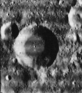
 LOIV 089 H2
Images
LPOD Photo Gallery Lunar Orbiter Images Apollo Images
- Geber was also captured on several frames made by the southward looking mapping/metric Fairchild camera of Apollo 16, such as frame AS16-M-0701, which shows Geber near the central part of the depicted curved horizon.
- Research: Danny Caes
Maps
(LAC zone 96A1) LAC map Geologic map
Description
Description: Elger
(IAU Directions) GEBER.--A bright ring-plain, 25 miles in diameter, S. of Almanon, with a regular border, rising to a height on the E. of nearly 9,000 feet above the floor. There is a small crater on the crest of the S. wall, and another on the N. A ring-plain about 8 miles in diameter adjoins the formation on the N.W. According to Neison, there is a feeble central hill, which, however, is not shown by Schmidt.
Description: Wikipedia
Additional Information
Depth data from Kurt Fisher database
- Westfall, 2000: 3.51 km
- Viscardy, 1985: 3.51 km
Nomenclature
Jabir ibn Aflah (Geber) (unknown-circa 1145) was a Spanish-Arab astronomer.
Note:
Not to be confused with Jabir ibn Hayyan (also known as Geber). ibn Hayyan was the LTO-name for Zwicky N on the moon's farside.
See also the Pseudo-Geber problem.
LPOD Articles
Bibliography
A Portfolio of Lunar Drawings (Harold Hill), pages 178, 179 (last stages of illumination on Geber, Almanon, and Abulfeda).
This page has been edited 1 times. The last modification was made by - tychocrater tychocrater on Jun 13, 2009 3:24 pm - afx3u2