Difference between revisions of "Chebyshev"
| Line 6: | Line 6: | ||
|- | |- | ||
| | | | ||
| − | [http://lpod.org/coppermine/displayimage.php?pid=4271&fullsize=1 [[Image: | + | [http://lpod.org/coppermine/displayimage.php?pid=4271&fullsize=1 [[Image:Normal_chebyshev-large.jpg|external image normal_chebyshev-large.jpg]]]<br /> |
| | | | ||
| − | [[Image: | + | [[Image:Chebyshev-color.jpg|chebyshev-color.jpg]]<br /> |
|} | |} | ||
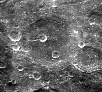
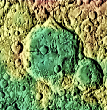
'''Left:''' ''[http://www.mapaplanet.org/explorer-bin/explorer.cgi?map=Moon&layers=moon_clementine_base_v2&info=NO&advoption=YES&sizeSelector=imageSize&lines=722&samples=1440&Resolution=34.816247582205&r=1&g=1&b=1&projection=SIMP&grid=none&stretch=auto&north=-39.63&south=-29.29&west=217.21&east=237.88¢er_lat=0¢er=227.545&defaultcenter=on Clementine] image. '''Right:''' [http://www.mapaplanet.org/explorer-bin/explorer.cgi?map=Moon&layers=lunar_lidar&west=217.21&south=-39.64&east=237.88&north=-29.28¢er_lat=0¢er=227.545&defaultcenter=on&grid=none&stretch=auto&projection=SIMP&advoption=YES&info=NO&resolution=69.6661828737301 Color-coded Lidar Topography] image. Both images from the [http://www.mapaplanet.org/explorer-bin/explorer.cgi?map=Moon&layers=moon_clementine_base_v2&info=NO&advoption=YES&lines=360&samples=720&sizeSelector=resolution&Resolution=2&projection=SIMP&grid=none&stretch=auto&resamp_method=nearest_neighbor&north=90&west=-180&east=180&south=-90¢er=0&defaultcenter=on¢er_lat=0 USGS Map-A-Planet]''<br /> <div id="toc"> | '''Left:''' ''[http://www.mapaplanet.org/explorer-bin/explorer.cgi?map=Moon&layers=moon_clementine_base_v2&info=NO&advoption=YES&sizeSelector=imageSize&lines=722&samples=1440&Resolution=34.816247582205&r=1&g=1&b=1&projection=SIMP&grid=none&stretch=auto&north=-39.63&south=-29.29&west=217.21&east=237.88¢er_lat=0¢er=227.545&defaultcenter=on Clementine] image. '''Right:''' [http://www.mapaplanet.org/explorer-bin/explorer.cgi?map=Moon&layers=lunar_lidar&west=217.21&south=-39.64&east=237.88&north=-29.28¢er_lat=0¢er=227.545&defaultcenter=on&grid=none&stretch=auto&projection=SIMP&advoption=YES&info=NO&resolution=69.6661828737301 Color-coded Lidar Topography] image. Both images from the [http://www.mapaplanet.org/explorer-bin/explorer.cgi?map=Moon&layers=moon_clementine_base_v2&info=NO&advoption=YES&lines=360&samples=720&sizeSelector=resolution&Resolution=2&projection=SIMP&grid=none&stretch=auto&resamp_method=nearest_neighbor&north=90&west=-180&east=180&south=-90¢er=0&defaultcenter=on¢er_lat=0 USGS Map-A-Planet]''<br /> <div id="toc"> | ||
Revision as of 02:44, 16 April 2018
Contents
Chebyshev
|
Lat: 33.7°S, Long: 133.1°W, Diam: 178 km, Depth: km, Rükl: (farside), pre-Nectarian | |
Images
LPOD Photo Gallery Lunar Orbiter Images Apollo Images
Frame 20, made by ZOND 8, shows Chebyshev near the frame's lower right corner.
Research: Danny Caes
Maps
(LAC zone 122A1) USGS Digital Atlas PDF
Description
Chebyshev is a 3.92 to 3.85 bn years old crater of the Nectarian-age . It lies within the north-eastern, outer ring sector of the South Pole Aitken Basin -- a 2500 kilometre-wide basin of the pre-Nectarian period (~ 4.6 to 3.92 bn years), some 200 km east of the Apollo Basin (pre-Nec -- 4.6 to 3.92 bn years old), and approximately 1000 km away from the Hetzsprung Basin (Nectarian) to its north. The crater itself shows a relatively worn-looking rim all around, with broken-up terracing seen particularly towards its northern and southern regions. The eastern and western sections have been affected by cratering impacts; most particularly the major impact event of Langmuir (91 km across) in the south-eastern sector. Besides the relatively flat-looking floor of Chebyshev having several small, numerous impact craters all around to speak of, two impact craters of note stand out -- that of the slightly distorted, assymetric shaped, 40 kilometer-wide crater to the south-east, and the other west of central. This latter crater shows sign of, perhaps, a deep-rooted, linear rille towards its western sector, or, is this simply due to several merged craters that formd a chain, or perhaps a fault section in the region? In fact, the above-mentioned craters may be the result of secondary crater impacts from the above-mentioned basin, Hertsrpung, or from the most early impact basin of them all -- that of Orientale, which lies easterly to Chebyshev some 1200 km away. - JohnMoore2 JohnMoore2
Description: Wikipedia
Additional Information
Nomenclature
- Chebyshev Z was officially approved by the IAU on the 25 July 2017 - JohnMoore2 JohnMoore2
- Pafnuty Lvovich Chebyshev (May 16, 1821 - December 8, 1894) was a Russian mathematician. Chebyshev is known for his work in the field of probability, statistics and number theory. Chebyshev is considered a founding father of Russian mathematics.
- An unnamed crater at 131° West/ 28° South (north-northeast of Chebyshev) was once called Rastorguev (crater N° 642 on this section of the Second Complete Moon Map, 1969 of the Shternberg Astronomy Institute). Research: Danny Caes.
- On the same moonmap's section, a crater immediately west of the above mentioned Rastorguev was once called Drashusov (N° 280). Research: Danny Caes.
LPOD Articles
Bibliography

