Wrottesley
Contents
Wrottesley
|
Lat: 23.9°S, Long: 56.8°E, Diam: 57 km, Depth: 4.23 km, Rükl: 59 |

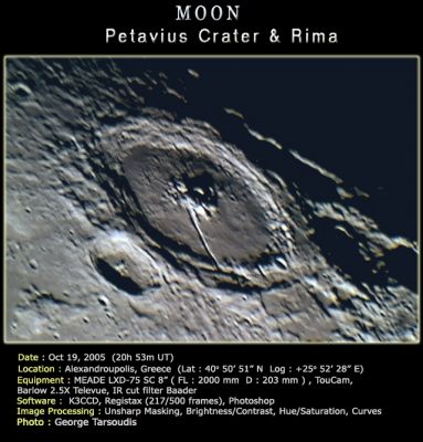
George Tasroudis (Wrottesley is crater in front of Petavius)
Images
LPOD Photo Gallery Lunar Orbiter Images
Wrottesley was photographed by Apollo 15's orbital Mapping/Metric Fairchild camera. This crater near Petavius is visible on Apollo 15's south looking oblique photographs. One such Fairchild frame is AS15-M-2527, in which Wrottesley was captured near the central part of the depicted curved horizon.
Research Danny Caes
Maps
(LAC zone 98A3) LAC map Geologic map
Description
Description: Elger
(IAU Directions) WROTTESLEY.--A formation, about 25 miles in diameter, closely associated with the W. wall of Petavius, the shape of which it has clearly modified. Its border on the W., of the linear type, rises nearly 9,000 feet above a light interior, where there is a small bright central mountain and some mounds. There is a prominent valley running along the inner slope of the E. wall.
Description: Wikipedia
Additional Information
- Depth data from Kurt Fisher database
- Westfall, 2000: 4.23 km
- Viscardy, 1985: 2.3 km
- Cherrington, 1969: 3.44 km
- Central Peak Height
- Sekiguchi, 1972: 1.4 km - fatastronomer
Nomenclature
- Named for John (Baron) Wrottesley (1798-1867), a British astronomer.
- The name was proposed by British amateur W. R. Birt in 1863, in commemoration of the interest the Baron had shown in astronomy.
LPOD Articles
Trenchent observations of a Trench Uninspiring, but an Active History Limb Gift
Bibliography
A Portfolio of Lunar Drawings (Harold Hill), page 216 (the Biot region).