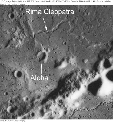
Rima Cleopatra
Contents
Rima Cleopatra
|
Lat: 30.0°N, Long: 53.8°W, Length: 14 km, Depth: km, Rükl: 8 |
AS15-M-2483 Other IAU-named features in this view include Aloha and parts of Montes Agricola and Rima Agricola in the lower right.
Images
LPOD Photo Gallery Lunar Orbiter Images
Maps
(LAC zone 38B2) LAC map Geologic map LM map LTO map Topophotomap
Description
Description: Wikipedia
Additional Information
- The typical width of Rima Cleopatra is 0.5 to 0.8 km, but it expands to an indefinite width to the east (at least 1.5 km before it fades).
Nomenclature
- Greek female name.
- Number 82 in Debra Hurwitz's Atlas and Catalog of Sinuous Rilles.
- According to NASA RP-1097, "Rima Cleopatra" is a Minor Feature whose name was originally intended only for use in connection with Topophotomap 38B2/S1(on which it is plotted).
- Because "Cleopatra" is regarded as a given name it does not honor any particular Cleopatra.
- Cleopatra (of Rima Cleopatra) is the most western one of the near side's small lunar formations which have generic "first names".- DannyCaes Jul 8, 2010
LPOD Articles
Bibliography
