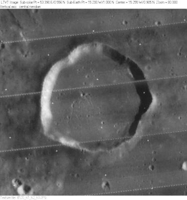
Gambart
Contents
Gambart
|
Lat: 1.0°N, Long: 15.2°W, Diam: 25 km, Depth: 1.1 km, Rükl: 32 |
Images
LPOD Photo Gallery Lunar Orbiter Images Apollo Images
Frame 1135, made by Lunar Orbiter 1, shows a detailed close-up of Gambart's floor and the craterlets on it. The distinct craterlet northwest of Gambart is Gambart EA.
Frame 1138 shows Gambart E' (top) and Gambart F (lower right corner); both to the west of Gambart itself.
Frame 3120, an oblique image made by Lunar Orbiter 3, shows Concentric Crater Gambart J and the area southwest of it. Gambart J is the 23th item in C.A.Wood's list of Concentric Craters (1978).
Frame 2112, made by Lunar Orbiter 2, shows a close-up of Gambart C (which is also known as Moreux)(see: Nomenclature, below).
Frame 120-h3, made by Lunar Orbiter 4, shows a vertical view of Concentric Crater Gambart J and its surroundings.
Gambart was also photographed during the mission of Apollo 16. It is seen on several orbital frames made by the Fairchild mapping/metric camera aboard CSM Caspers SIM-bay. Frame AS16-M-1418 shows Gambart a little bit "to the left" of the curved horizon's centre. Looking northward.
Additional research Lunar Orbiter and Apollo photography: Danny Caes
Maps
(LAC zone 58C4) LAC map Geologic map AIC map
Description
Description: Elger
(IAU Directions) GAMBART.--A regular ring-plain, 16 miles in diameter, with a low border and without visible detail within; situated nearly on the lunar equator, about 130 miles S.S.E. of Copernicus, at the N.E. edge of a very hilly region. A prominent pear-shaped mountain, with a small crater upon it, stands a short distance on the S.E., and further in the same direction, a large bright crater with two much smaller craters on the N. of it. The rough hilly district about midway between Copernicus and Gambart is remarkable for its peculiar dusky tone and for certain small dark spots, first seen by Schmidt, and subsequently carefully observed by Dr. Klein. The noteworthy region where these peculiar features are found represents an area of many thousand square miles, and must resemble a veritable Malpais, covered probably with an incalculable number of craters, vents, cones, and pits, filled with volcanic debris. It is among details of this character that the true analogues of some terrestrial volcanoes must be looked for. Under a low angle of illumination the surface presents an extraordinarily rough aspect, well worthy of examination, but the dusky areas and the black spots can only be satisfactorily distinguished under a somewhat high sun. I have, however, seen them fairly well when the E. wall of Reinhold was on the morning terminator.
Description: Wikipedia
Additional Information
- Depth data from Kurt Fisher database
- Pike, 1976: 1.1 km
- Arthur, 1974: 1.06 km
- Westfall, 2000: 1.1 km
- Viscardy, 1985: 1.05 km
- Cherrington, 1969: 1.09 km
- Cherrington, 1969: 0.82 km
- Gambart J concentric crater
- Satellite crater Gambart A is on the ALPO list of bright ray craters.
- Satellite craters Gambart A, B and C are on the ALPO list of banded craters
- Gambart L shows a curious radial system of dark bands ("spokes") on its inner slopes. See: Clementine's close-up, and also the LRO's low-res view of it at LON: -15.25, LAT: 3.25 (32 M/PIX), on the ACT-REACT Quick Map. - DannyCaes Jun 19, 2011
- According to several printed sources, the unmanned lander SURVEYOR 2 crashed slightly northeast of Gambart C (4° North/ 11° West). However, online sources show 4° SOUTH/ 11° West) (west of Lalande), and not 4° North/ 11° West. - DannyCaes Jan 31, 2013. See also: NASA-NSSDC source.
The two arcs
- About halfway between Gambart and Turner there's a curious system of two arc shaped hillocks of which the southern parts join together at a small bowl shaped crater. See: http://bit.ly/2wPDbXR- DannyCaes Aug 15, 2014
Nomenclature
- Jean-Félix Adolphe Gambart (May 12, 1800 – July 23, 1836) was a French astronomer. During his career he recorded a number of observations of the satellites of Jupiter, and discovered a total of 13 comets. In 1832 he observed the transit of Mercury across the Sun, noting that the planet appeared deformed as it approached the edge.
- This name was originally proposed by Mädler (Whitaker, p. 219).
- Gambart C, a bowl-shaped crater in Mare Insularum, was once known as Moreux. This was one of Felix Chemla Lamech's new names, but the I.A.U. did not accept the name Moreux.
- Research: Ewen A. Whitaker and Danny Caes (august 2003, mail correspondence).
- In Riccioli's nomenclature Gambart C was known as Dantes (a name no longer in use) (Whitaker, p. 212). - Jim Mosher
LPOD Articles
3.8 Billion Years of History Extreme Makeover (Gambart-type craters) Ups and Downs (Gambart B and C, and environs)
Bibliography
- Gambart C (Lamech's Moreux):
- Mapping and Naming the Moon; a history of lunar cartography and nomenclature (Ewen A. Whitaker).
- Named Lunar Formations (Mary Blagg).
