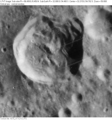
Stiborius
Contents
Stiborius
|
Lat: 34.4°S, Long: 32.0°E, Diam: 43 km, Depth: 3.75 km, Rükl: 67, Upper Imbrian |
LO-IV-076H Stiborius is in the upper left with 22-km Stiborius C partially visible in the upper right. The three kilometers arranged in a row in the lower right are (from the top) 10-km Stiborius C (closest to right margin), 7-km Stiborius M, and 8-km Stiborius F (partially visible at the bottom).
Images
LPOD Photo Gallery Lunar Orbiter Images Apollo Images
Maps
(LAC zone 113B2) LAC map Geologic map
Description
Description: Elger
(IAU Directions) STIBORIUS.--An elongated ring-plain, about 22 miles in diameter, S. of Piccolomini, with a lofty wall, broken in one place on the N. by a very conspicuous crater. Schmidt shows a distinct crater in the centre of the floor. I have only seen a central mountain in this position. There is a large crater on the N.E., a ring-plain on the S.E. side, and a multitude of little craters on the surrounding plain.
Description: Wikipedia
Additional Information
- Depth data from Kurt Fisher database
- Westfall, 2000: 3.75 km
- Viscardy, 1985: 3.7 km
- Cherrington, 1969: 3.41 km
- Central peak height
- From the shadows in LO-IV-090H, Stiborius is at least 3660 m deep, and its central peak is at least 1000 m tall. - Jim Mosher
- Sekiguchi, 1972: 1.0 km - fatastronomer fatastronomer
- Stiborius appears to lie on the eastern floor of a large unnamed older crater, about 90 km in diameter. - Jim Mosher
- Central peak composition: A & GNTA1 (Tompkins & Pieters, 1999)
- Stiborius and its satellite crater E are on the ALPO list of bright ray craters
Nomenclature
Stoberl, Andreas; German astronomer, mathematician (1465-1515).
- This name has continued unchanged since its original usage for this feature on Riccioli's map (Whitaker, p. 215).
LPOD Articles
Bibliography
