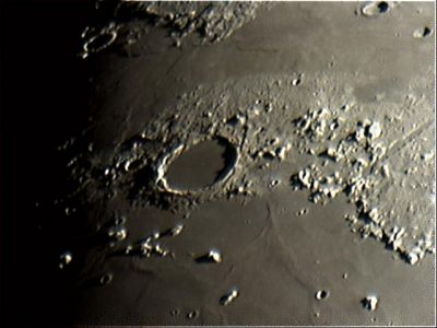
Mons Pico
Contents
[hide]- 1 Mons Pico
- 1.1 Images
- 1.2 Mons Pico in paintings and drawings
- 1.3 Maps
- 1.4 Description
- 1.5 Description: Elger
- 1.6 Description: Wikipedia
- 1.7 Additional Information
- 1.8 Nomenclature
- 1.9 LPOD Articles
- 1.10 Lunar 100
- 1.11 Bibliography
- 1.12 Walter H. Haas (the IAU's Pico E) in the Sourcebook Project (William R. Corliss)
Mons Pico
(current IAU name; former name: Pico)
|
Lat: 45.7°N, Long: 8.9°W, Diam: 25 km, Height: 2.4 km, Rükl 11 |

Helmut Groell, Plato, Mons Pico (south of Plato) and Mons Piton (lower right)
Images
LPOD Photo Gallery Lunar Orbiter Images Kaguya HDTV
- A wonderful three-dimensional look at both Mons Pico and Pico Beta (south of Mons Pico) could be created while exploring extreme close-up images of both mountains via the ASU's zoom-able scans of Apollo 15's oblique north-looking metric/mapping Fairchild-camera photographs AS15-M-1543 and AS15-M-1544. While looking with the left eye at frame 1544's close up of both mountains, and the right eye at frame 1543's close up (via the parallel viewing technique), one could easily see how Pico Beta is located "in front" of the distant Mons Pico. A remarkable stereoscopic effect!
Note: in both frames the Pico-mountains are located at the curved horizon.
Research stereoscopy in orbital Apollo 15 photography: Danny Caes
Mons Pico in paintings and drawings
Willy Ley's book The Conquest of Space (1951) shows a wonderful Pico-illustration painted by Chesley Bonestell. This illustration shows an orbital "flyover" of Mons Pico and nearby Montes Teneriffe, with shadowed crater Plato in the distance. The Dutch translated version of this book (De Sprong in het Heelal, 1951) shows this painting as Plate XXIVb, between pages 38 and 39.
 - DannyCaes Apr 16, 2012
Maps
(LAC zone 25A1) LAC map Geologic map
Description
Description: Elger
(IAU Directions) PICO.--A magnificent isolated mountain, S. of Plato, in N. lat. 45 deg., W. long. 9 deg., rising some 8,000 feet above the Mare Imbrium.
Description: Wikipedia
Additional Information
- Depth data from Kurt Fisher database
- Viscardy, 1985: 2.4 km
- Cherrington, 1969: 2.43 km
- Mons Pico Beta (1.901° W and 38.389° N) rises 1900 m above Mare Imbrium as measured by the Brandon Valley High School astronomy class and reported in Selenology vol. 24, no. 3 (Autumn 2005).- fatastronomer fatastronomer
- Profiles of Mons Pico and Mons Pico Beta were published by Steve Boint in the Spring 2007 issue of Selenology: Journal of the American Lunar Society. - fatastronomer fatastronomer
Nomenclature
- According to the IAU Planetary Gazetteer, Pico is simply Spanish for "peak".
- The name Pico was introduced by Johann Schröter, who repeatedly compares it to "Pico aus Tenerifa" or "Pico von Tenerifa", probably reference to Pico del Teide, the highest point in Tenerife.
- In the original IAU nomenclature of Blagg and Müller (1935), the name was simply Pico.
- The name was evidently Latinized to Mons Pico at some later date, but the change does not seem to have been officially recorded in the IAU Transactions.
- Crater Pico B was called Reese by Wilkins and Moore, but the IAU did not accept that name. Elmer Reese was a prominent member of the ALPO in the 1950s and 60s.
- Crater Pico E was once known as Dupont (a name proposed by Felix Chemla Lamech).
- Pico E was also known as Haas (a name proposed by Wilkins and Moore). Walter H. Haas (1917-2015) was a leader of American amateur astronomers from the 1940s onward. He was the founder of the ALPO (see: Sky and Telescope, December 1993, page 100).
- Neither name (Dupont and Haas) was accepted by the IAU.
- Research Lamech's Dupont: Ewen A. Whitaker and Danny Caes (august 2003, mail correspondence).
- Research Wilkins's Haas and Reese: Danny Caes and Claude Libert (Claude's book THE MOON by H.P.Wilkins and P.Moore).
- The incomplete and ghost-crater like ring between Mons Pico and Plato is sometimes called Ancient Newton because Schröter used the name Newton for this feature before Beer and Mädler decided it was more appropriate to move that name to its present location.
- Pico Beta (south of Mons Pico) was once called Pitati by Langrenus, and Insula Ebissus by Hevelius (source: Mapping and Naming the Moon, by E.A.Whitaker).
- Rima Pico C (a lunar enthusiast's name for the rille north-northwest of the bowl-shaped crater Pico C) (see: http://bit.ly/2xKGbDq ).
LPOD Articles
Everything is Here (High-Resolution telescopic photograph of the Ancient Newton region, by Christian Viladrich).
Lunar 100
L23: Isolated Imbrium basin-ring fragment.
Bibliography
- Dupont/ Haas (Pico E): Mapping and Naming the Moon; a history of lunar cartography and nomenclature (Ewen A. Whitaker).
- The Moon (Hugh Percy Wilkins and Patrick Moore).
- A Portfolio of Lunar Drawings (Harold Hill), pages 62, 65, 66.
Walter H. Haas (the IAU's Pico E) in the Sourcebook Project (William R. Corliss)
- In Mysterious Universe, a handbook of astronomical anomalies (1979) :
- Page 240: Does Anything Ever Happen on the Moon? (Walter H. Haas, Journal of the Royal Astronomical Society of Canada, 1942)