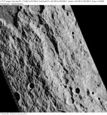
Vallis Bouvard
Contents
Vallis Bouvard
(current IAU name; original IAU name: Bouvard)
|
Lat: 38.3°S, Long: 83.1°W, Length: 284 km, Depth: km, Rükl: 61 |
LO-IV-186H Vallis Bouvard is the snake-like form slithering across the center of the image.
Images
LPOD Photo Gallery Lunar Orbiter Images
Maps
(LAC zone 109A4)
Description
Description: Elger
(IAU Directions) BOUVARD.--A great irregular enclosure, which appears to be still larger than Lagrange, S.W. of Piazzi, and close to the limb. It is bounded by a very lofty rampart, rising at a peak on the E. to 10,000 feet. It has a fine central mountain.
Description: Wikipedia
Additional Information
Nomenclature
- Named for Alexis Bouvard (1767-1843), a French astronomer and mathematician.
- Bouvard was listed as a Catalog Entry 2240 in Mary Blagg's Collated List of 1913.
- The original IAU nomenclature of Blagg and Müller included Bouvard as well as ten lettered craters and four Greek-lettered peaks named after it. Bouvard was listed as an 80-km diameter "ring plain" (crater). The name is attributed to Mädler.
- The name was changed from Bouvard to Vallis Bouvard as part of the re-naming of vaguely defined features in the Mare Orientale region announced in Menzel, 1971.
LPOD Articles
Bumpy, Lumpy, and Where? (see this LPOD's discussion).
Bibliography
Harold Hill. 1991. A Portfolio of Lunar Drawings pages 166, 167 (the Baade-Inghirami-Bouvard valleys).
