Rost
Contents
Rost
|
Lat: 56.4°S, Long: 33.7°W, Diam: 48 km, Depth: 2.46 km, Rükl: 71 |
Table of Contents
[#Rost Rost]
[#Rost-Images Images]
[#Rost-Maps Maps]
[#Rost-Description Description]
[#Rost-Description: Elger Description: Elger]
[#Rost-Description: Wikipedia Description: Wikipedia]
[#Rost-Additional Information Additional Information]
[#Rost-Nomenclature Nomenclature]
[#Rost-LPOD Articles LPOD Articles]
[#Rost-Bibliography Bibliography]

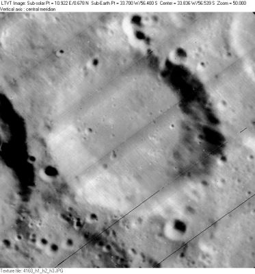
LO-IV-160H The crater partly visible on the left is 39-km Rost A. The 6-km crater outside the rim at 5 o’clock is Rost N.
Images
LPOD Photo Gallery Lunar Orbiter Images Apollo Images
Maps
(LAC zone 125C1) LAC map Geologic map
Description
Description: Elger
(IAU Directions) ROST.--An oblong-shaped ring-plain, 30 miles in diameter, on the S.E. of Schiller, with moderately high walls, and, according to Neison, a shallow depression within, nearly central. I have seen a crater shown by Schmidt on the W. side of the floor. A valley runs from the W. side of Rost to the S. of Schiller.
Description: Wikipedia
Additional Information
Depth data from Kurt Fisher database
- Westfall, 2000: 2.46 km
- Viscardy, 1985: 2 km
- Cherrington, 1969: 2.49 km
Nomenclature
- Named for Johann Leonhard Rost (1688-1727), a German astronomer.
- According to Whitaker (p. 218), this name was introduced by Schröter, who himself got the name from a list prepared by Hell, where it appeared in the form Rostius and referred to a different crater (p. 93).
- Illustrations - many of the Moon - from Rost's Astronomical Handbook of 1718.
LPOD Articles
Bibliography
This page has been edited 1 times. The last modification was made by - tychocrater tychocrater on Jun 13, 2009 3:24 pm - afx4