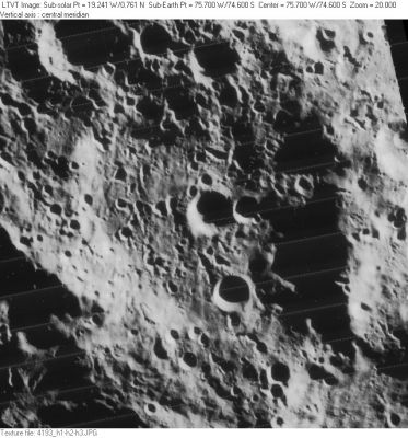
Le Gentil
Contents
Le Gentil
|
Lat: 74.6°S, Long: 75.7°W, Diam: 128 km, Depth: km, Rükl 72 |
Table of Contents
[#Le Gentil Le Gentil]
[#Le Gentil-Images Images]
[#Le Gentil-Maps Maps]
[#Le Gentil-Description Description]
[#Le Gentil-Description: Elger Description: Elger]
[#Le Gentil-Description: Wikipedia Description: Wikipedia]
[#Le Gentil-Additional Information Additional Information]
[#Le Gentil-Nomenclature Nomenclature]
[#Le Gentil-LPOD Articles LPOD Articles]
[#Le Gentil-Bibliography Bibliography]

LO-IV-193H
Images
LPOD Photo Gallery Lunar Orbiter Images Apollo Images
Maps
(LAC zone 136D1) USGS Digital Atlas PDF
Description
Description: Elger
(IAU Directions) LEGENTIL.--A large walled-plain, close to the limb, S. of Bailly.
Description: Wikipedia
Additional Information
- The shadows in LO-IV-193H, suggest that at some points the east rim of Le Gentil is more than 5000 m above the floor. - JimMosher JimMosher
- The southeastern sunlit inner slope of Le Gentil A is partially visible near the lower right corner of this photograph which shows the region along the 50° West meridian at LAC 136 in the Clementine Atlas (looking southward). The "flap" which is hanging off the lady's table is located at 75° South/ 50° West. Research: Danny Caes and John Moore.
Nomenclature
- Named for Guillaume Hyazinthe Le Gentil (1725-1792), a French astronomer. One of his interesting findings was that the duration of the lunar eclipse of 30 August 1765 was predicted by a Tamil astronomer, based on the computation of the size and extent of the earth-shadow (going back to Aryabhata, 5th c.), and was found short by 41 seconds, whereas the charts of Tobias Mayer were long by 68 seconds.
- This feature was catalog entry 2665 in the original IAU nomenclature of Blagg and Müller, where it is spelled Legentil. The name is attributed to Schröter.
- Kuiper (in his Photographic Lunar Atlas) suggested the position shown in the IAU's Named Lunar Formations charts was imprecise, and revised the location to correspond to the "original authority" (Schröter). The positional changes in the Photographic Lunar Atlas were approved in 1961, at which time the IAU also changed the spelling to Le Gentil. - JimMosher JimMosher
LPOD Articles
Bibliography
This page has been edited 1 times. The last modification was made by - tychocrater tychocrater on Jun 13, 2009 3:24 pm - afx3u2