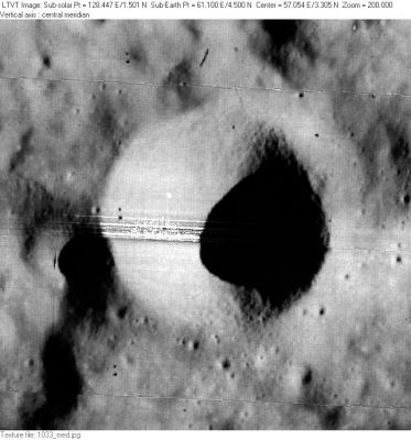
Ameghino
Contents
Ameghino
(formerly Apollonius C)
|
Lat: 3.3°N, Long: 57.0°E, Diam: 9 km, Depth: 1.87 km, Rükl: 38 |
Table of Contents
[#Ameghino Ameghino]
[#Ameghino-Images Images]
[#Ameghino-Maps Maps]
[#Ameghino-Description Description]
[#Ameghino-Description: Wikipedia Description: Wikipedia]
[#Ameghino-Additional Information Additional Information]
[#Ameghino-Nomenclature Nomenclature]
[#Ameghino-LPOD Articles LPOD Articles]
[#Ameghino-Bibliography Bibliography]

LO-I-033M
Images
LPOD Photo Gallery Lunar Orbiter Images Apollo Images
- Ameghino was also captured on Apollo 17's panoramic ITEK-camera frames AS17-P-2927 and AS17-P-2932. You don't have to scroll your way toward the right parts of the frames, because Ameghino is already visible near the right margin of your screen! (the bright crater with the cone-shaped inner slopes).
- Research: Danny Caes
Maps
(LAC zone 62D3) LAC map Geologic map LM map LTO map
Description
Description: Wikipedia
Additional Information
- Depth data from Kurt Fisher database
- Westfall, 2000: 1.87 km
- From the shadows in LO-I-033M, Ameghino is about 1800 m deep. - JimMosher JimMosher
Nomenclature
- Named for Fiorino (or Florentino) Ameghino (1854-1911), an Argentine paleontologist and anthropologist.
- The name Apollonius C was part of the original IAU nomenclature of Blagg and Müller (Catalog Entry 69). The name is attributed to Neison, and it is noted to be different from Mädler's Apollonius C .
- This replacement name for a formerly lettered crater was introduced on LTO-62D3 (for which it served as the chart title). The new name was approved as assigned in 1976 (IAU Transactions XVIB). - JimMosher JimMosher
LPOD Articles
Bibliography
This page has been edited 1 times. The last modification was made by - tychocrater tychocrater on Jun 13, 2009 3:24 pm - afx3u2