Jomo
Contents
Jomo
|
Lat: 24.41°N, Long: 2.44°E, Diam: 7.36 km, Depth: km, Rükl: 22 |
Table of Contents
[#Jomo Jomo]
[#Jomo-Images Images]
[#Jomo-Maps Maps]
[#Jomo-Description Description]
[#Jomo-Description-Wikipedia Wikipedia]
[#Jomo-Additional Information Additional Information]
[#Jomo-Nomenclature Nomenclature]
[#Jomo-LPOD Articles LPOD Articles]
[#Jomo-Bibliography Bibliography]

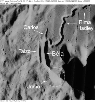
LO-V-105M Jomo is one of several pits at the southeast end of Rima Hadley, the other IAU-named ones being Béla, Carlos and Taizo. The white circle in this image represents the IAU position and diameter of Jomo, but the lighting makes it much harder to see than the others. For a clearer representation of Jomo see the Apollo Topophotomap or the LRO ACT-REACT Quickmap.
Images
LPOD Photo Gallery Lunar Orbiter Images Apollo Images
Maps
(LAC zone 41B4) LAC map Geologic map LM map LTO map Topophotomap
Description
Wikipedia
Additional Information
- IAU page: Jomo
- Warning: In certain digital lunar atlases, the location of Jomo is erroneously positioned at 1° 36' West, instead of 2.4° East.- DannyCaes DannyCaes Jan 23, 2010
- Is Jomo (and its adjacent curved formations Béla,Carlos, and Taizo) part of a much larger circular feature which is located slightly to the east? - DannyCaes DannyCaes Jan 23, 2010
Nomenclature
- Jomo is an African male name, honoring no specific person.
- According to NASA RP-1097, "Jomo" is a Minor Feature whose name was originally intended only for use in connection with Topophotomap 41B4/S3 (on which it is plotted).
LPOD Articles
Watching the other rilles (vent V1: Jomo)
Bibliography
Named Features -- Prev: Joliot -- Next: José
This page has been edited 1 times. The last modification was made by - tychocrater tychocrater on Jun 13, 2009 3:24 pm - afx3u3