Difference between revisions of "Poisson"
(Created page with "<div id="content_view" class="wiki" style="display: block"> =Poisson= {| class="wiki_table" | Lat: 30.4°S, Long: 10.6°E, Diam: 42 km, Depth: 1.73 km, [/R%C3%BCkl%2066 R...") |
|||
| Line 3: | Line 3: | ||
{| class="wiki_table" | {| class="wiki_table" | ||
| | | | ||
| − | Lat: 30.4°S, Long: 10.6°E, Diam: 42 km, Depth: 1.73 km, [ | + | Lat: 30.4°S, Long: 10.6°E, Diam: 42 km, Depth: 1.73 km, [[R%C3%BCkl%2066|Rükl: 66]]<br /> |
|} | |} | ||
<div id="toc"> | <div id="toc"> | ||
| Line 11: | Line 11: | ||
[http://www.lpod.org/coppermine/thumbnails.php?album=search&type=full&search=Poisson LPOD Photo Gallery] [http://www.lpi.usra.edu/resources/lunar_orbiter/bin/srch_nam.shtml?Poisson%7C0 Lunar Orbiter Images] [http://www.lpi.usra.edu/resources/apollo/search/feature/?feature=Poisson Apollo Images]<br /> <br /> | [http://www.lpod.org/coppermine/thumbnails.php?album=search&type=full&search=Poisson LPOD Photo Gallery] [http://www.lpi.usra.edu/resources/lunar_orbiter/bin/srch_nam.shtml?Poisson%7C0 Lunar Orbiter Images] [http://www.lpi.usra.edu/resources/apollo/search/feature/?feature=Poisson Apollo Images]<br /> <br /> | ||
==Maps== | ==Maps== | ||
| − | ''([ | + | ''([[LAC%20zone|LAC zone]] 96D4)'' [http://www.lpi.usra.edu/resources/mapcatalog/LAC/lac96/ LAC map] [http://www.lpi.usra.edu/resources/mapcatalog/usgs/I690/ Geologic map]<br /> <br /> |
==Description== | ==Description== | ||
<br /> | <br /> | ||
==Description: Elger== | ==Description: Elger== | ||
| − | ''([ | + | ''([[IAU%20Directions|IAU Directions]])'' POISSON.--An irregular formation on the E. of [[Aliacensis|Aliacensis]], extending about 50 miles from E. to W., but much less in a meridional direction. Its N. limits are marked by a number of overlapping ring-plains and craters, and it is much broken elsewhere by smaller depressions. The W. wall is about 7,000 feet in height.<br /> <br /> |
==Description: Wikipedia== | ==Description: Wikipedia== | ||
[http://en.wikipedia.org/wiki/Poisson_(crater) Poisson]<br /> <br /> | [http://en.wikipedia.org/wiki/Poisson_(crater) Poisson]<br /> <br /> | ||
==Additional Information== | ==Additional Information== | ||
| − | Depth data from [ | + | Depth data from [[Kurt%20Fisher%20crater%20depths|Kurt Fisher database]]<br /> |
* Westfall, 2000: 1.73 km | * Westfall, 2000: 1.73 km | ||
| − | * Satellite craters Poisson C and K are on the [ | + | * Satellite craters Poisson C and K are on the [[ALPO%20list%20of%20banded%20craters|ALPO list of banded craters]] |
==Nomenclature== | ==Nomenclature== | ||
Revision as of 15:08, 15 April 2018
Contents
Poisson
|
Lat: 30.4°S, Long: 10.6°E, Diam: 42 km, Depth: 1.73 km, Rükl: 66 |
Table of Contents
[#Poisson Poisson]
[#Poisson-Images Images]
[#Poisson-Maps Maps]
[#Poisson-Description Description]
[#Poisson-Description: Elger Description: Elger]
[#Poisson-Description: Wikipedia Description: Wikipedia]
[#Poisson-Additional Information Additional Information]
[#Poisson-Nomenclature Nomenclature]
[#Poisson-LPOD Articles LPOD Articles]
[#Poisson-Bibliography Bibliography]

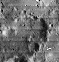
LO iv96-h1
Images
LPOD Photo Gallery Lunar Orbiter Images Apollo Images
Maps
(LAC zone 96D4) LAC map Geologic map
Description
Description: Elger
(IAU Directions) POISSON.--An irregular formation on the E. of Aliacensis, extending about 50 miles from E. to W., but much less in a meridional direction. Its N. limits are marked by a number of overlapping ring-plains and craters, and it is much broken elsewhere by smaller depressions. The W. wall is about 7,000 feet in height.
Description: Wikipedia
Additional Information
Depth data from Kurt Fisher database
- Westfall, 2000: 1.73 km
- Satellite craters Poisson C and K are on the ALPO list of banded craters
Nomenclature
- Siméon-Denis Poisson (June 21, 1781 – April 25, 1840), was a French mathematician, geometer, and physicist. It was in the application of mathematics to physical subjects that his greatest services to science were performed. Perhaps the most original, and certainly the most permanent in their influence, were his memoirs on the theory of electricity and magnetism, which virtually created a new branch of mathematical physics.
- Poisson Alpha (mountain-like elevation south of Poisson A) (see page 138 in Tony Dethier's Maanmonografieen).
LPOD Articles
Bibliography
This page has been edited 1 times. The last modification was made by - tychocrater tychocrater on Jun 13, 2009 3:24 pm - afx3u2