Difference between revisions of "Mons Hadley Delta"
(Created page with "<div id="content_view" class="wiki" style="display: block"> =Mons Hadley Delta= {| class="wiki_table" | Lat: 25.8°N, Long: 3.8°E, Diam: 15 km, Height: km, [/R%C3%BCkl%20...") |
|||
| Line 3: | Line 3: | ||
{| class="wiki_table" | {| class="wiki_table" | ||
| | | | ||
| − | Lat: 25.8°N, Long: 3.8°E, Diam: 15 km, Height: km, [ | + | Lat: 25.8°N, Long: 3.8°E, Diam: 15 km, Height: km, [[R%C3%BCkl%2022|Rükl: 22]]<br /> |
|} | |} | ||
<div id="toc"> | <div id="toc"> | ||
=Table of Contents= | =Table of Contents= | ||
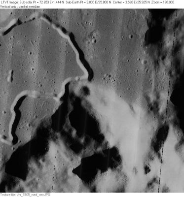
| − | <div style="margin-left: 1em">[#Mons Hadley Delta Mons Hadley Delta]</div><div style="margin-left: 2em">[#Mons Hadley Delta-Images Images]</div><div style="margin-left: 2em">[#Mons Hadley Delta-Maps Maps]</div><div style="margin-left: 2em">[#Mons Hadley Delta-Description Description]</div><div style="margin-left: 2em">[#Mons Hadley Delta-Description: Wikipedia Description: Wikipedia]</div><div style="margin-left: 2em">[#Mons Hadley Delta-Additional Information Additional Information]</div><div style="margin-left: 2em">[#Mons Hadley Delta-Nomenclature Nomenclature]</div><div style="margin-left: 2em">[#Mons Hadley Delta-APOD Articles APOD Articles]</div><div style="margin-left: 2em">[#Mons Hadley Delta-Bibliography Bibliography]</div></div>[http://www.lpod.org/coppermine/albums/userpics/Mons_Hadley_Delta_LO-V-105M_LTVT.JPG [[Image:normal_Mons_Hadley_Delta_LO-V-105M_LTVT.JPG|external image normal_Mons_Hadley_Delta_LO-V-105M_LTVT.JPG]]]<br /> ''[http://lpod.org/coppermine/displayimage.php?pos=-2986 LO-V-105M]'' '''Mons Hadley Delta''' is the roughly circular mountain mass just below center, with the 2-km [ | + | <div style="margin-left: 1em">[#Mons Hadley Delta Mons Hadley Delta]</div><div style="margin-left: 2em">[#Mons Hadley Delta-Images Images]</div><div style="margin-left: 2em">[#Mons Hadley Delta-Maps Maps]</div><div style="margin-left: 2em">[#Mons Hadley Delta-Description Description]</div><div style="margin-left: 2em">[#Mons Hadley Delta-Description: Wikipedia Description: Wikipedia]</div><div style="margin-left: 2em">[#Mons Hadley Delta-Additional Information Additional Information]</div><div style="margin-left: 2em">[#Mons Hadley Delta-Nomenclature Nomenclature]</div><div style="margin-left: 2em">[#Mons Hadley Delta-APOD Articles APOD Articles]</div><div style="margin-left: 2em">[#Mons Hadley Delta-Bibliography Bibliography]</div></div>[http://www.lpod.org/coppermine/albums/userpics/Mons_Hadley_Delta_LO-V-105M_LTVT.JPG [[Image:normal_Mons_Hadley_Delta_LO-V-105M_LTVT.JPG|external image normal_Mons_Hadley_Delta_LO-V-105M_LTVT.JPG]]]<br /> ''[http://lpod.org/coppermine/displayimage.php?pos=-2986 LO-V-105M]'' '''Mons Hadley Delta''' is the roughly circular mountain mass just below center, with the 2-km [[St.%20George|St. George]] crater on its northwest flank, and the flat plains of [[Palus%20Putredinis|Palus Putredinis]] beyond. The rille snaking across the plain is a small part of [[Rima%20Hadley|Rima Hadley]], and the [[Apollo%2015%20Site|Apollo 15 Site]] is to its right. Around the landing site, the [[South%20Cluster|South Cluster]] of craters and the unexplored [[North%20Complex|North Complex]] (with its suspected volcanic extrusions) are easily recognized; as is (on the opposite side of [[Rima%20Hadley|Rima Hadley]]) the elongated trough of 2-km [[Julienne|Julienne]] (near the center left margin).<br /> <br /> |
==Images== | ==Images== | ||
[http://www.lpod.org/coppermine/thumbnails.php?album=search&type=full&search=Mons%20Hadley%20Delta LPOD Photo Gallery] [http://www.lpi.usra.edu/resources/lunar_orbiter/bin/srch_nam.shtml?Mons%20Hadley%20Delta%7C0 Lunar Orbiter Images] [http://www.lpi.usra.edu/resources/apollo/search/feature/?feature=Mons%20Hadley%20Delta Apollo Images]<br /> | [http://www.lpod.org/coppermine/thumbnails.php?album=search&type=full&search=Mons%20Hadley%20Delta LPOD Photo Gallery] [http://www.lpi.usra.edu/resources/lunar_orbiter/bin/srch_nam.shtml?Mons%20Hadley%20Delta%7C0 Lunar Orbiter Images] [http://www.lpi.usra.edu/resources/apollo/search/feature/?feature=Mons%20Hadley%20Delta Apollo Images]<br /> | ||
| Line 13: | Line 13: | ||
<br /> | <br /> | ||
==Maps== | ==Maps== | ||
| − | ''([ | + | ''([[LAC%20zone|LAC zone]] 41B4)'' [http://www.lpi.usra.edu/resources/mapcatalog/LAC/lac41/ LAC map] [http://www.lpi.usra.edu/resources/mapcatalog/usgs/I463/ Geologic map] [http://www.lpi.usra.edu/resources/mapcatalog/LM/lm41/ LM map] [http://www.lpi.usra.edu/resources/mapcatalog/LTO/lto41b4_2/ LTO map]<br /> <br /> |
==Description== | ==Description== | ||
<br /> | <br /> | ||
| Line 22: | Line 22: | ||
==Nomenclature== | ==Nomenclature== | ||
| − | * Named after the larger nearby mountain. ([ | + | * Named after the larger nearby mountain. ([[Mons%20Hadley|Mons Hadley]]) |
* '''Subsidiary Peak''' (a name?). This peak's location is southwest of '''Mount Hadley Delta''', see [http://www.hq.nasa.gov/alsj/a15/a15HadleyC.jpg labeled orbital photograph] (ALSJ). | * '''Subsidiary Peak''' (a name?). This peak's location is southwest of '''Mount Hadley Delta''', see [http://www.hq.nasa.gov/alsj/a15/a15HadleyC.jpg labeled orbital photograph] (ALSJ). | ||
* Strange to say, the name '''Hadley Delta''' (or '''Mons Hadley Delta''', or just the Greek letter '''Delta''') is not mentioned on Chart 29 in the ''Times Atlas of the Moon''. | * Strange to say, the name '''Hadley Delta''' (or '''Mons Hadley Delta''', or just the Greek letter '''Delta''') is not mentioned on Chart 29 in the ''Times Atlas of the Moon''. | ||
Revision as of 15:04, 15 April 2018
Contents
Mons Hadley Delta
|
Lat: 25.8°N, Long: 3.8°E, Diam: 15 km, Height: km, Rükl: 22 |
Table of Contents
[#Mons Hadley Delta Mons Hadley Delta]
[#Mons Hadley Delta-Images Images]
[#Mons Hadley Delta-Maps Maps]
[#Mons Hadley Delta-Description Description]
[#Mons Hadley Delta-Description: Wikipedia Description: Wikipedia]
[#Mons Hadley Delta-Additional Information Additional Information]
[#Mons Hadley Delta-Nomenclature Nomenclature]
[#Mons Hadley Delta-APOD Articles APOD Articles]
[#Mons Hadley Delta-Bibliography Bibliography]

LO-V-105M Mons Hadley Delta is the roughly circular mountain mass just below center, with the 2-km St. George crater on its northwest flank, and the flat plains of Palus Putredinis beyond. The rille snaking across the plain is a small part of Rima Hadley, and the Apollo 15 Site is to its right. Around the landing site, the South Cluster of craters and the unexplored North Complex (with its suspected volcanic extrusions) are easily recognized; as is (on the opposite side of Rima Hadley) the elongated trough of 2-km Julienne (near the center left margin).
Images
LPOD Photo Gallery Lunar Orbiter Images Apollo Images
- Mike Constantine's assembled panorama shows Mount Hadley Delta and its St. George crater at right, Mount Hadley at left, and the Swann range right of Mount Hadley. Part of the Hadley rille is seen in front of the St. George crater.
Maps
(LAC zone 41B4) LAC map Geologic map LM map LTO map
Description
Description: Wikipedia
Additional Information
Nomenclature
- Named after the larger nearby mountain. (Mons Hadley)
- Subsidiary Peak (a name?). This peak's location is southwest of Mount Hadley Delta, see labeled orbital photograph (ALSJ).
- Strange to say, the name Hadley Delta (or Mons Hadley Delta, or just the Greek letter Delta) is not mentioned on Chart 29 in the Times Atlas of the Moon.
APOD Articles
- APOLLO 15 panorama at Station 2 on the flank of Mons Hadley Delta (CDR David Scott inspecting the Station 2 Boulder).
Bibliography
- EXPLORING THE MOON; The Apollo Expeditions (David M. Harland, Springer - 1999).
This page has been edited 1 times. The last modification was made by - tychocrater tychocrater on Jun 13, 2009 3:24 pm - afx3